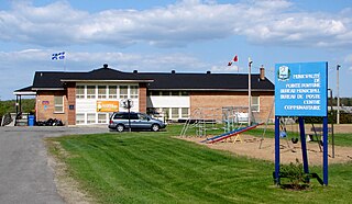
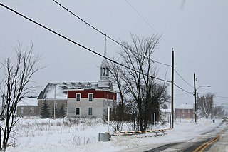
Pointe-Fortune is a village municipality in southwestern Quebec, Canada, on the Ottawa River in Vaudreuil-Soulanges Regional County Municipality, northwest of Montreal. The population at the 2011 Census was 542.
Vaudreuil-Dorion is a suburb of Greater Montreal, in the Montérégie region of southwestern Quebec. The result of the merger of two towns, Vaudreuil and Dorion, it is located in the Vaudreuil-Soulanges Regional County Municipality. Ranked in 2017 as the 15th/100 best cities to raise children in Canada.
Saint-Lazare, also known as Saint-Lazare-de-Vaudreuil, is an off-island suburb of Montreal, in southwestern Quebec, Canada in the Regional County Municipality of Vaudreuil-Soulanges.
Town of Île-Perrot is a town and municipality on Île Perrot in southwestern Quebec, Canada. The population as of the Canada 2011 Census was 10,503. The town is at the western end of Lake Saint-Louis, and borders the local island communities of Terrasse-Vaudreuil, Pincourt and Notre-Dame-de-l'Île-Perrot. It also includes Dowker Island and the small Claude and Bellevue Islands.

Saint-Télesphore is a municipality located in Vaudreuil-Soulanges Regional County Municipality, Quebec (Canada). The population as of the Canada 2011 Census was 762. The municipality is situated west of Saint-Polycarpe and east of the provincial border near North Lancaster, Ontario.

Pincourt is a municipality on the island of Île Perrot, off the western tip of the island of Montreal, Quebec. The population as of the Canada 2011 Census was 14,305. The town shares the island with the three other municipalities of Notre-Dame-de-l'Île-Perrot, Terrasse Vaudreuil and L'Île-Perrot, bordering on each one. The south end of the Ottawa River flows between Vaudreuil-Dorion and Pincourt, defining the town's western boundary.

Terrasse-Vaudreuil is a small municipality on Île Perrot, just west of Montreal Island in Quebec, Canada. Attractions nearby include Le Faubourg de l'Île, the Terrasse-Vaudreuil baseball field, the soccer field, the municipal pool and POLYMOS, a styrofoam company that operates out of an area where gunpowder was produced during World War II. What started as a small cottage community has now evolved into miniature suburbia. Both entrances and exits of Terrasse-Vaudreuil are blocked by CP/CN train tracks, which has caused frustration in the past to residents. However, Terrasse does enjoy a lovely beach that looks out onto Dorion and the Taschereau Bridge.

Saint-Zotique is a municipality located within the Vaudreuil-Soulanges Regional County Municipality in the Montérégie region located about 45 minutes west of Montreal, Quebec, Canada. It is named for Saint Zoticus of Comana.

Saint-Polycarpe is a municipality located in the Vaudreuil-Soulanges Regional County Municipality in the Montérégie region west of Montreal, Quebec, Canada, and just east of the Quebec-Ontario border. It was named for Polycarp, a 2nd-century bishop of Smyrna. The population as of the 2016 Canadian Census was 2,224.

Notre-Dame-de-l'Île-Perrot is the largest of four municipalities located on Île Perrot, west of the island of Montreal, Quebec. The population as of the Canada 2016 Census was 10,654. It hosts the island's first church built in 1740 originally situated at Pointe-du-Moulin which was reconstituted as the Chapelle du Souvenir in 1953 beside the church of Sainte-Jeanne-de-Chantal across from the town hall.
Très-Saint-Rédempteur is a municipality located in the Montérégie region of Quebec, Canada, along the border with Ontario. The population as of the Canada 2011 Census was 863. The municipality includes the town of Saint-Redempteur, and lies south of Rigaud along Route 325.

Sainte-Justine-de-Newton is a municipality located in the Montérégie region of Quebec. The population as of the Canada 2011 Census was 973. The municipality is situated on Route 325 south of Très-Saint-Rédempteur, just east of the Ontario border.
Saint-Clet is a municipality located in the Vaudreuil-Soulanges Regional County Municipality within the Montérégie region of Quebec, Canada. The population as of the Canada 2011 Census was 1,738. Completely surrounded by agricultural land, the town is centred on the intersection of two main provincial highways. The north–south Route 201 is known as rue Principale within the town limits, and the east–west Route 340 is known as Boulevard de la Cité des Jeunes.

Les Coteaux is a municipality in Vaudreuil-Soulanges Regional County Municipality in the Montérégie region of Quebec, Canada. It is located north of the Saint Lawrence River and Salaberry-de-Valleyfield.

Les Cèdres is a municipality located north of the Saint Lawrence River in the Montérégie of Quebec, Canada, near Vaudreuil-Dorion. The population as of the Canada 2011 Census was 6,079. The name means "The Cedars" in French.

Rivière-Beaudette is a municipality of Quebec, Canada, located in the southwest corner of the Vaudreuil-Soulanges Regional County Municipality on the border with Ontario along the Saint Lawrence River. The population as of the Canada 2011 Census was 1,885.

Sainte-Marthe is a municipality located in the Vaudreuil-Soulanges Regional County Municipality of Quebec, Canada. The population as of the Canada 2011 Census was 1,075.

Pointe-des-Cascades is a village municipality in Vaudreuil-Soulanges Regional County Municipality in the Montérégie region of Quebec, Canada. It is located on a spit of land where the Saint Lawrence River flows into Lake Saint-Louis. The river has here a significant drop, forming several cascades which give the village its name.
Vaudreuil-sur-le-Lac is a village municipality in Vaudreuil-Soulanges Regional County Municipality in the Montérégie region of Quebec, Canada. It is located on the western portion of the Vaudreuil Peninsula, which projects into Lake of Two Mountains. The population as of the Canada 2011 Census was 1,359.

L'Île-Cadieux is a village and municipality in the Montérégie region of Quebec, Canada, part of the Vaudreuil-Soulanges Regional County Municipality. It is located on and contiguous with Cadieux Island, which projects into Lake of Two Mountains just north off Vaudreuil-sur-le-Lac. The population as of the Canada 2011 Census was 105.


