
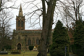
Aslockton is an English village and civil parish 12 miles (19 km) east of Nottingham and 2 miles (3.2 km) east of Bingham, on the north bank of the River Smite opposite Whatton-in-the-Vale. The parish is also adjacent to Scarrington, Thoroton and Orston and within the Rushcliffe borough of Nottinghamshire. The population was recorded as 974 in the 2011 census, doubling to 1,937 at the 2021 census.
Ruddington is a large village in the Borough of Rushcliffe in Nottinghamshire, England. The village is 5 miles (8 km) south of Nottingham and 11 miles (18 km) northwest of Loughborough. It had a population of 6,441 at the 2001 Census, increasing to 7,216 at the 2011 Census and 7,674 in 2021. Ruddington is twinned with Grenay, France.

Stanford on Soar, known locally as Stanford, is a village and civil parish in the Rushcliffe district of Nottinghamshire, England near the River Soar.

Collingham is a village and civil parish in the Newark and Sherwood district, in the county of Nottinghamshire, England. The population of the parish at the 2011 census was 2,738, increasing to 3,052 at the 2021 census.

Balderton is a village and civil parish in Nottinghamshire, England, which had a population of 9,757 at the 2011 census, increasing to 9,917 at the 2021 census.
Kneeton is a hamlet and civil parish in the county of Nottinghamshire, England. The population as of the 2011 census remained less than 100 so was included in the civil parish count for Screveton, it was however reported as 47 residents at the 2021 census. The village lies on the A46 road between Nottingham and Newark and is on the escarpment of the Trent Hills that sit above the flood plain of the River Trent. RAF Syerston is nearby. There is a railway station at Lowdham. The church is 14th century Grade II listed, and dedicated to St. Helen. A mid-18th century Grade II listed barn survives at Hall Farm, Kneeton.

Thurgarton is a small village in rural Nottinghamshire, England. The village is close to Southwell, and Newark-on-Trent and still within commuting distance to Nottingham. It is served by Thurgarton railway station. According to the 2001 census it had a population of 412, increasing to 440 at the 2011 census and marginally to 445 at the 2021 census.

Upton is a small village in Nottinghamshire, England, 2 miles (3.2 km) east of Southwell, 5 miles (8.0 km) west of Newark and 3 miles (4.8 km) south of Hockerton; it lies on the A612 Nottingham-Newark road. In 1889, the village was described as sitting on a bend in the main road, "on the summit of a hill which commands a fine view of the Trent Valley.... The church, which is a prominent feature in the landscape, has a substantial Perpendicular tower crowned by eight pinnacles, and having in the centre a lofty master pinnacle which rises above its neighbours, and so adds materially to the effect."

Hawton is a hamlet and civil parish in the Newark and Sherwood district of Nottinghamshire, England. It lies two miles (3.2 km) south of the town of Newark-on-Trent, near the River Devon, a tributary of the River Trent. Its population was recorded as 147 in the 2011 census. Hawton alone reported 80 residents at the 2021 census.
Kelham is a small village and civil parish in Nottinghamshire, England. It is about 3 miles (4.8 km) northwest of Newark on a bend in the A617 road near its crossing of the River Trent. The population of the civil parish taken at the 2011 census was 207, falling slightly to 203 at the 2021 census.
Owthorpe is an English hamlet and civil parish in the Wolds of the East Midlands county of Nottinghamshire. The population of about 90 was included in the civil parish of Cotgrave in the 2011 census, this increased to 102 at the 2021 census.

Thorpe is a hamlet in the Newark and Sherwood district of Nottinghamshire, England. It lies to the east of East Stoke and 1 mile from the A46 Fosse Way. It i situated in the countryside southwest of Newark. The population was 69 at the 2021 census.

Gonalston is a small village in Nottinghamshire lying just to the north-east of Lowdham and almost upon the A612 trunk road that runs from Nottingham to Southwell. Gonalston comprises 1,096 acres of arable and pasture land in about equal portions, interspersed with 106 acres (0.43 km2) of wood and plantations. It lies on a small river called the Dover Beck which separates the village from Lowdham and which flows south-east into the River Trent 2 miles (3.2 km) away. Population for the 2021 census was 83 residents.

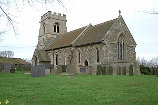
Rolleston is a small village and civil parish in Nottinghamshire by the River Greet, a few miles from Southwell not far from the Trent and about 5 miles (8.0 km) southwest of Newark. The population of the civil parish at the 2011 census was 312, increasing to 342 at the 2021 census. It has a church dedicated to the Holy Trinity. It lies close to the railway line between Nottingham and Lincoln with a station serving the village and Southwell as well as the nearby Southwell Racecourse.

Sibthorpe is a village and civil parish in the borough of Rushcliffe, in Nottinghamshire, England. There is no parish council, only a parish meeting. 123 residents were reported at the 2021 census.
Kirklington is a village and civil parish in the Newark and Sherwood district of Nottinghamshire, England. The population as of the 2011 census was 400, falling to 388 at the 2021 census. Kirklington lies on the A617 road between Newark and Mansfield.
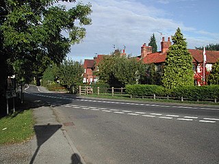
Hawksworth is an English conservation village and civil parish in the Rushcliffe borough of Nottinghamshire. It lies 10 miles (16 km) south of Newark-on-Trent, adjacent to the villages of Flintham, Sibthorpe, Thoroton, Scarrington and Screveton.

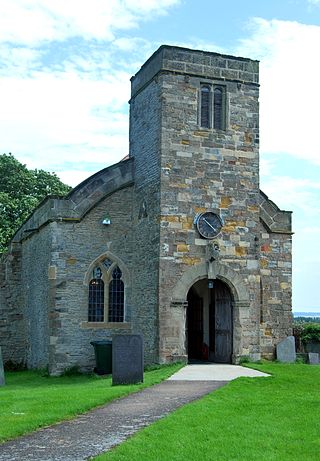
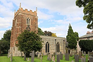
St. Lawrence's Church, Thorpe is a parish church in the Church of England in Thorpe, Nottinghamshire.

North Clifton is a village and civil parish about 12 miles north of Newark-on-Trent, in the Newark and Sherwood district, within the county of Nottinghamshire, England. In 2011, the parish had a population of 216, and this dropped to 176 at the 2021 census. The parish touches Thorney, Fledborough, Newton on Trent, South Clifton and Ragnall.

Staunton is a small village and civil parish in the Newark and Sherwood district of Nottinghamshire, England. It takes its name from the Vale of Belvoir and shares it with the local Staunton family, which has resided in the area since the Norman Conquest and possibly before, making them one of the few English families still resident on their estate.


