The County of Zeeland (Dutch: Graafschap Zeeland) was a county of the Holy Roman Empire in the Low Countries and it later became one of the seven provinces of the Dutch Republic. It covered an area in the Scheldt and Meuse delta roughly corresponding to the modern Dutch province of Zeeland. The County of Zeeland did not include the region of Zeelandic Flanders which was part of Flanders; conversely, the modern Province of Zeeland does not include Sommelsdijk, historically part of the County of Zeeland.
As of 1250, there was no generally recognized Zeeland county title. By the 1323 Treaty of Paris between Flanders and Hainaut-Holland, the Count of Flanders reneged from claims on Zeeland and recognized the count of Holland as Count of Zeeland. With this treaty, the County of Zeeland was now recognized as a clearly demarcated political-administrative entity.[1] Zeeland remained a separate administrative unit, which in turn was under the administration of the counts of Holland. In 1432 it was annexed by the Burgundian duke Philip the Good and became part of the Burgundian Netherlands. After the death of Mary of Burgundy in 1482, Zeeland according to the Treaty of Senlis was one of the Seventeen Provinces held by the House of Habsburg, which in 1512 joined the Burgundian Circle.
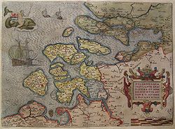
The County of Zeeland in the 15th centurySilver coin: 1 ducaton Dutch Republic, minted in Zeeland in 1790
After the Eighty Years' War, Zeeland was one of the United Provinces of the Dutch Republic established in 1581. Both before and after Dutch independence Zeeland shared some institutions with the States of Holland and West Friesland, such as the supreme court, the Supreme Council of Holland, Zeeland and West-Friesland, after the northern provinces had removed themselves from imperial authority and the jurisdiction of the Grand Council of Mechelen.
After establishment of the States-General of the Netherlands in 1583, Middelburg initially became the place of assembly. From 1585 on they were held in The Hague. As a (theoretically) independent (part) state the county Zealand ceased to exist under the Batavian Republic in 1795, when it became a département. Together with Zeelandic Flanders it today forms the province of Zeeland.
This page is based on this Wikipedia article Text is available under the CC BY-SA 4.0 license; additional terms may apply. Images, videos and audio are available under their respective licenses.