Seventeen Provinces

Last updated

Seventeen Provinces
Zeventien Provinciën (Dutch)
1543–1585
Map of the Habsburg Netherlands by Alexis-Marie Gochet.png
Map of the Seventeen Provinces, 1581 secession outlined in red
Status Personal union of Imperial fiefs
Capital Brussels
Common languages
Religion
Government Monarchy
Historical era Early modern period
1543
 Dutch Act of Abjuration
1585
ISO 3166 code NL
Preceded by
Succeeded by
Flag of Cross of Burgundy.svg Habsburg Netherlands
Dutch Republic Statenvlag.svg
Spanish Netherlands Flag of Cross of Burgundy.svg

The Seventeen Provinces were the Imperial states of the Habsburg Netherlands in the 16th century. They roughly covered the Low Countries, i.e., what is now the Netherlands, Belgium, Luxembourg, and most of the French departments of Nord (French Flanders and French Hainaut) and Pas-de-Calais (Artois). Also within this area were semi-independent fiefdoms, mainly ecclesiastical ones, such as Liège, Cambrai and Stavelot-Malmedy.

Contents

The Seventeen Provinces arose from the Burgundian Netherlands, a number of fiefs held by the House of Valois-Burgundy and inherited by the House of Habsburg in 1482, and held by Habsburg Spain from 1556. Starting in 1512, the Provinces formed the major part of the Burgundian Circle. In 1581, the Seven United Provinces seceded to form the Dutch Republic.

Composition

Seventeen Provinces map by Gabriel Bodenehr Die Niederlande Nach denen XVII Provincien Eingetheilet (Zeventien Provincien der Nederlanden, 17 Provinces) Gabriel Bodenehr.jpg
Seventeen Provinces map by Gabriel Bodenehr
English map of the Seventeen Provinces of Low Germanie Map of Seventeen Provinces of Low Germanie (Zeventien Provincien der Nederlanden) 1626.jpg
English map of the Seventeen Provinces of Low Germanie
Coats of Arms of the Seventeen Provinces Wapens van de Zeventien Provincien 1582, RP-P-1982-1234(R).jpg
Coats of Arms of the Seventeen Provinces

After the Habsburg emperor Charles V had re-acquired the Duchy of Guelders from Duke William of Jülich-Cleves-Berg by the 1543 Treaty of Venlo, the Seventeen Provinces comprised:

Map of the Low Countries in 1477 Map Burgundian Netherlands 1477-en.png
Map of the Low Countries in 1477
Coat of armsNameLatin nameDevelopments
Seventeen Provinces [1] [2] [3] [4]
Counts of Holland Arms.svg County of Holland Holandia [4] Territory integrated into the United Provinces in 1581.
Coatofarmszeeland.PNG County of Zeeland Zelandia [4] Linked to the County of Holland. Territory integrated into the United Provinces in 1581.
Blason Nord-Pas-De-Calais.svg County of Flanders Flandria [4] Including Walloon Flanders (kasselrijen Rijsel, Douai and Orchies) the burgraviates of Lille, the Lordship of Tournai and the Tournaisis (since 1521) nominally part of Flanders.
Arms of Robert dArtois.svg County of Artois Artesia [4] Definitively ceded to France in 1659 by the Treaty of the Pyrenees. Except Aire and Sint-Omaars, ceded with the Treaties of Nijmegen.
Blason fr Hainaut ancien.svg County of Hainaut Hannonia [4]
Namur Arms.svg County of Namur Namurcum [4]
Escudo de Zutphen 1581.png County of Zutphen Zutphania [4] Since 1543. [5] Linked to the Duchy of Gelre. Territory integrated into the United Provinces in 1581 and reintegrated in 1591.
Wapenschild van Brabant.svg Duchy of Brabant Brabantia [4] Including the Lordship of Breda, the counties of Leuven and of Brussels, and the advocacy of the Abbey of Nivelles and of Gembloux, and the "Overmaas" lands of Brabant (Dalhem, Valkenburg and Herzogenrath). Part of the territory was transferred to the United Provinces.
Arms of the Count of Luxembourg.svg Duchy of Luxembourg Lutzenburgum [4]
Modern Arms of Limburg.svg Duchy of Limburg Limburgum [4] Linked to the Duchy of Brabant.
Armoiries Gueldre.svg Duchy of Guelders Gheldria [4] With the Lordship of Drenthe, Lingen, Wedde, and Westerwolde. Since 1543. [5] Territory integrated into the United Provinces in 1581; except one part.
Small coat of arms of Overijssel.svg Lordship of Overijssel Transisulana [4] In Latin, Transisulania. Includes Drente (map of 1658). County of Lingen, Wedde and Westwoldingerland (since 1528). Territory integrated into the United Provinces in 1591. [6]
Escudo de Groniga 1581.svg Lordship of Groningen Gruninga [4] Including the Ommelanden. Since 1536. Territory fully integrated into the United Provinces in 1594. [7]
Small coat of arms of Friesland.png Lordship of Frisia Frislandia [4] Since 1524. Territory integrated into the United Provinces in 1581.
Utrecht - coat of arms.png Lordship of Utrecht Traiectum [4] Since 1528. Territory integrated into the United Provinces in 1581.
Escudo de Malinas 1581.svg Lordship of Mechelen Mechlinia [4] Linked to the Duchy of Brabant. Territory of the United Provinces between 1581-1585. [8]
Blason be Marquisat d Anvers.svg Margraviate of Antwerp Antwerpia [4] Linked to the Duchy of Brabant. Lost by the United Provinces in 1585. [8]

Each province had a distinct Coat of Arms. The States General of the Netherlands had itself its coat, a red shield with an armed golden lion.

It was not always the same seventeen provinces represented at the Estates-General of the Netherlands. Sometimes, one delegation was included in another.

In later years, the County of Zutphen became a part of the Duchy of Guelders, and the Duchy of Limburg was dependent on the Duchy of Brabant. The Lordship of Drenthe is sometimes considered part of the Lordship of Overijssel. On the other hand, the French-speaking cities of Flanders were sometimes recognised as a separate province.
Therefore, in some lists Zutphen and Drenthe are replaced by

There were a number of fiefdoms in the Low Countries that were not part of the Seventeen Provinces, mainly because they did not belong to the Burgundian Circle, but to the Lower Rhenish-Westphalian Circle. The largest of these were the Prince-Bishopric of Liège, including the County of Horne, and the Bishopric of Cambrai. The ethnically and culturally Dutch duchies of Cleves and Julich did not join either. In the north, there were also a few smaller entities like the island of Ameland that would retain their own lords until the French Revolution.

Historians came up with different variations of the list, but always with 17 members. This number could have been chosen because of its Christian connotation. [9]

History

History of the Low Countries
Frisii Belgae
Cana–
nefates
Chamavi,
Tubantes
Gallia Belgica (55 BC–c.5th AD)
Germania Inferior (83–c.5th)
Salian Franks Batavi
unpopulated
(4th–c.5th)
Saxons Salian Franks
(4th–c.5th)
Frisian Kingdom
(c.6th–734)
Frankish Kingdom (481–843)Carolingian Empire (800–843)
Austrasia (511–687)
Middle Francia (843–855) West
Francia

(843–)
Kingdom of Lotharingia (855– 959)
Duchy of Lower Lorraine (959–)
Frisia

Friesland (kleine wapen).svg
Frisian
Freedom

(11–16th
century)
Wapen graafschap Holland.svg
County of
Holland

(880–1432)
Utrecht - coat of arms.png
Bishopric of
Utrecht

(695–1456)
Coat of arms of the Duchy of Brabant.svg
Duchy of
Brabant

(1183–1430)
Guelders-Julich Arms.svg
Duchy of
Guelders

(1046–1543)
Arms of Flanders.svg
County of
Flanders

(862–1384)
Hainaut Modern Arms.svg
County of
Hainaut

(1071–1432)
Arms of Namur.svg
County of
Namur

(981–1421)
Armoiries Principaute de Liege.svg
P.-Bish.
of Liège


(980–1794)
Arms of Luxembourg.svg
Duchy of
Luxem-
bourg

(1059–1443)
  Flag of the Low Countries.svg
Burgundian Netherlands (1384–1482)
Flag of the Low Countries.svg
Habsburg Netherlands (1482–1795)
(Seventeen Provinces after 1543)
 
Statenvlag.svg
Dutch Republic
(1581–1795)
Flag of the Low Countries.svg
Spanish Netherlands
(1556–1714)
 
  Austrian Low Countries Flag.svg
Austrian Netherlands
(1714–1795)
  Flag of the Brabantine Revolution.svg
United States of Belgium
(1790)
LuikVlag.svg
R. Liège
(1789–'91)
   
Flag of the navy of the Batavian Republic.svg
Batavian Republic (1795–1806)
Kingdom of Holland (1806–1810)
Flag of France.svg
associated with French First Republic (1795–1804)
part of First French Empire (1804–1815)
  
Flag of the Netherlands.svg
Princip. of the Netherlands (1813–1815)
 
Kingdom of the Netherlands (1815–1830) Flag of Luxembourg.svg
Gr D. L.
(1815–)
Flag of the Netherlands.svg
Kingdom of the Netherlands (1839–)
Flag of Belgium.svg
Kingdom of Belgium (1830–)
Flag of Luxembourg.svg
Gr D. of
Luxem-
bourg

(1890–)
The Triumph of Death (c. 1562) by Pieter Brueghel the Elder reflects the increasingly harsh treatment the Seventeen Provinces received in the 16th century The Triumph of Death P001393.jpg
The Triumph of Death (c.1562) by Pieter Brueghel the Elder reflects the increasingly harsh treatment the Seventeen Provinces received in the 16th century
Map by Abraham Ortelius from 1573, one of the oldest maps showing the Low Countries Descriptio Germaniae Inferioris Nederlanden Map by Abraham Ortelius 1573.jpg
Map by Abraham Ortelius from 1573, one of the oldest maps showing the Low Countries

The Seventeen Provinces originated from the Burgundian Netherlands. The dukes of Burgundy systematically became the lords of different provinces. Mary I of Valois, Duchess of Burgundy was the last of the House of Burgundy.

Mary married Archduke Maximilian in 1477, and the provinces were acquired by the House of Habsburg on her death in 1482, with the exception of the Duchy of Burgundy itself, which, with an appeal to Salic law, had been reabsorbed into France upon the death of Mary's father, Charles the Bold. Maximilian and Mary's grandson, Charles V, Holy Roman Emperor and king of Spain, eventually united all 17 provinces under his rule, the last one being the Duchy of Guelders, in 1543.

Most of these provinces were fiefs of the Holy Roman Empire. Two provinces, the County of Flanders and the County of Artois, were originally French fiefs, but sovereignty was ceded to the Empire in the Treaty of Cambrai in 1529.

On 15 October, 1506, in the palace of Mechelen, the future Charles V was recognized as Heer der Nederlanden ("Lord of the Netherlands"). Only he and his son ever used this title. The Pragmatic Sanction of 1549 determined that the Provinces should remain united in the future and inherited by the same monarch.

After Charles V's abdication in 1555, his realms were divided between his son, Philip II of Spain, and his brother, Ferdinand I, Holy Roman Emperor. The Seventeen Provinces went to his son, the king of Spain.

Conflicts between Philip II and his Dutch subjects led to the Eighty Years' War, which started in 1568. The seven northern provinces gained their independence as a republic called the Seven United Provinces. They were:

The southern provinces, Flanders, Brabant, Namur, Hainaut, Luxembourg and the others, were restored to Spanish rule due to the military and political talent of the Duke of Parma, especially at the Siege of Antwerp (1584–1585). Hence, these provinces became known as the Spanish Netherlands.

The County of Drenthe, surrounded by the other northern provinces, became de facto part of the Seven United Provinces, but had no voting rights in the Union of Utrecht and was therefore not considered a province.

The northern Seven United Provinces kept parts of Limburg, Brabant, and Flanders during the Eighty Years' War (see Generality Lands), which ended with the Treaty of Westphalia in 1648.

Artois and parts of Flanders and Hainaut (French Flanders and French Hainaut) were ceded to France in the course of the 17th and 18th centuries.

Economy

By the mid-16th century, the Margraviate of Antwerp (Duchy of Brabant) had become the economic, political, and cultural centre of the Netherlands after its capital had shifted from the nearby Lordship of Mechelen to the city of Brussels.

Bruges (County of Flanders) had already lost its prominent position as the economic powerhouse of northern Europe, while Holland was gradually gaining importance in the 15th and 16th centuries.

However, after the revolt of the seven northern provinces (1568), the Sack of Antwerp (1576), the Fall of Antwerp (1584–1585), and the resulting closure of the Scheldt river to navigation, a large number of people from the southern provinces emigrated north to the new republic. The centre of prosperity moved from cities in the south such as Bruges, Antwerp, Ghent, and Brussels to cities in the north, mostly in Holland, including Amsterdam, The Hague, and Rotterdam.

Netherlands

Leo Belgicus map Sitting Leo Belgicus - Visscher.jpg
Leo Belgicus map

To distinguish between the older and larger Low Countries of the Netherlands from the current country of the Netherlands, Dutch speakers usually drop the plural for the latter. They speak of Nederland in the singular for the current country and of de Nederlanden in the plural for the integral domains of Charles V.

In other languages, this has not been adopted, though the larger area is sometimes known as the Low Countries in English.

The fact that the term Netherlands has such different historical meanings can sometimes lead to difficulties in expressing oneself correctly. For example, composers from the 16th century are often said to belong to the Dutch School (Nederlandse School). Although they themselves would not have objected to that term at that time, nowadays it may wrongly create the impression that they were from the current Netherlands. In fact, they were almost exclusively from current Belgium.

Flanders

The same confusion exists around the word Flanders. Historically, it applied to the County of Flanders, corresponding roughly with the present-day provinces of West Flanders, East Flanders and French Flanders. However, when the Dutch-speaking population of Belgium sought more rights in the 19th century, the word Flanders was reused, this time to refer to the Dutch-speaking part of Belgium, which is larger and contains only part of the old county of Flanders (see Flemish Movement). Therefore, the territory of the County of Flanders and that of present-day Flanders do not fully match:

This explains, for instance, why the province of East Flanders is not situated in the east of present-day Flanders.

See also

Related Research Articles

<span class="mw-page-title-main">United Kingdom of the Netherlands</span> 1815–1830 kingdom including the Netherlands and Belgium

The United Kingdom of the Netherlands is the unofficial name given to the Kingdom of the Netherlands as it existed between 1815 and 1830. The United Netherlands was created in the aftermath of the Napoleonic Wars through the fusion of territories that had belonged to the former Dutch Republic, Austrian Netherlands, and Prince-Bishopric of Liège in order to form a buffer state between the major European powers. The polity was a constitutional monarchy, ruled by William I of the House of Orange-Nassau.

<span class="mw-page-title-main">Provinces of Belgium</span> Subdivisions of Belgium

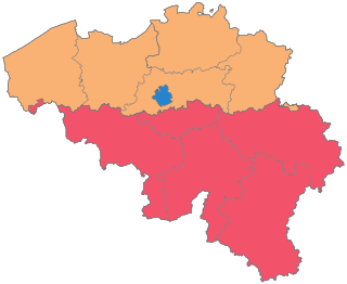
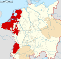
The Kingdom of Belgium is divided into three regions. Two of these regions, Flanders and Wallonia, are each subdivided into five provinces. The third region, Brussels, does not belong to any province and nor is it subdivided into provinces. Instead, it has amalgamated both regional and provincial functions into a single "Capital Region" administration.

<span class="mw-page-title-main">Southern Netherlands</span> Historical region in Belgium

The Southern Netherlands, also called the Catholic Netherlands, were the parts of the Low Countries belonging to the Holy Roman Empire which were at first largely controlled by Habsburg Spain and later by the Austrian Habsburgs until occupied and annexed by Revolutionary France (1794–1815).

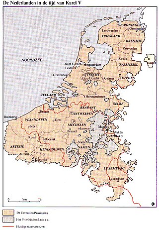
The Pragmatic Sanction of 1549 was an edict, promulgated by Charles V, Holy Roman Emperor, reorganising the Seventeen Provinces of the present-day Netherlands, Belgium, and Luxembourg into one indivisible territory, while retaining existing customs, laws, and forms of government within the provinces.

<span class="mw-page-title-main">County of Hainaut</span> Medieval region in current Belgium and France

The County of Hainaut, sometimes spelled Hainault, was a territorial lordship within the medieval Holy Roman Empire that straddled the present-day border of Belgium and France. Its most important towns included Mons, now in Belgium, and Valenciennes, now in France.

<span class="mw-page-title-main">County of Artois</span> Historic province of the Kingdom of France

The County of Artois was a historic province of the Kingdom of France, held by the Dukes of Burgundy from 1384 until 1477/82, and a state of the Holy Roman Empire from 1493 until 1659.
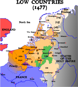
<span class="mw-page-title-main">Burgundian Netherlands</span> The Netherlands from 1384 to 1482

In the history of the Low Countries, the Burgundian Netherlands or the Burgundian Age is the period between 1384 and 1482, during which a growing part of the Low Countries was ruled by the Dukes of Burgundy. Within their Burgundian State, which itself belonged partly to the Holy Roman Empire and partly to the Kingdom of France, the dukes united these lowlands into a political union that went beyond a personal union as it gained central institutions for the first time.
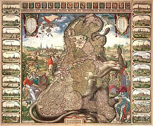
<span class="mw-page-title-main">Spanish Netherlands</span> Historical region of the Low Countries (1556–1714)

Spanish Netherlands was the Habsburg Netherlands ruled by the Spanish branch of the Habsburgs from 1556 to 1714. They were a collection of States of the Holy Roman Empire in the Low Countries held in personal union by the Spanish Crown. This region comprised most of the modern states of Belgium and Luxembourg, as well as parts of northern France, the southern Netherlands, and western Germany with the capital being Brussels. The Army of Flanders was given the task of defending the territory.

<span class="mw-page-title-main">Duchy of Limburg</span> Duchy of the Low Countries (1065–1795)

The Duchy of Limburg or Limbourg was an imperial estate of the Holy Roman Empire. Much of the area of the duchy is today located within Liège Province of Belgium, with a small portion in the municipality of Voeren, an exclave of the neighbouring Limburg Province. Its chief town was Limbourg-sur-Vesdre, in today's Liège Province.

<span class="mw-page-title-main">Burgundian Circle</span> Imperial circle of the Holy Roman Empire

The Burgundian Circle was an Imperial Circle of the Holy Roman Empire created in 1512 and significantly enlarged in 1548. In addition to the Free County of Burgundy, the Burgundian Circle roughly covered the Low Countries, i.e., the areas now known as the Netherlands, Belgium and Luxembourg and adjacent parts in the French administrative region of Nord-Pas-de-Calais. For most of its history, its lands were coterminous with the holdings of the Spanish Habsburgs in the Empire.

<span class="mw-page-title-main">Duchy of Brabant</span> 1183–1794 northwestern state of the Holy Roman Empire

The Duchy of Brabant, a state of the Holy Roman Empire, was established in 1183. It developed from the Landgraviate of Brabant of 1085–1183, and formed the heart of the historic Low Countries. The Duchy comprised part of the Burgundian Netherlands from 1430 and of the Habsburg Netherlands from 1482, until it was partitioned after the Dutch revolt of 1566–1648.

<span class="mw-page-title-main">Guelders Wars</span> Series of conflicts in the Low Countries

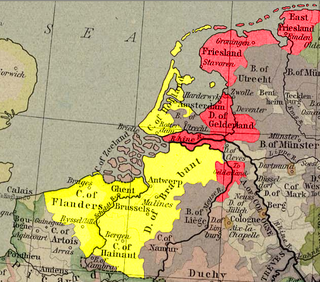
The Guelders Wars were a series of conflicts in the Low Countries between the Duke of Burgundy, who controlled Holland, Flanders, Brabant, and Hainaut on the one side, and Charles, Duke of Guelders, who controlled Guelders, Groningen, and Frisia on the other side.

<span class="mw-page-title-main">Cambrésis</span>

Cambrésis is a former pagus, county and prince-bishopric of the medieval Holy Roman Empire that was annexed to the Kingdom of France in 1679. It is now regarded as one of the "natural regions" of France, and roughly equivalent to the Arrondissement of Cambrai in department Nord. The capital of Cambrésis was Cambrai. Originally ruled by a dynasty of counts, Cambrésis became a prince-bishopric in 1007, comparable to the Prince-Bishopric of Liège and the Prince-Bishopric of Utrecht. It encompassed the territory in which the bishop of Cambrai had secular authority.

<span class="mw-page-title-main">Habsburg Netherlands</span> Entire period of Habsburg rule in the Low Countries (1482-1797)

Habsburg Netherlands was the Renaissance period fiefs in the Low Countries held by the Holy Roman Empire's House of Habsburg. The rule began in 1482, when the last Valois-Burgundy ruler of the Netherlands, Mary, wife of Maximilian I of Austria, died. Their grandson, Emperor Charles V, was born in the Habsburg Netherlands and made Brussels one of his capitals.

<span class="mw-page-title-main">Dutch Republic Lion</span> Historical coat of arms

The Dutch Republic Lion was the badge of the Union of Utrecht, the Republic of the Seven United Netherlands, and a precursor of the current coat of arms of the Kingdom the Netherlands.

<span class="mw-page-title-main">Lordship of Mechelen</span>

The Lordship of Mechelen was a small autonomous Lordship in the Low Countries, consisting of the city of Mechelen and some surrounding villages. It lasted from 910 to 1795.

<span class="mw-page-title-main">County of Flanders</span> Historical territory in present-day Belgium, France, and the Netherlands

The County of Flanders was one of the most powerful political entities in the medieval Low Countries, located on the North Sea coast of what is now Belgium. Unlike its neighbours such as the counties of Brabant and Hainaut, it was within the territory of the Kingdom of France. The counts of Flanders held the most northerly part of the kingdom, and were among the original twelve peers of France. For centuries, the economic activity of the Flemish cities such as Ghent, Bruges and Ypres made Flanders one of the most affluent regions in Europe, and also gave them strong international connections to trading partners.

The Burgundian treaty of 1548, also known as the Transaction of Augsburg, settled the status of the Habsburg Netherlands within the Holy Roman Empire.

<span class="mw-page-title-main">Burgundian State</span> Territories of the Dukes of Burgundy

The Burgundian State is a concept coined by historians to describe the vast complex of territories that is also referred to as Valois Burgundy.

<span class="mw-page-title-main">Gewest</span> Historical regional subdivision of the Netherlands

Gewest is a Dutch term often translated as "region". It was used to describe the various different polities making up the Low Countries, which covered what is now the Netherlands, Belgium, Luxembourg and parts of northern France, until the annexation by France in the late 18th century. The term is now mostly associated with the official titles of the constituent states of Belgium.

References

  1. Arnold Hermann Ludwig Heeren (1834). A Manual of the History of the Political System of Europe and Its Colonies. p. 65.
  2. "De namen van de Zeventien Provinciën (image)". Engelfriet. Archived from the original on 5 April 2022. Retrieved 12 July 2023.
  3. "Ruzie met de Raad van State leidde tot de 80-jarige oorlog". 13 January 2005. Archived from the original on 29 May 2023. Retrieved 12 July 2023.
  4. 1 2 3 4 5 6 7 8 9 10 11 12 13 14 15 16 17 18 "Wapens van de Zeventien Provinciën, Abraham de Bruyn (mogelijk), naar Chrispijn van den Broeck, 1582". Rijksmuseum. Archived from the original on 12 July 2023. Retrieved 12 July 2023.
  5. 1 2 Johan Rudolf Thorbecke, Robert Jacobus Fruin en Herman Theodoor Colenbrander (1922). "2. Verhouding tot het Rijk van de Zeventien Provinciën". Geschiedenis der staatsinstellingen in Nederland tot de dood van Willem II. Universiteit Leiden. Archived from the original on 19 December 2019. Retrieved 19 December 2019.
  6. "De munt van Overijssel". De Kopergeld pagina. 27 October 2004. Archived from the original on 7 April 2008.
  7. "De munt van Groningen". De Kopergeld pagina. 19 October 2004. Archived from the original on 10 March 2008.
  8. 1 2 Modesto Lafuente (1862). Historia general de España, Volume 7. p. 401. Retrieved 12 July 2023.
  9. "The invention of the Dutchman". Leiden University. 20 March 2007. Archived from the original on 17 May 2011. Retrieved 9 August 2020.