
Winchmore Hill is an affluent suburb and electoral ward in the Borough of Enfield, North London, in the N21 postal district. With the Winchmore Hill conservation area as a focal point, the district is bounded on the east by Green Lanes, Barrowell Green, Firs Lane and Fords Grove, and on the north-west by Grovelands Park; in the south it extends to part of Aldermans Hill, and in the north to Vicars Moor Lane and Houndsden Road. Winchmore Hill is 8.9 miles (14.3 km) north north-east of Charing Cross.

The National Highway is a system of roads connecting all mainland states and territories of Australia, and is the major network of highways and motorways connecting Australia's capital cities and major regional centres.
A state highway, state road, or state route is usually a road that is either numbered or maintained by a sub-national state or province. A road numbered by a state or province falls below numbered national highways in the hierarchy. Roads maintained by a state or province include both nationally numbered highways and un-numbered state highways. Depending on the state, "state highway" may be used for one meaning and "state road" or "state route" for the other.

Highways in Australia are generally high capacity roads managed by state and territory government agencies, though Australia's federal government contributes funding for important links between capital cities and major regional centres. Prior to European settlement, the earliest needs for trade and travel were met by narrow bush tracks, used by tribes of Indigenous Australians. The formal construction of roads began in 1788, after the founding of the colony of New South Wales, and a network of three major roads across the colony emerged by the 1820s. Similar road networks were established in the other colonies of Australia. Road construction programs in the early 19th century were generally underfunded, as they were dependent on government budgets, loans, and tolls; while there was a huge increase in road usage, due to the Australian gold rushes. Local government authorities, often known as Road Boards, were therefore established to be primarily responsible for funding and undertaking road construction and maintenance. The early 1900s saw both the increasingly widespread use of motorised transportation, and the creation of state road authorities in each state, between 1913 and 1926. These authorities managed each state's road network, with the main arterial roads controlled and maintained by the state, and other roads remaining the responsibility of local governments. The federal government became involved in road funding in the 1920s, distributing funding to the states. The depression of the 1930s slowed the funding and development of the major road network until the onset on World War II. Supply roads leading to the north of the country were considered vital, resulting in the construction of Barkly, Stuart, and Eyre Highways.

The Princes Highway is a major road in Australia, extending from Sydney to Adelaide via the coast through the states of New South Wales, Victoria and South Australia. It has a length of 1,941 kilometres (1,206 mi) or 1,898 kilometres (1,179 mi) via the former alignments of the highway, although these routes are slower and connections to the bypassed sections of the original route are poor in many cases.

Pymble is a suburb on the Upper North Shore of Sydney in the state of New South Wales, Australia. Pymble is 15 kilometres (9 mi) north-west of the Sydney Central Business District in the local government area of Ku-ring-gai Council.

Tasmania Football Club, commonly known as the Tasmanian Devils, was an Australian rules football club which competed in the Victorian Football League in Australia. Formed in 2001, it was the youngest and the only non-Victorian club in the league. The club was based in the state of Tasmania at Bellerive Oval and was run by AFL Tasmania. At the end of the 2008 season, AFL Tasmania decided to withdraw the Devils from the VFL competition in favour of restarting a new Tasmanian league encompassing the entire state.
A routenumber, designation or abbreviation is an identifying numeric designation assigned by a highway authority to a particular stretch of roadway to distinguish it from other routes and, in many cases, also to indicate its classification, general geographical location and/or orientation. The numbers chosen may be used solely for internal administrative purposes; however, in most cases they are also displayed on roadside signage and indicated on maps.

The Shire of Augusta Margaret River is a local government area in the south-west corner of the South West region of Western Australia, approximately 270 kilometres (168 mi) south of Perth. The shire covers an area of 2,243 square kilometres (866 sq mi) and had a population of over 14,000 at the 2016 Census, about half of whom live in the towns of Margaret River and Augusta.
The Little Sandy Desert, an interim Australian bioregion, is a desert located in Western Australia south of the Great Sandy Desert and west of the Gibson Desert.

Stomp is a percussion group, originating in Brighton, United Kingdom that uses the body and ordinary objects to create a physical theatre performance using rhythms, acrobatics and pantomime.

KGV Oval is the home headquarters of the Glenorchy football and cricket clubs, as well as the Southern Football League.
Daryn Cresswell is a former Australian rules footballer who played for the Sydney Swans in the Australian Football League, and the former senior coach of the Tasmanian Devils Football Club that played in the Victorian Football League.

Aaron William Cresswell is an English professional footballer who plays as a left-back for Premier League club West Ham United and the England national team.

Highways and main roads in the Wheatbelt region of Western Australia form the basis of a road network, which is primarily used by the mining, agriculture, and tourism industries. Main Roads Western Australia maintains and controls these major roads, with offices based in Northam and Narrogin.

Richard Cresswell, DFC was an officer and pilot in the Royal Australian Air Force (RAAF). He held command of No. 77 (Fighter) Squadron twice during World War II, and again during the Korean War. Cresswell was credited with being the first RAAF pilot to shoot down an enemy aircraft at night over Australian soil, the only man to serve as commanding officer of an RAAF squadron on three occasions during wartime, and the first officer to lead a jet-equipped Australian squadron in combat. His performance in Korea earned him both the Commonwealth and the US Distinguished Flying Crosses.
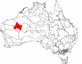
Calvert Road is a designated state route in the Northern Territory of Australia. Forming part of State Route 16, it connects Highway 1 on a joint section of the Savannah Way and Carpentaria Highway near Calvert Hills with the Tablelands Highway near Cresswell Downs.
Barkly Stock Route is a designated state route in the Northern Territory of Australia. Forming part of State Route 16, it connects the Stuart Highway near Elliott with the Tablelands Highway and Cresswell Road.