Deary, Idaho

Last updated • 3 min readFrom Wikipedia, The Free Encyclopedia

Deary, Idaho
Latah County Idaho Incorporated and Unincorporated areas Deary Highlighted 1620890.svg
Location of Deary in Latah County, Idaho
USA Idaho location map.svg
Red pog.svg
Deary, Idaho
Location of Deary in Idaho
Usa edcp location map.svg
Red pog.svg
Deary, Idaho
Deary, Idaho (the United States)
Coordinates: 46°48′01″N116°33′25″W / 46.80028°N 116.55694°W / 46.80028; -116.55694
Country United States
State Idaho
County Latah
Area
[1]
  Total
0.66 sq mi (1.71 km2)
  Land0.66 sq mi (1.70 km2)
  Water0.00 sq mi (0.00 km2)
Elevation
[2]
2,871 ft (875 m)
Population
 (2010) [3]
  Total
506
  Density784.19/sq mi (303.01/km2)
Time zone UTC-8 (Pacific (PST))
  Summer (DST) UTC-7 (PDT)
ZIP code
83823
Area code 208
FIPS code 16-20890
GNIS feature ID2410306 [2]
Website www.dearyidaho.com

Deary is a city in Latah County, Idaho. The population was 506 at the time of the 2010 census, down from 552 in 2000. [4] It is located 24 miles (39 km) east of Moscow and 43 miles (69 km) northeast of Lewiston.

Contents

History

The settlement began as a waystation on the road to the forests at Bovill, Idaho. Owned by two African-Americans, Joe and Lou Wells, the waystation location was first called "Spud Hill", and then "Anderson". [2]

The settlement was renamed "Deary" when the railroad was extended to that point. [5] The town was founded in 1907, and named for William Deary, a businessperson in the lumber industry. [6] [7] A post office has been in operation at Deary since 1907. [8]

Geography

Deary is located at the base of Potato Hill, [5] or as the locals call it, "Spud Hill" and close to outdoor recreation, including camping and fishing: between Spring Valley Reservoir and Moose Creek.

According to the United States Census Bureau, the city has a total area of 0.65 square miles (1.68 km2), all of it land. [9]

Demographics

Historical population
CensusPop.Note
1920 316
1930 295−6.6%
1940 3208.5%
1950 3200.0%
1960 3499.1%
1970 41117.8%
1980 53931.1%
1990 529−1.9%
2000 5524.3%
2010 506−8.3%
2019 (est.)516 [10] 2.0%
U.S. Decennial Census [11]

2010 census

As of the census [3] of 2010, there were 506 people, 204 households, and 143 families residing in the city. The population density was 778.5 inhabitants per square mile (300.6/km2). There were 221 housing units at an average density of 340.0 per square mile (131.3/km2). The racial makeup of the city was 93.5% White, 0.2% African American, 1.0% Native American, 0.8% Asian, 0.8% from other races, and 3.8% from two or more races. Hispanic or Latino of any race were 2.2% of the population.

There were 204 households, of which 33.3% had children under the age of 18 living with them, 57.8% were married couples living together, 7.4% had a female householder with no husband present, 4.9% had a male householder with no wife present, and 29.9% were non-families. 21.6% of all households were made up of individuals, and 9.3% had someone living alone who was 65 years of age or older. The average household size was 2.48 and the average family size was 2.94.

The median age in the city was 39.3 years. 24.5% of residents were under the age of 18; 5.7% were between the ages of 18 and 24; 26% were from 25 to 44; 30% were from 45 to 64; and 13.6% were 65 years of age or older. The gender makeup of the city was 52.4% male and 47.6% female.

2000 census

As of the census [12] of 2000, there were 552 people, 214 households, and 156 families residing in the city. The population density was 921.6 inhabitants per square mile (355.8/km2). There were 235 housing units at an average density of 392.4 per square mile (151.5/km2). The racial makeup of the city was 96.20% White, 0.18% Native American, 0.54% Asian, 0.72% from other races, and 2.36% from two or more races. Hispanic or Latino of any race were 3.44% of the population.

There were 214 households, out of which 33.2% had children under the age of 18 living with them, 62.1% were married couples living together, 5.1% had a female householder with no husband present, and 27.1% were non-families. 21.0% of all households were made up of individuals, and 5.6% had someone living alone who was 65 years of age or older. The average household size was 2.58 and the average family size was 2.97.

In the city, the population was spread out, with 26.4% under the age of 18, 10.1% from 18 to 24, 27.2% from 25 to 44, 23.0% from 45 to 64, and 13.2% who were 65 years of age or older. The median age was 36 years. For every 100 females, there were 97.1 males. For every 100 females age 18 and over, there were 102.0 males.

The median income for a household in the city was $36,167, and the median income for a family was $40,750. Males had a median income of $31,875 versus $19,688 for females. The per capita income for the city was $16,244. About 7.3% of families and 8.7% of the population were below the poverty line, including 15.6% of those under age 18 and 5.6% of those age 65 or over.

Education

Deary has one school, Deary Junior-Senior High School. [13]

See also

Related Research Articles

<span class="mw-page-title-main">Nez Perce County, Idaho</span> County in Idaho, United States

Nez Perce CountyNEZZ-purse; is a county located in the U.S. state of Idaho. As of the 2020 census, the population was 42,090. The county seat is Lewiston. The county is named after the Native American Nez Perce tribe. Nez Perce County is part of the Lewiston, Idaho–WA Metropolitan Statistical Area.

<span class="mw-page-title-main">Shoshone County, Idaho</span> County in Idaho, United States

Shoshone Countyshə-SHOHN is a county in the U.S. state of Idaho. As of the 2020 census, the population was 13,169. The county seat is Wallace and the largest city is Kellogg. The county was established in 1864, named for the Native American Shoshone tribe.

<span class="mw-page-title-main">Latah County, Idaho</span> County in Idaho, United States

Latah County is a county located in the north central region of the U.S. state of Idaho. As of the 2020 census, the population was 39,517. The county seat and largest city is Moscow, the home of the University of Idaho, the state's flagship university.

<span class="mw-page-title-main">Clearwater County, Idaho</span> County in Idaho, United States

Clearwater County is a county located in the U.S. state of Idaho. As of the 2020 census, the population was 8,734. The county seat is Orofino. Established in 1911, the county was named after the Clearwater River. The county is home to North Fork of the Clearwater River, and a small portion of the South Fork and the main Clearwater. Also in the county are the Dworshak Reservoir, Dworshak State Park, Dworshak National Fish Hatchery, and the Dworshak Dam, third highest in the U.S. The modest Bald Mountain ski area is located between Orofino and Pierce.

<span class="mw-page-title-main">Tensed, Idaho</span> City in Idaho, United States

Tensed is a city in Benewah County, Idaho, United States. The population was 123 at the 2010 census, down from 126 in 2000. The city is within the Coeur d'Alene Reservation, and is accessed by U.S. Route 95, the state's primary north-south highway. The city is located about 1 mile (0.6 km) from the north entrance of McCroskey State Park.

<span class="mw-page-title-main">Wilder, Idaho</span> City in Idaho, United States

Wilder is a city in Canyon County, Idaho, United States. The population was 1,533 at the 2010 census.

<span class="mw-page-title-main">Bancroft, Idaho</span> City in Caribou County, Idaho, United States

Bancroft is a city in the Gem Valley in Caribou County, Idaho, United States. The population was 299 at the 2020 census, and 377 at the 2010 census.

<span class="mw-page-title-main">Elk River, Idaho</span> City in Idaho, United States

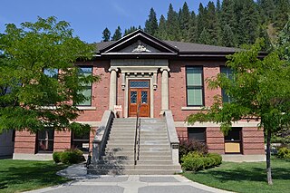
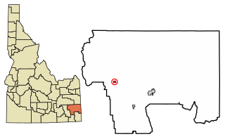
Elk River is a city in the northwestern United States in Clearwater County, Idaho. The population was 125 at the 2010 census, down from 156 in 2000. It is accessed from State Highway 8 from Bovill, to the west in adjacent Latah County. Formerly the site of a Potlatch sawmill, it was phased out after several decades during the 1930s.

<span class="mw-page-title-main">Hazelton, Idaho</span> City in Idaho, United States

Hazelton is a city in Jerome County, Idaho, United States. The population was 807 at the 2020 census. It is part of the Twin Falls, Idaho Micropolitan Statistical Area.

<span class="mw-page-title-main">Bovill, Idaho</span> City in Idaho, United States

Bovill is a city in Latah County, Idaho, United States. The population was 260 at the 2010 census, down from 305 in 2000.

<span class="mw-page-title-main">Genesee, Idaho</span> City in Idaho, United States

Genesee is a city in Latah County, Idaho, United States. The population was 955 at the 2010 census, up from 946 in 2000. The city was named for the Genesee region of western New York, although it may also be a modification of the biblical Genesis.

<span class="mw-page-title-main">Juliaetta, Idaho</span> City in Idaho, United States

Juliaetta is a city in Latah County, Idaho, United States. The town was named after the daughters of an early settler. In 2020, Juliaetta had a population of 624.

<span class="mw-page-title-main">Kendrick, Idaho</span> City in Idaho, United States

Kendrick is a city in Latah County, Idaho, United States. Its population was 303 at the 2010 census, a decrease from 369 in 2000.

<span class="mw-page-title-main">Onaway, Idaho</span> City in Idaho, United States

Onaway is a city in Latah County, Idaho, United States. The population was 187 at the 2010 census, down from 230 in 2000.

<span class="mw-page-title-main">Potlatch, Idaho</span> City in Idaho, United States

Potlatch is a city in the northwest United States, located in north central Idaho in Latah County, about six miles (10 km) east of the border with Washington. On the Palouse north of Moscow, it is served by State Highway 6, and bordered on the northeast by the small community of Onaway. The population of Potlatch was 804 at the 2010 census.

<span class="mw-page-title-main">Troy, Idaho</span> City in Idaho, United States

Troy is a city in Latah County, Idaho, United States. Located in the eastern part of the Palouse region, its population was 862 at the 2010 census.

<span class="mw-page-title-main">Grand View, Idaho</span> City in Owyhee County, Idaho, United States

Grand View is a city along the Snake River in Owyhee County, Idaho, United States. The population was 440 at the 2020 census. It is part of the Boise City–Nampa, Idaho Metropolitan Statistical Area.

<span class="mw-page-title-main">Marsing, Idaho</span> City in Owhyee County, Idaho, United States

Marsing is a city in Owyhee County, Idaho, United States. The population was 1,031 at the time of the 2010 census. It is part of the Boise metropolitan area.

<span class="mw-page-title-main">Fruitland, Idaho</span> City in Payette County, Idaho, United States

Fruitland is a city along the Snake and Payette rivers in Payette County, Idaho, United States. It lies along U.S. Route 95 in the Treasure Valley of southwest Idaho, about 50 miles (80 km) west of Boise on the border with Oregon. It is part of the Ontario Micropolitan Area. Fruitland is named after apple orchards that surround the community, and its slogan is "The Big Apple of Idaho."

<span class="mw-page-title-main">Latah, Washington</span> Town in Washington, United States

Latah is a town in Spokane County, Washington, United States. The population was 185 at the 2020 census. It was named for the nearby creek, Latah Creek, from the native word for fish. The town was formerly called, Hangman's Creek and Alpha.

References

  1. "2019 U.S. Gazetteer Files". United States Census Bureau. Retrieved July 9, 2020.
  2. 1 2 3 U.S. Geological Survey Geographic Names Information System: Deary
  3. 1 2 "U.S. Census website". United States Census Bureau . Retrieved December 18, 2012.
  4. Spokesman-Review Archived 2016-11-20 at the Wayback Machine - 2010 census - Deary, Idaho - accessed 2011-12-26
  5. 1 2 Cross, Helen (March 9, 1978). "Interest in towns revitalized". Spokane Daily Chronicle. p. 3. Retrieved October 31, 2015.
  6. Lewis, Marilyn (May 13, 1988). "Deary named for lumberman". Moscow-Pullman Daily News. p. 26. Retrieved October 18, 2015.
  7. Moyer, Armond; Moyer, Winifred (1958). The origins of unusual place-names. Keystone Pub. Associates. p. 32.
  8. "Latah County". Jim Forte Postal History. Archived from the original on May 23, 2015. Retrieved April 14, 2015.
  9. "US Gazetteer files 2010". United States Census Bureau. Archived from the original on January 25, 2012. Retrieved December 18, 2012.
  10. "Population and Housing Unit Estimates". United States Census Bureau. May 24, 2020. Retrieved May 27, 2020.
  11. "Census of Population and Housing". Census.gov. Retrieved June 4, 2015.
  12. "U.S. Census website". United States Census Bureau . Retrieved January 31, 2008.
  13. "WPJSD #288". City of Deary. Retrieved May 2, 2022.