Deimos, a Greek word for dread, may refer to:
Surrey Satellite Technology Ltd, or SSTL, is a company involved in the manufacture and operation of small satellites. A spin-off company of the University of Surrey, it is presently wholly owned by Airbus Defence and Space.

TopSat is a British Earth observation satellite, currently in Low Earth Orbit. The nanosatellite was launched in October 2005 alongside the Beijing-1 Disaster Monitoring Constellation satellite by a Cosmos rocket from Plesetsk Cosmodrome in Russia.
RazakSAT was a Malaysian Earth observation satellite carrying a high-resolution camera. It was launched into low Earth orbit on 14 July 2009. It was placed in a near-equatorial orbit that presents many imaging opportunities for the equatorial region. It weighs over three times as much as TiungSAT-1 and carries a high-resolution Earth observation camera. Developed in conjunction with the Satrec Initiative, the satellite's low inclination brought it over Malaysia a dozen or more times per day. This was intended to provide greatly increased coverage of Malaysia compared to most other Earth observation satellites. An audit report released in October 2011 revealed that the satellite had failed after one year of operation.

KOMPSAT-2, also known as Arirang-2, is a South Korean multipurpose Earth observation satellite. It was launched from Plesetsk Cosmodrome, Russia at 07:45:43 UTC on 28 July 2006. It began to transmit signals at 14:00 UTC the same day. Like the earlier KOMPSAT-1 satellite, it takes its name from the popular Korean folk song Arirang. Its launch was the culmination of a project begun in 1995.
DubaiSat-1 is a remote sensing Earth observation satellite built by the Mohammed bin Rashid Space Centre (MBRSC) under an agreement with Satrec Initiative, a satellite manufacturing company in South Korea.
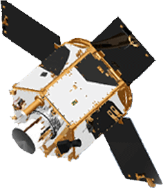
Deimos-1 is a Spanish Earth imaging satellite which is operated by Deimos Imaging who commercializes its imagery directly but also has distribution agreements with other entities like Astrium GEO and DMC International Imaging.
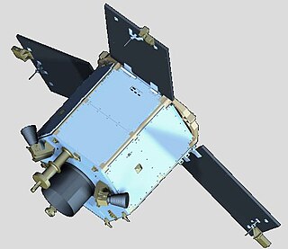
UK-DMC 2 is a British Earth imaging satellite which is operated by DMC International Imaging. It was constructed by Surrey Satellite Technology, based on the SSTL-100 satellite bus. It is part of Britain's contribution to the Disaster Monitoring Constellation, which is coordinated by DMC International Imaging. It is the successor to the UK-DMC satellite.
The SI-200 satellite bus was a model of satellite, based on the Malaysian RazakSAT, produced by the South Korean Satrec Initiative. The bus was suitable for small satellites where the accommodation of Earth observation or other scientific payloads is required, and was used on the Emirati remote sensing satellite DubaiSat-1 launched in 2009.

The Mohammed Bin Rashid Space Center "MBRSC is a Dubai Government organisation, working on the UAE space program which includes various space satellites projects, such as the Emirates Mars Mission, the Emirates Lunar Mission, and the UAE astronaut program. The center actively works to promote space science and research in the region and encompasses the Emirates Institution for Advanced Science and Technology (EIAST).
This page includes a list of satellite buses, of which multiple similar artificial satellites have been, or are being, built to the same model of structural frame, propulsion, spacecraft power and intra-spacecraft communication. Only commercially available buses are included, thus excluding series-produced proprietary satellites operated only by their makers.

DubaiSat-2 is an electro-optical Earth observation satellite built by the Mohammed bin Rashid Space Centre (MBRSC) under an agreement with Satrec Initiative, a satellite manufacturing company in South Korea. MBRSC's objective with DubaiSat-2 is to provide electro-optical images, that can be commercialized, for users within the United Arab Emirates and beyond and to develop and implement new technologies not used in DubaiSat-1. MBRSC also intends to continue manpower training for the UAE's space program. 16 UAE engineers have been working on the design, development, testing and manufacturing of the satellite. The participation of the UAE engineers, who are currently working in South Korea, has increased by 100 percent from the DubaiSat-1 project.
SkySat is a constellation of sub-meter resolution Earth observation satellites owned by Planet Labs, providing imagery, high-definition video and analytics services. Planet acquired the satellites with their purchase of Terra Bella, a Mountain View, California-based company founded in 2009 by Dan Berkenstock, Julian Mann, John Fenwick, and Ching-Yu Hu, from Google in 2017.

Planet Labs PBC is a publicly trading American Earth imaging company based in San Francisco, California. Their goal is to image the entirety of the Earth daily to monitor changes and pinpoint trends.

KhalifaSat, is a remote sensing Earth observation satellite that was designed and built at the Space Technology Laboratories of the Mohammed bin Rashid Space Centre in Dubai. It is considered the first entirely Emirati-made satellite. It launched into orbit on 30 October 2018 from Japan's Tanegashima Space Center using the Korean Satrec SI-300 bus.
Satellogic Inc. is a company specializing in Earth-observation satellites, founded in 2010 by Emiliano Kargieman and Gerardo Richarte.

Martian Moons eXploration (MMX) is a robotic space probe set for launch in 2026 to bring back the first samples from Mars' largest moon Phobos. Developed by the Japan Aerospace Exploration Agency (JAXA) and announced on 9 June 2015, MMX will land and collect samples from Phobos once or twice, along with conducting Deimos flyby observations and monitoring Mars's climate.

Satrec Initiative Co., Ltd. or SI is a South Korean satellite manufacturing company headquartered in Daejeon, South Korea The company was founded in 1999 by the engineers who developed the first Korean satellite (KITSAT-1) at KAIST SaTRec. The company designs and builds Earth observation satellites called SpaceEye-series, and it provides various space components, including high resolution electro-optical payloads and star-trackers. SI's first satellite was a Malaysian Earth observation satellite, RazakSAT launched in 2009. SI has two subsidiaries: SI Imaging Services (SIIS) is the exclusive image data provider of KOMPSAT-series, and SI Analytics (SIA) provides AI-native GEOINT solutions for satellite imagery. SI also spun-off SI Detection (SID), which provides radiation monitoring solutions.

Orbital Express Launch Ltd., or Orbex, is a United Kingdom-based aerospace company that is developing a small commercial orbital rocket called Prime. Orbex is headquartered in Forres, Moray, in Scotland and has subsidiaries in Denmark and Germany. Its future launch complex, Sutherland spaceport, is being built on the A' Mhòine peninsula in the county of Sutherland, northern Scotland.