| Mission type | Earth observation satellite |
|---|---|
| Operator | Wakayama University |
| COSPAR ID | 2014-029B |
| SATCAT no. | 39767 |
| Website | UNIFORM-1 Page |
| Spacecraft properties | |
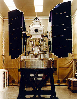
| Launch mass | 50 kg (110 lb) |
| Dimensions | 50 cm × 50 cm × 50 cm (20 in × 20 in × 20 in) [1] |
| Power | 140W |
| Start of mission | |
| Launch date | 24 May 2014 |
| Rocket | H-IIA 202 |
| Launch site | Tanegashima, LA-Y |
| Orbital parameters | |
| Reference system | Geocentric |
| Regime | Sun Synchronous |
| Eccentricity | 0.0013 |
| Perigee altitude | 629.8 km |
| Apogee altitude | 647.4 km |
| Inclination | 97.9 |
| Period | 97.5 min |
| Transponders | |
| Band | S band and X band |
UNIFORM-1 or University International Formation Mission is a Japanese micro-satellite launched in 2014. [2] The satellite is built around a wildfire detection camera and features the following instruments: [3] [4]
All instruments are powered by solar cells mounted on the spacecraft body and stub wings, with estimated electrical power of over 100W.
UNIFORM-1 was launched from Tanegashima, Japan, on 24 May 2014 at 03:05:00 UTC by an H-IIA 202. [5]
The satellite is intended for wildfire detection, especially in the south-east Asia region. [6] The satellite has a less accurate infrared sensor compared to other infrared satellites, but an envisioned constellation of UNIFORM satellites would allow for a short revisit time at the fraction of the cost of the Landsat 7 or MODIS satellites. Mission data is down-linked in S-band and X-band, while control up-link is S-band only. [4]
The Wakayama University and JAXA has refused to publish data and/or information which are not officially published.

Mars 4, also known as 3MS No.52S was a Soviet spacecraft intended to explore Mars. A 3MS spacecraft launched as part of the Mars programme, it was intended to enter orbit around Mars in 1974. However, computer problems prevented orbital insertion from occurring.

The Landsat program is the longest-running enterprise for acquisition of satellite imagery of Earth. It is a joint NASA / USGS program. On 23 July 1972, the Earth Resources Technology Satellite was launched. This was eventually renamed to Landsat 1 in 1975. The most recent, Landsat 9, was launched on 27 September 2021.
Landsat 7 is the seventh satellite of the Landsat program. Launched on 15 April 1999, Landsat 7's primary goal is to refresh the global archive of satellite photos, providing up-to-date and cloud-free images. The Landsat program is managed and operated by the United States Geological Survey, and data from Landsat 7 is collected and distributed by the USGS. The NASA WorldWind project allows 3D images from Landsat 7 and other sources to be freely navigated and viewed from any angle. The satellite's companion, Earth Observing-1, trailed by one minute and followed the same orbital characteristics, but in 2011 its fuel was depleted and EO-1's orbit began to degrade. Landsat 7 was built by Lockheed Martin Space Systems.

Satellite images are images of Earth collected by imaging satellites operated by governments and businesses around the world. Satellite imaging companies sell images by licensing them to governments and businesses such as Apple Maps and Google Maps. It should not be confused for astronomy images collected by space telescope.

Landsat 4 is the fourth satellite of the Landsat program. It was launched on July 16, 1982, with the primary goal of providing a global archive of satellite imagery. Although the Landsat Program is managed by NASA, data from Landsat 4 was collected and distributed by the U.S. Geological Survey. Landsat 4 science operations ended on December 14, 1993 when the satellite lost its ability to transmit science data, far beyond its designed life expectancy of five years. The satellite housekeeping telemetry and tracking continued to be maintained by NASA until it was decommissioned on June 15, 2001.
Landsat 3 is the third satellite of the Landsat program. It was launched on March 5, 1978, with the primary goal of providing a global archive of satellite imagery. Unlike later Landsat satellites, Landsat 3 was managed solely by NASA. Landsat 3 decommissioned on September 7, 1983, beyond its design life of one year. The data collected during Landsat 3's lifetime was used by 31 countries. Countries that cannot afford their own satellite are able to use the data for ecological preservation efforts and to determine the location of natural resources.

CALIPSO is a joint NASA (USA) and CNES (France) environmental satellite, built in the Cannes Mandelieu Space Center, which was launched atop a Delta II rocket on April 28, 2006. Its name stands for Cloud-Aerosol Lidar and Infrared Pathfinder Satellite Observations.

Landsat 2 is the second satellite of the Landsat program. The spacecraft originally carried a designation of ERTS-B but was renamed "Landsat 2" prior to its launch on January 22, 1975. The objective of the satellite was to acquire global, seasonal data in medium resolution from a near-polar, sun-synchronous orbit. The satellite, built by General Electric, acquired data with the Return Beam Vidicon (RBV) and the Multispectral Scanner (MSS). Despite having a design life of one year, Landsat 2 operated for over seven years, finally ceasing operations on February 25, 1982.

Landsat 8 is an American Earth observation satellite launched on 11 February 2013. It is the eighth satellite in the Landsat program; the seventh to reach orbit successfully. Originally called the Landsat Data Continuity Mission (LDCM), it is a collaboration between NASA and the United States Geological Survey (USGS). NASA Goddard Space Flight Center in Greenbelt, Maryland, provided development, mission systems engineering, and acquisition of the launch vehicle while the USGS provided for development of the ground systems and will conduct on-going mission operations. It comprises the camera of the Operational Land Imager (OLI) and the Thermal Infrared Sensor (TIRS) which can be used to study Earth surface temperature and is used to study global warming.

Sentinel-3 is an Earth observation satellite series developed by the European Space Agency as part of the Copernicus Programme. It currently consists of 2 satellites: Sentinel-3A and Sentinel-3B. After initial commissioning, each satellite was handed over to EUMETSAT for the routine operations phase of the mission. Two recurrent satellites— Sentinel-3C and Sentinel-3D— will follow in approximately 2024 and 2028 respectively to ensure continuity of the Sentinel-3 mission.
Marine Observation Satellite-1 (MOS-1), also known as Momo-1, was Japan's first Earth observation satellite. It was launched on 19 February 1987 on a N-II rocket from Tanegashima Space Center and was operated by the National Space Development Agency of Japan (NASDA). It is in a polar orbit at roughly 900 km altitude, but was decommissioned on 29 November 1995.
NOAA B was an American operational weather satellite for use in the National Operational Environmental Satellite System (NOESS) and for the support of the Global Atmospheric Research Program (GARP) during 1978-1984. The satellite design provided an economical and stable Sun-synchronous platform for advanced operational instruments to measure the atmosphere of Earth, its surface and cloud cover, and the near-space environment.

The Joint Polar Satellite System (JPSS) is the latest generation of U.S. polar-orbiting, non-geosynchronous, environmental satellites. JPSS will provide the global environmental data used in numerical weather prediction models for forecasts, and scientific data used for climate monitoring. JPSS will aid in fulfilling the mission of the U.S. National Oceanic and Atmospheric Administration (NOAA), an agency of the Department of Commerce. Data and imagery obtained from the JPSS will increase timeliness and accuracy of public warnings and forecasts of climate and weather events, thus reducing the potential loss of human life and property and advancing the national economy. The JPSS is developed by the National Aeronautics and Space Administration (NASA) for the National Oceanic and Atmospheric Administration (NOAA), who is responsible for operation of JPSS. Three to five satellites are planned for the JPSS constellation of satellites. JPSS satellites will be flown, and the scientific data from JPSS will be processed, by the JPSS – Common Ground System (JPSS-CGS).
IRS-P2 was an Earth observation satellite launched under the National Natural Resources Management System (NNRMS) programme undertaken by Indian Space Research Organisation (ISRO). The objectives of the mission were to provide spaceborne capability to India in observing and managing natural resources and utilizing them in a productive manner. The satellite carried imaging multi-spectral radiometers on board for radio sensing of the resources.

Kosmos 122, launched on 25 June 1966, Meteor No.5L, and was one of eleven weather satellites put into orbit between 1964 and 1969.
Kosmos 156 was a Soviet weather satellite launched on 27 April 1967, one of eleven weather satellites launched by the Soviet Union between 1964 and 1969. It formed part of the experimental "Meteor" weather satellite system. In 1969, the Kosmos satellite series was scrapped for the more modern and updated Meteor satellite.
Cartosat-2E is an Earth observation satellite developed by the Indian Space Research Organisation (ISRO), and is the seventh in the Cartosat series. It is designed to collect high-resolution, large-scale imagery for use in urban planning, infrastructure development, utilities planning, and traffic management.

JPSS-2, or Joint Polar Satellite System-2, is the second of the United States National Oceanic and Atmospheric Administration (NOAA)'s latest generation of U.S. polar-orbiting, non-geosynchronous, environmental satellites called the Joint Polar Satellite System. JPSS-2 is to be launched in September 2022 and join NOAA-20 and Suomi NPP in the same orbit. Circling the Earth from pole-to-pole, it will cross the equator about 14 times daily, providing full global coverage twice a day.
NOAA-20, designated JPSS-1 prior to launch, is the first of the United States National Oceanic and Atmospheric Administration's latest generation of U.S. polar-orbiting, non-geosynchronous, environmental satellites called the Joint Polar Satellite System. NOAA-20 was launched on 18 November 2017 and joined the Suomi National Polar-orbiting Partnership satellite in the same orbit. NOAA-20 operates about 50 minutes ahead of Suomi NPP, allowing important overlap in observational coverage. Circling the Earth from pole-to-pole, it crosses the equator about 14 times daily, providing full global coverage twice a day. This will give meteorologists information on "atmospheric temperature and moisture, clouds, sea-surface temperature, ocean color, sea ice cover, volcanic ash, and fire detection" so as to enhance weather forecasting including hurricane tracking, post-hurricane recovery by detailing storm damage and mapping of power outages.

Cartosat-2F is the eighth satellite in the Cartosat-2 Series. It is an Earth observation satellite launched on the PSLV-C40 mission by the Indian Space Research Organisation (ISRO).