
The Fosse Way was a Roman road built in Britain during the first and second centuries AD that linked Isca Dumnoniorum (Exeter) in the southwest and Lindum Colonia (Lincoln) to the northeast, via Lindinis (Ilchester), Aquae Sulis (Bath), Corinium (Cirencester), and Ratae Corieltauvorum (Leicester).

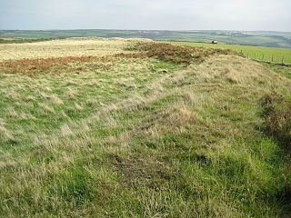
Chanctonbury Ring is a prehistoric hill fort atop Chanctonbury Hill on the South Downs, on the border of the civil parishes of Washington and Wiston in the English county of West Sussex. A ridgeway, now part of the South Downs Way, runs along the hill. It forms part of an ensemble of associated historical features created over a span of more than 2,000 years, including round barrows dating from the Bronze Age to the Saxon periods and dykes dating from the Iron Age and Roman periods.

Wincobank is an Iron Age hill fort near Wincobank in Sheffield, England.

The Vallum is a huge earthwork associated with Hadrian's Wall in England. Unique on any Roman frontier, it runs practically from coast to coast to the south of the wall.
Voley Castle is an Iron Age hill fort situated close to Parracombe in north Devon, England. The fort is situated on a promontory on the eastern side of Heale Down, approximately 230 metres (750 ft) above sea level. It is close to another Iron Age hill fort at Beacon Castle. Voley Castle is a slight univallate hillfort, a rare type of hill fort found mainly in Devon, and is unusual for its type because it has an outer earthwork.
Embury Beacon is the site of an Iron Age promontory fort on the west of the Hartland Peninsula, north of Bude and west of Clovelly, in north Devon. The fort has almost entirely been lost to coastal erosion, but a fraction of the eastern ramparts still exist at approximately 150 metres (490 ft) above Sea Level. It is part of the National Trust property of Bideford Bay and Hartland, which also includes two other hill forts at Windbury Head and Bucks Mills earthworks. The site’s name suggests it was the location of a beacon, possibly during the Elizabethan period, but there is no archaeological evidence of this.
Hembury Castle is an Iron Age hillfort about a mile north-west of the village of Buckfast on the south-eastern edge of Dartmoor in Devon, England. The fort is about 178 metres above sea level on a promontory between the River Dart on the east and the Holy Brook, south-west. The slope down to the River Dart is very steep and is covered by Hembury Woods which is now a Site of Special Scientific Interest.
Holmbury Hill is a wooded area of 261 metres (856 ft) above sea level in Surrey, England, and the site of an Iron Age-period hillfort. The Old Saxon word "holm" can be translated as hill and "bury" means fortified place. It sits along the undulating Greensand Ridge, its summit being 805 feet (245 m) from the elevated and tightly clustered small village of Holmbury St. Mary which was traditionally part of Shere, 8 kilometres (5.0 mi) away.

Blewburton Hill is the site of an Iron Age hillfort located in Oxfordshire, in the southeast of England. It was a univallate hillfort. The area is mostly farmland with some small areas of wooded copse to the south and the northeast. The hill fort may have been occupied from the 4th century BC to the 1st century BC, and replaced a small settlement surrounded by a stockade, which is estimated to have been built in the 5th or 6th century BC.

Woolbury, or Woolbury Ring, is the site of an Iron Age univallate hill fort on Stockbridge Down, Hampshire, England.

Scratchbury Camp is the site of an Iron Age univallate hillfort on Scratchbury Hill, overlooking the Wylye valley about 1 km northeast of the village of Norton Bavant in Wiltshire, England. The fort covers an area of 37 acres (15 ha) and occupies the summit of the hill on the edge of Salisbury Plain, with its four-sided shape largely following the natural contours of the hill.

Cholesbury Camp is a large and well-preserved Iron Age hill fort on the northern edge of the village of Cholesbury in Buckinghamshire, England. It is roughly oval-shaped and covers an area, including ramparts, of 15 acres (6.1 ha), and measures approximately 310 m (1,020 ft) north-east to south-west by 230 m (750 ft) north-west to south-east. The interior is a fairly level plateau which has been in agricultural use since the medieval period. The hill fort is now a scheduled ancient monument.

Bratton Castle is a bivallate Iron Age built hill fort on Bratton Down, at the western edge of the Salisbury Plain escarpment. The hill fort comprises two circuits of ditch and bank which together enclose a pentagonal area of 9.3 hectares.

Limestone Corner is an area of Hadrian's Wall at its most northerly point, in present-day northern England. It represents the most northerly point of the Roman Empire, outside the two periods during which the Antonine Wall was occupied by the Roman military. Other notable features at Limestone Corner are the wall ditch at this point, which was never completely excavated, a Roman camp and the site of Milecastle 30. Also present is a trig point. The B6318 Military Road also runs through Limestone Corner, as does the Military Way, serving Milecastle 30. The Military Way is visible on the ground at this point, the most eastern point where this is the case.

Cornish promontory forts, commonly known in Cornwall as cliff castles, are coastal equivalents of the hill forts and Cornish "rounds" found on Cornish hilltops and slopes. Similar coastal forts are found on the north–west European seaboard, in Normandy, Brittany and around the coastlines of the British Isles, especially in Wales, Scotland and Ireland. Many are known in southwest England, particularly in Cornwall and its neighbouring county, Devon. Two have been identified immediately west of Cornwall, in the Isles of Scilly.
Dudsbury Camp is one of a series of Iron Age earthworks in Dorset, starting from Hambledon Hill, and including Hod Hill, Spetisbury Rings, Buzbury Rings, Badbury Rings and Dudsbury Camp. The Iron Age port at Hengistbury Head forms a final Iron Age monument in this small chain of sites. The fort is located near the village of West Parley.

Torberry Hill is an Iron Age hillfort in the county of West Sussex, in southern England. It is a Scheduled Ancient Monument, with a list entry identification number of 1015966. The hill fort is located within the parish of Harting, within the South Downs National Park. The hill includes the remains of an Early Iron Age univallate hill fort, a Middle Iron Age promontory fort and a post-medieval post mill. The hill is a chalk spur projecting northwards from the South Downs.

Beacon Hill, also known as Harting Beacon, is a hillfort on the South Downs, in the county of West Sussex in southern England. The hillfort is located in the parish of Elsted and Treyford, in Chichester District. It is a Scheduled Ancient Monument with a list entry identification number of 1015915. The hilltop enclosure is dated to the Late Bronze Age, from the 8th to 6th centuries BC. The hillfort defences were renewed during the Late Iron Age.

Cadson Bury is an Iron Age hillfort about 2 miles (3.2 km) south-west of Callington, in Cornwall, England.

The Shipton Hill Settlement is an archaeological site, a defended settlement of the Iron Age, near Shipton Gorge in Dorset, England. It is a scheduled monument.


