
The Devon Redlands is a natural region in southwest Britain that has been designated as National Character Area (NCA) 148 by Natural England. [1]
The Devon Redlands is a natural region in southwest Britain that has been designated as National Character Area (NCA) 148 by Natural England. [1]
The boundary of the Devon Redlands NCA runs along the south Devon coast from Torquay to Otterton before heading almost due north to Burlescombe, then turning northwest to Clayhanger and Shillingford. From Shillingford it runs initially southwest and then south, taking in Bampton, Cove, Loxbeare and Withleigh. South of the A3072 it swings due west in a long finger that extends beyond Bow, but returns via Yeoford and Newton St Cyres before swinging west of Exeter and heading roughly southwards again through Newton Abbot to Torquay. [2]
Neighbouring NCAs are (clockwise from the southwest): South Devon, Dartmoor, The Culm, Exmoor, the Vale of Taunton and Quantock Fringes, the Blackdowns, the Yeovil Scarplands and the Marshwood and Powerstock Vales. [3]
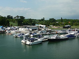
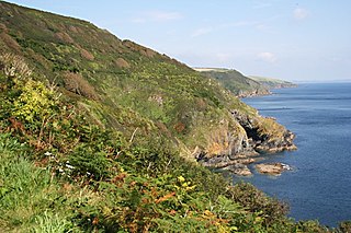
The Devon Redlands have a very strong, unified character, readily visible in the colouration of its ploughed fields, cliffs and outcrops, as well as the building material of its traditional stone and cob farmsteads, hamlets and villages. This colouration is derived from the red sandstone that underlies the area and produces the rich red soils that make the Redlands the agricultural heart of the county of Devon. It is a region of gently rolling hills, with sunken lanes and high hedgerows enclosing smallish fields utilized both for grazing and crops. Rivers are important landscape features; their valleys are flat-bottomed and open up into extensive flood plains in the low-lying terrain of the central Redlands, dominated especially by the estuary of the River Exe south of the city of Exeter. Around this heartland, the land rises towards the edge of the west, north and east of the region. In the south, the coastal strip borders on the English Channel and has achieved partial World Heritage status. [1]

Teignbridge is a local government district in Devon, England. Its council is based in the town of Newton Abbot. The district also includes the towns of Ashburton, Buckfastleigh, Dawlish, Kingsteignton and Teignmouth, along with numerous villages and surrounding rural areas. Teignbridge contains part of the south Devon coastline, including the Dawlish Warren National Nature Reserve. Some of the inland western parts of the district lie within the Dartmoor National Park. It is named after the old Teignbridge hundred.

The Blackdown Hills National Landscape is a National Landscape along the Somerset-Devon border in south-western England, which were designated in 1991 as an Area of Outstanding Natural Beauty (AONB). In November 2023, it has become 'Blackdown Hills National Landscape' The area encompasses a set of hills of the same name.

The Shropshire Hills are a dissected upland area and one of the natural regions of England. They lie wholly within the county of Shropshire and encompass several distinctive and well-known landmarks, such as the Long Mynd, Wenlock Edge, The Wrekin and the Clees.

Carnmenellis Hill gives its name to the area of west Cornwall in England, between Redruth, Helston and Penryn. The hill itself is situated approximately three miles (5 km) south of Redruth. It is one of five Marilyns in Cornwall; the others being Brown Willy, Kit Hill, Hensbarrow Beacon and Watch Croft. The natural region of Carnmenellis has been designated as national character area 155 by Natural England.
South Devon is the southern part of Devon, England. Because Devon has its major population centres on its two coasts, the county is divided informally into North Devon and South Devon. In a narrower sense "South Devon" is used to refer to the part of Devon south of Exeter and Dartmoor, including Plymouth, Torbay and the districts of South Hams, West Devon and Teignbridge.

The Dorset Heaths form an important area of heathland within the Poole Basin in southern England. Much of the area is protected.

The Weymouth Lowlands form a natural region on the south coast of England in the county of Dorset. Much of the area lies with the Dorset Area of Outstanding Natural Beauty.
The Natural Areas of England are regions, officially designated by Natural England, each with a characteristic association of wildlife and natural features. More formally, they are defined as "biogeographic zones which reflect the geological foundation, the natural systems and processes and the wildlife in different parts of England...".
A National Character Area (NCA) is a natural subdivision of England based on a combination of landscape, biodiversity, geodiversity and economic activity. There are 159 National Character Areas and they follow natural, rather than administrative, boundaries. They are defined by Natural England, the UK government's advisors on the natural environment.
The South Coast Plain is a natural region in England running along the central south coast in the counties of East and West Sussex and Hampshire.

The Marshwood and Powerstock Vales form a natural region in southwest England reaching to the Dorset coastline.

The Blackmoor Vale and Vale of Wardour area is a natural region in the counties of Dorset, Somerset and Wiltshire in southern England.

The Yeovil Scarplands are a natural region in southern England in the counties of Somerset and Dorset.

The Mid Somerset Hills are a major natural region in the county of Somerset in southwest west England, forming a series of low hills and ridges that divide up the Somerset Levels.

The Northumberland Sandstone Hills are a major natural region in the English county of Northumberland. The hills form distinctive skylines with generally level tops, northwest facing scarps and craggy outcrops offering views to the Cheviots further west.

The Mid Severn Sandstone Plateau is a rural landscape and one of the natural regions of central England, straddling the border between the counties of Shropshire and Staffordshire. It stretches from the western fringes of the Birmingham conurbation to Telford in the north and Kidderminster in the south. The major feature of the plateau is the valley of the River Severn, which cuts through it from north to south. It consists of Permian and Triassic-age New Red Sandstone getting older as one goes west until one reaches Silurian and Carboniferous-age siltstones and coals west of the river.
The Cornish Killas is a natural region covering most of the county of Cornwall in southwest England. It has been designated as National Character Area 152 by Natural England.

Hensbarrow is a natural region in the county of Cornwall, England, UK, that has been recognized as National Character Area 154 by Natural England.

The Vale of Taunton and Quantock Fringes form a natural region in the southwest of England in the county of Somerset. Natural England have designated the Vale of Taunton and Quantock Fringes as National Character Area 146.

Mar Field Fen is a Site of Special Scientific Interest, or SSSI, north of Masham, North Yorkshire, England, in a rural area known as Marfield. It is situated on land containing woodland carr, fen, spring-fed marshy grassland and drier calcareous grassland, between the River Ure to the east and Marfield Wetland nature reserve to the west. As "one of the best examples of fen habitat in the Vale of York," it is a protected habitat for a variety of plants, including the common butterwort, a carnivorous plant. There is no public access to this site.