
Dighton is a town in Bristol County, Massachusetts, United States. The population was 8,101 at the 2020 census. The town is located on the western shore of the Taunton River in the southeastern part of the state.
The Port of London is that part of the River Thames in England lying between Teddington Lock and the defined boundary with the North Sea and including any associated docks. Once the largest port in the world, it was the United Kingdom's largest port as of 2020. Usage is largely governed by the Port of London Authority ("PLA"), a public trust established in 1908; while mainly responsible for coordination and enforcement of activities it also has some minor operations of its own.
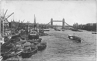
The Pool of London is a stretch of the River Thames from London Bridge to below Limehouse.
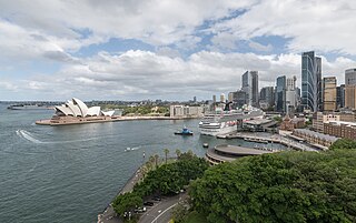
Circular Quay is a harbour, former working port and now international passenger shipping terminal, public piazza and tourism precinct, heritage area, and transport node located in Sydney, New South Wales, Australia, on the northern edge of the Sydney central business district on Sydney Cove, between Bennelong Point and The Rocks. It is part of the local government area of the City of Sydney.

The Port of Boston is a major seaport located in Boston Harbor and adjacent to the City of Boston. It is the largest port in Massachusetts and one of the principal ports on the East Coast of the United States.

The Salem Maritime National Historic Site is a National Historic Site consisting of 12 historic structures, one replica tall-ship, and about 9 acres of land along the waterfront of Salem Harbor in Salem, Massachusetts, United States. Salem Maritime is the first National Historic Site established in the United States. It interprets the Triangle Trade during the colonial period, in cotton, rum, sugar and slaves; the actions of privateers during the American Revolution; and global maritime trade with the Far East, after independence. The National Park Service manages both the National Historic Site and a Regional Visitor Center in downtown Salem. The National Park Service (NPS) is an agency of the United States Department of the Interior.

The Port of San Francisco is a semi-independent organization that oversees the port facilities at San Francisco, California, United States. It is run by a five-member commission, appointed by the Mayor subject to confirmation by a majority of the Board of Supervisors. The Port is responsible for managing the larger waterfront area that extends from the anchorage of the Golden Gate Bridge, along the Marina district, all the way around the north and east shores of the city of San Francisco including Fisherman's Wharf and the Embarcadero, and southward to the city line just beyond Candlestick Point. In 1968, the State of California, via the California State Lands Commission for the State-operated San Francisco Port Authority, transferred its responsibilities for the Harbor of San Francisco waterfront to the City and County of San Francisco / San Francisco Harbor Commission through the Burton Act AB2649. All eligible State port authority employees had the option to become employees of the City and County of San Francisco to maintain consistent operation of the Port of San Francisco.

Pennellville Historic District is a residential district located in Brunswick, Maine. To locals, the neighborhood is known simply as "Pennellville."

Long Wharf is a historic American pier in Boston, Massachusetts, built between 1710 and 1721. It once extended from State Street nearly a half-mile into Boston Harbor; today, the much-shortened wharf functions as a dock for passenger ferries and sightseeing boats.

Front Street is a street on the southeastern side of Lower Manhattan, New York City, running southwest from Dover Street near the Brooklyn Bridge through South Street Seaport to Fulton Street in the Financial District.

The Coram Shipyard Historic District is a historic district encompassing a colonial-era shipyard at 2120, 2125, and 2130 Water Street in Dighton, Massachusetts. The district includes two houses, built c. 1700, and the archaeologically sensitive site of a shipyard which operated for a roughly five-year period between 1698 and 1703. The shipyard site is now home to the Taunton River Yacht Club, whose property includes the wharf built by Thomas Coram and John Hathaway, the proprietors of the shipyard. The district was listed on the National Register of Historic Places in 1998.

The Merrill's Wharf Historic District is a historic district encompassing a portion of the waterfront area of New Bedford, Massachusetts. It encompasses two wharves just to the south of State Pier: the Steamboat Pier and the adjacent Coal Packet Pier. Also included is the stone counting house built by Edward Merrill, the last surviving stone waterfront structure from New Bedford's heyday as a whaling center.

Petrie Bight is a reach of the Brisbane River in Brisbane, Queensland, Australia. The land to the north of the bight, centred on the area under the Story Bridge's northern point and around the Brisbane River to Customs House is also known as Petrie Bight and was formerly a suburb of Brisbane. The area whilst still informally known as Petrie Bight, was absorbed into the suburbs of the Brisbane CBD and Fortitude Valley during consolidation of suburbs by the Brisbane City Council. With a resurgence in Brisbane residents interested in this part of the city and its history, has meant there is a possibility the Brisbane City Council and Queensland Government may once again reinstate Petrie Bight as a suburb to give the area a better sense of identity.

India Wharf in Boston, Massachusetts, flourished in the 19th century, when it was one of the largest commercial wharves in the port. The structure began in 1804 to accommodate international trade at a time when several other improvements to the Boston waterfront occurred, such as the creation of Broad Street and India Street.

Howard Smith Wharves is a heritage-listed wharf on the Brisbane River beneath Bowen Terrace in Brisbane City and Fortitude Valley, Queensland, Australia. It was built from 1939 to 1942, and was known as Brisbane Central Wharves. The 3.5-hectare (8.6-acre) site is one of the most culturally and historically significant riverfront locations in Brisbane. It was added to the Queensland Heritage Register on 4 February 1997.
The Custom House in Boston, Massachusetts, was established in the 17th century and stood near the waterfront in several successive locations through the years. In 1849 the U.S. federal government constructed a neoclassical building on State Street; it remains the "Custom House" known to Bostonians today. A tower was added in 1915; the building joined the National Register of Historic Places in 1973 and was designated a Boston Landmark by the Boston Landmarks Commission in 1986.
The Hamburg Bridge Historic District is located in Lyme, Connecticut. It encompasses a small village which was of economic importance until about 1824, as the site of a bridge across the Eight Mile River since 1759, and as the head of navigation of the river, which feeds the Connecticut River at Hamburg Cove. The district includes 10 houses, all of which are historically significant, as well as old stone wharves dating to the period. The district was added to the National Register of Historic Places on March 10, 1983.

Wellington Harbour Board was the body which formerly managed the shipping and commercial affairs of the port of Wellington in New Zealand. It was constituted in 1880 and was disestablished in 1989.
Lewis Wharf is a showpiece of waterfront urban renewal in Boston's historic North End. The granite structures on the wharf were built as an early 19th-century shopping mall in the era before railroads when water transport was the most efficient way to move commodities to marketplaces.
Ipswich Town Wharves are heritage-listed remnants of wharves beside the Bremer River at Bremer Street, North Ipswich, City of Ipswich, Queensland, Australia. They were built from 1847 to c. 1927. They were also known as Australasian Steam Navigation Wharf and William Collins and Son Wharf, J & G Harris Wharf, and Walter Gray and Co Wharf. They were added to the Queensland Heritage Register on 31 July 2006.


