Docker, Cumbria

Last updated

Docker
Haygarth - geograph.org.uk - 642629.jpg
Haygarth
Cumbria UK location map.svg
Red pog.svg
Docker
Location within Cumbria
Population260 (2011, including Lambrigg) [1]
OS grid reference SD5695
Civil parish
  • Docker
Unitary authority
Ceremonial county
Region
Country England
Sovereign state United Kingdom
Post town KENDAL
Postcode district LA8
Dialling code 01539 [2]
Police Cumbria
Fire Cumbria
Ambulance North West
UK Parliament
List of places
UK
England
Cumbria
54°21′14″N2°40′01″W / 54.354°N 2.667°W / 54.354; -2.667

Docker is a civil parish in the Westmorland and Furness district of the English county of Cumbria. Docker is 4.3 miles north east of the market town of Kendal. At the 2011 census Docker was grouped with Lambrigg giving a total population of 260. [1]

Contents

In 1870–1872, John Marius Wilson from the Imperial Gazetteer of England and Wales described Docker as: "a township in Kendal parish, Westmoreland; near the river Mint and the Lancaster and Carlisle railway 3 miles ENE of Kendal" [3]

Etymology

Diana Whalley's A Dictionary of Lake District Place-Names (English Place Name Society 2006) has this name either as meaning "the shieling at the hollow" or "the shieling where the plant called dock grows" (from Old Norse erg = "summer pasture", taken from Irish airge), or as a personal name which "may have been a link with the family traced in Parker 1918" (Parker C.A. A pedigree of the family of Docker. CW2 18, 161–73). Whalley also refers to "the same problematic syllable in Dockray and ... Dockray Nook" (NY3921 & NY0820).

Demography

Population statistics

The population in 2001 was 55. In the in 2011 census the parish was grouped with Lambrigg, the total population more than quadrupled. The population fluctuations in Docker can be seen in the graph showing the census data every 10 years since 1801. There was no census taken in 1941. This is most likely to have been down to a change in the boundaries of the Parish. It may have been thought having a parish with a population of 55 was not significant enough and as a result the council may have changed the boundaries to even out the distribution.

The male population for Docker and Lambrigg was slightly higher than the female population according to the 2011 census. There was 135 males to 125 females.

The number of people aged 16 and over with 5 or more GCSEs grade A–C (or equivalent) was 10.63%, 4.67% lower than the national average. [1]

Population of Docker from 1801 to 2011 Population of Docker from 1801 - 2011.jpg
Population of Docker from 1801 to 2011

Occupational statistics

In 2011 there were 161 residents in the two parishes that were between the ages of 16 and 74 and in employment. [1] The occupations of the people usually resident at the time of the 2011 census between the ages of 16 and 74 are shown in the pie chart for 2011. The largest population percentage is Professional Occupations category with 23%. The percentage of Skilled Trades Occupations is well above the average for England of 11.4% compared to 17.4% in Docker. [1] Docker is in the countryside so this is due to the thriving agricultural industry in the area. As a result, higher qualifications may be unnecessary for the industry in Docker.

Graph of Occupations for Docker as of the 1881 census Graph of Occupations for Docker (1881).jpg
Graph of Occupations for Docker as of the 1881 census
Occupational graph For Docker 2011 Occupational graph For Docker 2011.jpg
Occupational graph For Docker 2011

Transport

Roads

The A65 road runs through Docker, connecting the A6 and the M6. The A65 runs North West from Leeds in Yorkshire through Ilkley and Skipton before terminating at Kendal in Cumbria.

The M6 Motorway runs from east of Docker from Rugby via Stoke-on-trent, Liverpool and Manchester terminating at Gretna Junction. [4]

Railway line

The nearest railway station to Docker is Kendal station which is 4.7 miles away. The TransPennine Express runs through Kendal from Windermere to Oxenholme. Although Docker does not have its own railway station, the West Coast Mainline runs through Docker from London Euston to Glasgow. The line runs along the Docker viaduct. [5]

The Docker Viaduct on the West Coast Main Line Docker Viaduct 19.10.2016.jpg
The Docker Viaduct on the West Coast Main Line

On 24 February 2007 the 17:15 Virgin train travelling from London Euston to Glasgow Central was derailed 2 miles from Docker near the village of Grayrigg. Several carriages were turned on their side. Cumbria Ambulance service were alerted to the crash at 8.16 pm near Little Docker Cottage. An inquiry found the "immediate cause" of the Grayrigg derailment was a "degraded and unsafe" set of points known as Lambrigg 2B. The train was reported to have lurched side to side in "a very dramatic way"; the train then careered down an embankment, killing 84-year-old Margaret Masson and injuring 22 others. As the rear of the train was crossing the Docker Viaduct, the front of the train was derailed, just beyond the bridge. Thermal imagery equipment was used to detect any trapped survivors. [6] Following the crash, the points that caused the derailment were removed and the line is now welded continuously including the segment on the Docker Viaduct. [7]

Local amenities

The closest primary school to Docker is the Grayrigg Church of England school, 1.5 miles to the north west. The nearest secondary school is the Queen Katherine School in Kendal, a coeducational academy for 11- to 16-year-olds, 3.1 miles away. [8]

The nearest hospital is Westmorland General Hospital, 6.3 km away on Burton Road in Kendal. [9]

The nearest major shopping area to Docker is the Westmoreland Shopping Centre in Kendal, 4.7 miles south west.

Related Research Articles

<span class="mw-page-title-main">Kendal</span> Town in Cumbria, England

Kendal, once Kirkby in Kendal or Kirkby Kendal, is a market town and civil parish in the unitary authority of Westmorland and Furness, England. It lies within the River Kent's dale, from which its name is derived, just outside the boundary of the Lake District National Park.

<span class="mw-page-title-main">Kirkby Lonsdale</span> Town and civil parish in Cumbria, England

Kirkby Lonsdale is a town and civil parish in the Westmorland and Furness district of Cumbria, England, on the River Lune. Historically in Westmorland, it lies 13 miles (21 km) south-east of Kendal on the A65. The parish recorded a population of 1,771 in the 2001 census, increasing to 1,843 at the 2011 Census.

<span class="mw-page-title-main">Milnthorpe</span> Village and civil parish in Cumbria, England

Milnthorpe is a village, civil parish, and former market town in Westmorland and Furness, Cumbria, England. It is 7 miles (11 km) south of Kendal. Historically in the county of Westmorland and on the A6, the village contains several old hostelries and hosts a market every Friday. The parish, which includes the village of Ackenthwaite, had a population of 2,199 according to the 2011 Census.

<span class="mw-page-title-main">Arnside</span> Village and civil parish in Cumbria, England

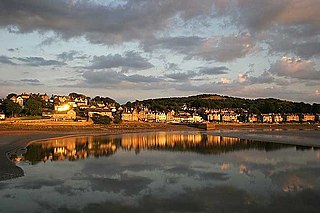
Arnside is a village and civil parish in Westmorland and Furness, Cumbria, England. It is historically part of Westmorland, near the border with Lancashire, England. The Lake District National Park is located a few miles north. Travelling by road, Arnside is 10 miles (16 km) to the south of Kendal, 25.3 miles (40.7 km) to the east of Ulverston, 35.2 miles (56.6 km) to the east of Barrow-in-Furness, 13 miles (21 km) to the north of Lancaster and 14.3 miles (23.0 km) to the east of Grange-over-Sands. In the 2001 census the parish had a population of 2,301, increasing at the 2011 census to 2,334.

<span class="mw-page-title-main">Kirkby Stephen</span> Market town in Cumbria, England

Kirkby Stephen is a market town and civil parish in Cumbria, England. It lies on the A685 and is surrounded by sparsely populated hill country, about 25 miles (40 km) from the nearest larger towns, Kendal and Penrith. The River Eden rises 6 miles (10 km) away in the peat bogs below Hugh Seat and passes the eastern edge of the town. At the 2001 census the parish had a population of 1,832. In 2011, it had a population of 1,522.

<span class="mw-page-title-main">Oxenholme Lake District railway station</span> Railway station in Cumbria, England

Oxenholme Lake District railway station in Oxenholme, near Kendal, Cumbria, England, is on the West Coast Main Line and at the start of the Windermere branch line to Windermere. The station, which serves as a main line connection point for Kendal and Windermere, is managed by Avanti West Coast and owned by Network Rail.

<span class="mw-page-title-main">Oxenholme</span> Village in Cumbria, England

Oxenholme is a village in England just south of the town of Kendal, with which it has begun to merge. It is best known for Oxenholme Lake District railway station on the West Coast Main Line. By strict English definition, Oxenholme is a hamlet rather than a village, as it does not have a church.

<span class="mw-page-title-main">Shap</span> Village and civil parish in Cumbria, England

Shap is a village and civil parish located among fells and isolated dales in Westmorland and Furness, Cumbria, England. The village is in the historic county of Westmorland. The parish had a population of 1,221 in 2001, increasing slightly to 1,264 at the 2011 Census.

<span class="mw-page-title-main">Tebay</span> Village in Cumbria, England

Tebay is a village and civil parish in Cumbria, England, within the historic borders of Westmorland. It lies in the upper Lune Valley, at the head of the Lune Gorge. The parish had a population of 728 in the 2001 census, increasing to 776 at the Census 2011.

<span class="mw-page-title-main">Grayrigg</span> Human settlement in England

Grayrigg is a small village and civil parish in the Westmorland and Furness district of Cumbria, England. In the 2001 census the parish had a population of 223, increasing at the 2011 census to 242. It lies on undulated and partly mountainous land, 4.9 miles (8 km) north east of Kendal, on the north side of the West Coast Main Line, and west side of the M6 motorway.

<span class="mw-page-title-main">Barony of Kendal</span> Subdivision of the English historic county of Westmorland

The Barony of Kendal is a subdivision of the English historic county of Westmorland. It evolved from one of two ancient baronies that make up the county, the other being the Barony of Westmorland. In 1974, the entire county became part of the modern county of Cumbria and ceased to have an administrative function. At the same time, Kendal borough along with some other rural and urban districts in Westmorland was merged with the neighbouring parts of Lancashire, Furness and Cartmel, and also the Sedbergh Rural District of the West Riding of Yorkshire into the new South Lakeland district of the new county.

<span class="mw-page-title-main">Hincaster</span> Human settlement in England

Hincaster is a small hamlet and civil parish in the Unitary Authority of Westmorland and Furness Cumbria, England, located between Kendal and Milnthorpe. In the 2001 census the parish had a population of 195, increasing at the 2011 census to 209.

<span class="mw-page-title-main">Holme, Cumbria</span> Village and civil parish in Cumbria, England

Holme is a village and civil parish in the Westmorland and Furness district of Cumbria, England, about 2 miles (3.2 km) north of Burton-in-Kendal and 3 miles (4.8 km) south east of Milnthorpe. The parish had a population of 1,167 at the 2001 census, increasing to 1,486 at the 2011 Census.

<span class="mw-page-title-main">Casterton, Cumbria</span> Human settlement in England

Casterton is a small village and civil parish close to Kirkby Lonsdale on the River Lune in the south east corner of Cumbria, England. In the 2001 census the parish had a population of 500, decreasing at the 2011 census to 425.

<span class="mw-page-title-main">Grayrigg derailment</span> 2007 rail transport disaster in Grayrigg, England

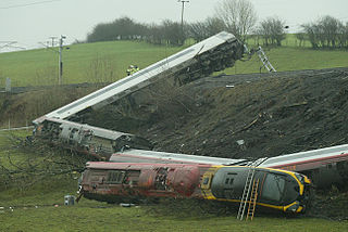
The Grayrigg derailment was a fatal railway accident that occurred at approximately 20:15 GMT on 23 February 2007, just to the south of Grayrigg, Cumbria, in the North West England region of the United Kingdom. The accident investigation concluded that the derailment was caused by a faulty set of points on the Down Main running line, controlled from Lambrigg ground frame. The scheduled inspection on 18 February 2007 had not taken place and the faults had gone undetected.

<span class="mw-page-title-main">Lambrigg Fell</span> 339m high hill in England

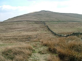
Lambrigg Fell is a hill, the highest point of the area of high ground between Kendal and the M6, in south-eastern Cumbria, England.

<span class="mw-page-title-main">Crooklands</span> Hamlet in Cumbria, England

Crooklands is a hamlet in Westmorland and Furness, Cumbria, England, 4.5 miles (7.2 km) south of Kendal on the A65 road and the Lancaster Canal. Historically part of Westmorland, it is in the parish of Preston Richard but adjacent to Preston Patrick to the south east, the boundary roughly following Peasey Beck. The adjacent showfield of the Westmorland County Agricultural Society is the venue of the annual Westmorland County Show, Country Fest and various other events.

<span class="mw-page-title-main">Grayrigg railway station</span> Disused railway station in Cumbria, England

Grayrigg railway station in Lambrigg parish, was situated on the course of the original Lancaster and Carlisle Railway (L&CR) between Lancaster and Penrith. It served the village and rural district of Grayrigg, Cumbria, England. The new station opened in November 1849, and closed on 1 February 1954 replacing the L&CR station that was located two miles (3.2 km) west of the station and closed in 1849.

<span class="mw-page-title-main">Whinfell</span> Human settlement in England

Whinfell is a civil parish in Westmorland and Furness, Cumbria, England. It does not have a parish council but a parish meeting. The parish lies north east of Kendal, between the A6 and the A685. The neighbouring parishes are Grayrigg to the east, Docker to the south, Skelsmergh to the south west, Selside and Fawcett Forest to the west, and Tebay to the north.

Grayrigg is a civil parish in the South Lakeland District of Cumbria, England. It contains eleven listed buildings that are recorded in the National Heritage List for England. Of these, one is listed at Grade II*, the middle of the three grades, and the others are at Grade II, the lowest grade. The parish is almost entirely rural, the only significant settlement being the village of Grayrigg. The listed buildings include houses, farmhouses, farm buildings, bridges, milestones, a church, and a disused railway viaduct.

References

  1. 1 2 3 4 5 UK Census (2011). "Local Area Report – Docker Parish (E04002601)". Nomis. Office for National Statistics . Retrieved 30 April 2021.
  2. "BT Phone book" . Retrieved 26 March 2015.
  3. Wilson, John Marius (1870). Imperial Gazetteer of England and Wales. South Lakeland and Westmorland: A. Fullerton & Co. Retrieved 27 January 2015.
  4. "Highways England, Driving Forward". Highways England. Retrieved 23 April 2015.
  5. "Virgin Rail Routes and stations". London Euston. Archived from the original on 15 May 2013. Retrieved 21 April 2015.
  6. "Virgin train crashes in Cumbria". The Guardian. 23 February 2007. Retrieved 29 March 2015.
  7. "One dead in Cumbria train crash". BBC NEWS. 24 February 2007. Retrieved 26 March 2015.
  8. "QSK". The Queen Katherine School. Retrieved 23 April 2015.
  9. "HOSPITALS IN DOCKER, KENDAL, CUMBRIA". The West Morland Gasette. Retrieved 23 April 2015.