Dolores, Quezon Last updated October 14, 2025 Municipality in Quezon, Philippines
Municipality in Calabarzon, Philippines
Dolores
Municipality of Dolores Mt. Masalukot, National Shrine of Our Lady of Sorrows, Mount Banahaw, Municipal Hall
Flag
Seal
Nickname: At the foot of Majestic Mt. Banahaw
Motto: "Unlad Dolores!"
Map of Quezon with Dolores highlighted
Coordinates: 14°00′57″N 121°24′04″E / 14.0157°N 121.4011°E / 14.0157; 121.4011 Country Philippines Region Calabarzon Province Quezon District 2nd district Founded April 11, 1835 Annexation to Tiaong May 17, 1902 Chartered April 11, 1910 Barangays Barangays ) • Type Sangguniang Bayan • Mayor Orlan A. Calayag • Vice Mayor Renato B. Alilio Jr. • Representative David C. Suarez • Municipal Council
Belinda P. Cruz Archie L. Abrigo Ma. Aileen C. Corabo John Edward J. Reyes Orlando A. Barsomo Ma. Lilibeth D. Acuña Arturo M. Bagsit Arjay M. Angeles • Electorate 22,229 voters (2025 ) • Total
62.60 km2 (24.17 sq mi) Elevation
328 m (1,076 ft) Highest elevation
2,167 m (7,110 ft) Lowest elevation
38 m (125 ft) • Total
32,645 • Density521.5/km2 (1,351/sq mi) • Households
7,642 Demonym Doloresin • Income class 4th municipal income class • Poverty incidence % (2021) [ 4] • Revenue ₱ 171 million (2022) • Assets ₱ 419.1 million (2022) • Expenditure ₱ 111.8 million (2022) • ElectricityManila Electric Company (Meralco ) Time zone UTC+8 (PST ) ZIP code 4326
PSGC IDD area code +63 (0)42 Native languages Tagalog Website www
Dolores , officially the Municipality of Dolores (Tagalog : Bayan ng Dolores municipality in the province of Quezon , Philippines . According to the 2020 census, it has a population of 32,514 people. [ 5]
History The town was established in 1834 as a pueblo . This was decided by provincial officials of Batangas and Tayabas , with the agreement from the bishop of Nueva Caceres and the archbishop of Manila . It was later approved by the Governor-General of the Philippines that a town shall be founded near Sitio Hambujan. [ 6]
On April 11, 1835, the Governor-General issued a decree establishing the boundary of the town, then known as Nuestra Senora de los Dolores . In May 1835, the local government was inaugurated with Don Francisco Fernando as the first Governadorcillo . The town's seat of government was then Barrio de Maranli (present-day Poblacion), which remains the case until transferring to Bulakin II in September 1966. [ 6]
Beginning on May 17, 1902, Dolores was temporarily consolidated with the municipality of Tiaong (Tiaon) by virtue of Act No. 402. [ 7]
Geography Dolores is located at the foot of Mount Banahaw .
Barangays Dolores is politically subdivided into 16 barangays , as indicated below. Each barangay consists of puroks and some have sitios .
Antonino (Ayusan) Bagong Anyo (Poblacion ) Bayanihan (Poblacion ) Bulakin I Bulakin II Bungoy Cabatang Dagatan Kinabuhayan Maligaya (Poblacion) Manggahan Pinagdanlayan Putol San Mateo Santa Lucia Silanganan (Poblacion) Climate Climate data for Dolores, Quezon Month Jan Feb Mar Apr May Jun Jul Aug Sep Oct Nov Dec Year Mean daily maximum °C (°F) 25 26 28 30 30 29 27 27 27 27 26 25 27 Mean daily minimum °C (°F) 19 19 19 20 22 23 22 22 22 21 20 20 21 Average precipitation mm (inches) 52 35 27 27 82 124 163 144 145 141 100 102 1,142 Average rainy days 12.0 8.1 8.8 9.7 17.9 22.6 26.2 24.5 24.6 22.0 16.7 14.9 208 Source: Meteoblue [ 8]
Demographics Population census of Dolores Year ±% p.a. 1918 4,835 — 1939 6,263 +1.24% 1948 5,612 −1.21% 1960 9,143 +4.15% 1970 12,037 +2.78% 1975 13,617 +2.50% 1980 15,352 +2.43% 1990 18,146 +1.69% 1995 20,749 +2.54% 2000 23,649 +2.84% 2007 26,312 +1.48% 2010 27,702 +1.89% 2015 28,891 +0.80% 2020 32,514 +2.52% 2024 32,645 +0.10% Source: Philippine Statistics Authority [ 9] [ 10] [ 11] [ 12] [ 13]
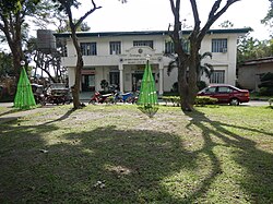
Economy Dolores Municipal Hall Poverty incidence of Dolores
Dolores' economy is primarily based on agriculture. It has 3,858.29 hectares (9,534.0 acres) of land area devoted to local crops such as coconut, rambutan , citrus, and other fruit trees, etc. [ 6]
The business sector of Dolores is dominated by retail of agricultural products. [ 6]
Tourism Bangkong Kahoy Valley Nature Retreat and Field Study Center [ 22] Lukong Valley Farms [ 23] National Shrine of Our Lady of Sorrows [ 24] Paeng Falls Education The Dolores Schools District Office governs all educational institutions within the municipality. It oversees the management and operations of all private and public, from primary to secondary schools. [ 25]
Primary and elementary schools Antonino Elementary School Bulakin Elementary School Bungoy Elementary School CCD School Foundation Dolores Central School Dolores Central School (Annex) Dolores Christian School Don Eulogio Capino Elementary School Don Eulogio Capino Elementary School (Putol Annex) Don Severo Felismino Elementary School Gesu Bambino Parochial School Kinabuhayan Elementary School Our Lady of Sorrows Academy Pedro Bombane Elementary School Pinagdanlayan Elementary School Rosendo Algenio Elementary School Secondary schools Dagatan National High School Sta. Lucia National High School References ↑ Municipality of Dolores | (DILG) ↑ "2015 Census of Population, Report No. 3 – Population, Land Area, and Population Density" (PDF) . Philippine Statistics Authority . Quezon City, Philippines. August 2016. ISSN 0117-1453 . Archived (PDF) from the original on May 25, 2021. Retrieved July 16, 2021 . ↑ "2024 Census of Population (POPCEN) Population Counts Declared Official by the President" . Philippine Statistics Authority. 17 July 2025. Retrieved 18 July 2025 . ↑ "PSA Releases the 2021 City and Municipal Level Poverty Estimates" . Philippine Statistics Authority. 2 April 2024. Retrieved 28 April 2024 . ↑ "2024 Census of Population (POPCEN) Population Counts Declared Official by the President" . Philippine Statistics Authority. 17 July 2025. Retrieved 18 July 2025 . 1 2 3 4 5 "LGU Profile - Dolores Quezon" . ↑ Act No. 402 (May 17, 1902), An Act Consolidating the Municipalities of Tiaon, Dolores, Candelaria, and Sariaya in the Province of Tayabas Into Two Municipalities , retrieved September 21, 2024 ↑ "Dolores: Average Temperatures and Rainfall" . Meteoblue. Retrieved 25 January 2020 . ↑ "2024 Census of Population (POPCEN) Population Counts Declared Official by the President" . Philippine Statistics Authority. 17 July 2025. Retrieved 18 July 2025 . ↑ Census of Population (2015). "Region IV-A (Calabarzon)" . Total Population by Province, City, Municipality and Barangay . Philippine Statistics Authority . Retrieved 20 June 2016 . ↑ Census of Population and Housing (2010). "Region IV-A (Calabarzon)" (PDF) . Total Population by Province, City, Municipality and Barangay . National Statistics Office . Retrieved 29 June 2016 . ↑ Censuses of Population (1903–2007). "Region IV-A (Calabarzon)" . Table 1. Population Enumerated in Various Censuses by Province/Highly Urbanized City: 1903 to 2007 National Statistics Office . ↑ "Province of" . Municipality Population Data . Local Water Utilities Administration Research Division. Retrieved 17 December 2016 . ↑ "Poverty incidence (PI):" . Philippine Statistics Authority. Retrieved December 28, 2020 . ↑ "Estimation of Local Poverty in the Philippines" (PDF) . Philippine Statistics Authority. 29 November 2005. ↑ "2003 City and Municipal Level Poverty Estimates" (PDF) . Philippine Statistics Authority. 23 March 2009. ↑ "City and Municipal Level Poverty Estimates; 2006 and 2009" (PDF) . Philippine Statistics Authority. 3 August 2012. ↑ "2012 Municipal and City Level Poverty Estimates" (PDF) . Philippine Statistics Authority. 31 May 2016. ↑ "Municipal and City Level Small Area Poverty Estimates; 2009, 2012 and 2015" . Philippine Statistics Authority. 10 July 2019. ↑ "PSA Releases the 2018 Municipal and City Level Poverty Estimates" . Philippine Statistics Authority. 15 December 2021. Retrieved 22 January 2022 . ↑ "PSA Releases the 2021 City and Municipal Level Poverty Estimates" . Philippine Statistics Authority. 2 April 2024. Retrieved 28 April 2024 . ↑ "Bangkong Kahoy Valley Official Website" . bangkong kahoy valley . Retrieved 2020-02-27 . ↑ "Lukong Valley Farms Agriventures Inc., marks 10th LS in Quezon province" . Department of Agriculture . Retrieved 27 February 2020 . ↑ "CBCP declares church in Quezon town National Shrine of Our Lady of Sorrows" . Manila Bulletin . Retrieved 2020-02-27 . ↑ "Masterlist of Schools" (PDF) . Department of Education . January 15, 2021. Retrieved October 11, 2025 . External links
Places adjacent to Dolores, Quezon
This page is based on this
Wikipedia article Text is available under the
CC BY-SA 4.0 license; additional terms may apply.
Images, videos and audio are available under their respective licenses.