
Lincoln Parish is a parish located in the U.S. state of Louisiana. As of the 2020 census, the population was 48,396. The parish seat is Ruston. The parish was created on February 24, 1873, from parts of Bienville, Claiborne, Union, and Jackson parishes, and its boundaries have changed only once. This makes Lincoln Parish one of the Reconstruction parishes.

Vienna is a town in Lincoln Parish, Louisiana, United States. The population was 483 in 2020.

U.S. Route 80 or U.S. Highway 80 (US 80) is a major east–west United States Numbered Highway in the Southern United States, much of which was once part of the early auto trail known as the Dixie Overland Highway. As the "0" in the route number indicates, it was originally a cross-country route, from the Pacific Ocean to the Atlantic Ocean. Its original western terminus was at Historic US 101 in San Diego, California. However, the entire segment west of Dallas, Texas, has been decommissioned in favor of various Interstate Highways and state highways. Currently, the highway's western terminus is at an interchange with Interstate 30 (I-30) on the Dallas–Mesquite, Texas city line. Its eastern terminus is in Tybee Island, Georgia near the Atlantic Ocean. Between Jonesville, Texas and Kewanee, Mississippi, US 80 runs parallel to or concurrently with Interstate 20. It also currently runs through Dallas, Texas; Shreveport, Louisiana; Jackson, Mississippi; Montgomery, Alabama; Columbus, Georgia; Macon, Georgia; and Savannah, Georgia.

U.S. Route 45 is a major north-south United States highway and a border-to-border route, from Lake Superior to the Gulf of Mexico. A sign at the highway's northern terminus notes the total distance as 1,297 miles (2,087 km).

Nicollet Avenue is a major street in Minneapolis, Richfield, Bloomington, and Burnsville in the U.S. state of Minnesota. It passes through a number of locally well-known neighborhoods and districts, notably Eat Street in south Minneapolis and the traffic-restricted Nicollet Mall in downtown Minneapolis.

Gunter Annex is a United States Air Force installation located in the North-northeast suburbs of Montgomery, Alabama. The base is named after former Montgomery mayor William Adams Gunter. Until 1992 it was known as Gunter Air Force Base or Gunter Air Force Station. It has been a military training base since its opening in 1940.

The downtown of Duluth, Minnesota, United States, is situated between Mesaba Avenue and 4th Avenue East; and located on Michigan, Superior, First, Second, and Third streets.
Bryan Place is a neighborhood in Old East Dallas, Texas (USA). It is east of the Arts District of downtown and the State Thomas neighborhood, north of Deep Ellum, south of Cityplace and west of Munger Place. Its boundaries are generally considered to be US-75 North Central Expressway on the west, Ross Avenue on the (north)west, N. Washington Street on the (north)east, and Live Oak Avenue on the (south)east.

North Philadelphia station is an intercity rail and regional rail station on the Northeast Corridor, located on North Broad Street in the North Philadelphia neighborhood of Philadelphia, Pennsylvania, United States. SEPTA Regional Rail's Trenton Line and Chestnut Hill West Line account for most of the station's service. Four Amtrak trains, three southbound and one northbound, stop on weekdays only.

U.S. Route 1 (US 1) is a major north–south U.S. Route, extending from Key West, Florida, in the south to Fort Kent, Maine, at the Canada–United States border in the north. In the U.S. state of Pennsylvania, US 1 runs for 81 miles (130 km) from the Maryland state line near Nottingham northeast to the New Jersey state line at the Delaware River in Morrisville, through the southeastern portion of the state. The route runs southwest to northeast and serves as a major arterial road through the city of Philadelphia and for many of the suburbs in the Delaware Valley metropolitan area. South of Philadelphia, the road mostly follows the alignment of the Baltimore Pike. Within Philadelphia, it mostly follows Roosevelt Boulevard. North of Philadelphia, US 1 parallels the route of the Lincoln Highway. Several portions of US 1 in Pennsylvania are freeways, including from near the Maryland state line to Kennett Square, the bypass of Media, the concurrency with Interstate 76 and the Roosevelt Expressway in Philadelphia, and between Bensalem Township and the New Jersey state line.

Cortez Hill is a neighborhood located in the northeast part of Downtown San Diego, California.

J.C. Love Field at Pat Patterson Park is a baseball stadium in Ruston, Louisiana, United States. It is the home field of the Louisiana Tech University Bulldogs college baseball team.

Carr Square is a neighborhood of St. Louis, Missouri. The Downtown neighborhood is bounded by Cass Avenue on the North, Carr Street on the South, North Tucker Boulevard and North 13th Street on the East, and North Jefferson on the West.
Marine Villa is a neighborhood of St. Louis, Missouri. The neighborhood is located just south of the large and historic Anheuser-Busch Brewery complex along the bluffs of the Mississippi River. It is further defined by Cherokee Street's Antique Row on the north, Gasconade Street on the south, South Broadway and Jefferson Avenue on the west, and the Mississippi River on the east.
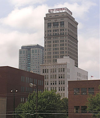
The City Federal Building is a skyscraper located on Second Avenue North in Birmingham, Alabama. It was built in 1913 and was designed by architect William C. Weston. It stands 27 stories or 325 feet on the Birmingham skyline.
The streets of St. Louis, Missouri, United States, and the surrounding area of Greater St. Louis are under the jurisdiction of the City of St. Louis Street Department. According to the Streets Division, there are 1,000-mile (1,600 km) of streets and 600-mile (970 km) of alleys within the city.

The Hamburg Historic District, also known as the Gold Coast, is a residential neighborhood located on a bluff northwest of downtown Davenport, Iowa, United States. It is listed on the National Register of Historic Places in 1983. In 1999, it was listed on the Davenport Register of Historic Properties The historic district is where the city's middle and upper-income German community built their homes in the 19th and early 20th centuries. Germans were the largest ethnic group to settle in Davenport.

The Stedman–Thomas Historic District encompasses what was historically the southern portion of Ketchikan, Alaska. It extends along Stedman and Thomas Streets, from Ketchikan Creek in the north to East Street in the south, and includes a few properties on adjacent spur side streets. In the early days of the city, the area was a seasonal Native fishing camp just south of the creek, but the Alaskan gold rushes around the turn of the 20th century brought an influx of settlers to the area.
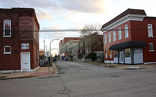
The Homer Historic District, a 13 acres (5.3 ha) historic district in Homer in Claiborne Parish, Louisiana, was listed on the National Register of Historic Places in 1986.

The Iroquois Hotel New York is located at 49 West 44th Street between Fifth Avenue and Sixth Avenue in the Midtown Manhattan neighborhood of New York City. It is one of six hotels owned by Shimmie Horn and Gerald Barad under the Triumph Hotels brand. The hotel is part of Small Luxury Hotels of the World, a European-based referral service that sets standards for furnishings and service.


