Draughton, North Yorkshire

Last updated • 4 min readFrom Wikipedia, The Free Encyclopedia

Draughton
Main road in Draughton heading south.jpg
The village's main street in the summer of 2007.
North Yorkshire UK location map (2023).svg
Red pog.svg
Draughton
Location within North Yorkshire
Population270  [1]
OS grid reference SE039524
Civil parish
  • Draughton
Unitary authority
Ceremonial county
Region
Country England
Sovereign state United Kingdom
Post town SKIPTON [2]
Postcode district BD23 [2]
Police North Yorkshire
Fire North Yorkshire
Ambulance Yorkshire
UK Parliament
List of places
UK
England
Yorkshire
53°58′05″N1°56′31″W / 53.967930°N 1.941810°W / 53.967930; -1.941810

Draughton ( /ˈdræftən/ DRAF-tən [3] ) is a village and civil parish east of Skipton in North Yorkshire, England. In 2015, the population of the parish was 270. The boundaries of the parish extend beyond the village proper: eastwards they go to the River Wharfe, including ancient woodland. The village dates back to the time of the Domesday book and has several listed buildings. The civil parish lies next to both Yorkshire Dales National Park and to the Nidderdale Area of Outstanding Natural Beauty. The ground the parish sits on includes mudstone and limestone.

Contents

The A65 road crosses through the centre of the civil parish and by the village; the A59 road is just outside the northward boundary. The parish includes Bolton Abbey railway station. The civil parish is administered by a parish council comprising seven members; in the North Yorkshire Council it is represented by Wharfedale ward; and at the House of Commons by the constituency of Skipton and Ripon.

Name

Draughton has been historically written in various forms, including Dracton in the Domesday Book, and later Drahton, Draython, and Draghton. It was spelled Draughton as early as 1423. The name includes the Old Danish drag, meaning a slope or a portage, and the Old English tūn, simply meaning a dwelling-place or settlement. The Old Danish part may have replaced another Old English element, dræg, meaning a portage or path. [4] [5]

Upland near the village of Draughton. Towards Draughton Height - geograph.org.uk - 2897188.jpg
Upland near the village of Draughton.

Geography

Draughton is located east of Skipton. The boundaries of the civil parish extend around and to the east of the village proper, and include the Chelker Reservoir. To the east, the parish extends about 1.9 miles (3 km) to the River Wharfe and includes three hills and some pockets of ancient woodland; the hamlet of Bolton Bridge, outside the parish boundaries, marks the north-east corner. The parish boundaries extend 1.2 miles (2 km) to the south of the village, and include Draughton moor. Northwards and westwards, the parish boundaries follow becks. [6]

The parish of Draughton is surrounded to the north by Yorkshire Dales National Park, to the east by the Nidderdale Area of Outstanding Natural Beauty, and to the south by the Bradford green belt. [6]

Transport

The heritage Embsay and Bolton Abbey Steam Railway passes near the village, [7] and that line's Bolton Abbey Railway station lies within the parish boundaries. The A59 road lies just outside of the parish's northern boundary, while the A65 passes through the centre of the parish. [6]

The main street of the village, Low Lane, runs roughly north–south; there is a small stream that runs just east of the village. The A65 road marks the bottom of the settled area. There is a church named after Saint Augustine in the village. [8] [9]

The Dales Way passes through the parish's area, in the segment that connects the village of Addingham with Bolton Abbey. In 2024, a new footpath was added to take walkers off the B6160 road east of the village proper, near Bolton Bridge. [10]

Geology

The village itself sits mostly on carboniferous mudstone, part of the Hodder Mudstone formation, and is partially surrounded by large patchy swathes of limestone dating to the same era. The rest of the parish is more geologically diverse: a large area to the east of the village is shale, followed by sandstone around the River Wharfe. [11]

Population

The population of the civil parish was 270 in 2015. [1] In 1911, it was 166; this continued to decline during the 20th century until an increase by 1971. [12]

History

The village was recorded in the Domesday Book. [13] In St. Augustine’s Church, there is a plaque honouring the four men from Draughton who died in the First World War, and the one man who died in the Second World War. [14] The Draughton post office was closed in 2008. [15] In 2022, disinfection measures were temporarily introduced to a water treatment plant near Draughton to help improve the water quality of a swimming spot at Ilkley in the River Wharfe, after a report that May showed that the river at Ilkley had the lowest water quality in the UK that summer. [16] [17]

Heritage

Lob Wood, an ancient woodland in the civil parish. Redundant Wall in Lob Wood - geograph.org.uk - 6011265.jpg
Lob Wood, an ancient woodland in the civil parish.

There are several listed buildings in the parish of Draughton, including buildings and boundary stones. The Flat Bridge, which takes the B6160 road over a stream, was built around 1800. Besides five boundary stones and other markers, there is also an 18th-century farmhouse, a lime kiln, and a house dating to around 1810. [18] In addition, there are two ancient woodlands – forests which have existed since 1600 – within the parish, Lob Wood and Eller Carr Wood. [6]

Politics

The Draughton village hall. Draughton village hall - geograph.org.uk - 6119660.jpg
The Draughton village hall.

As a civil parish, Draughton is administered on the lowest level of local government by a parish council. The Draughton parish council has seven members who are elected to four year terms. [19] At the second level of local government – the North Yorkshire Council, which is a unitary authority – Draughton is part of the Wharfedale ward. [6] At the national level, the parish is represented by the constituency of Skipton and Ripon. [20]

Related Research Articles

<span class="mw-page-title-main">Embsay and Bolton Abbey Steam Railway</span> Heritage railway in North Yorkshire, England

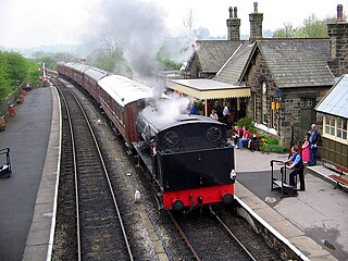
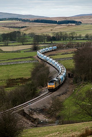
The Embsay and Bolton Abbey Steam Railway (E&BASR) is a heritage railway in North Yorkshire, England, formed in 1979 and opened in 1981.

<span class="mw-page-title-main">Bolton Abbey</span> Site of 12th century Augustinian monastery

Bolton Abbey Estate in Wharfedale, North Yorkshire, England, takes its name from a 12th-century Augustinian monastery of canons regular, now known as Bolton Priory. The priory, which was closed in the 1539 Dissolution of the Monasteries ordered by King Henry VIII, is in the Yorkshire Dales, which lies next to the village of Bolton Abbey.

<span class="mw-page-title-main">Ilkley</span> Town and civil parish in West Yorkshire, England

Ilkley is a spa town and civil parish in the City of Bradford in West Yorkshire, in Northern England. Historically part of the West Riding of Yorkshire, Ilkley civil parish includes the adjacent village of Ben Rhydding and is a ward within the City of Bradford. Approximately 12 miles (19 km) north of Bradford and 17 miles (27 km) north-west of Leeds, the town lies mainly on the south bank of the River Wharfe in Wharfedale, one of the Yorkshire Dales.

<span class="mw-page-title-main">Arthington</span> Village and civil parish in Leeds, West Yorkshire, England

Arthington is a linear village in Wharfedale, in the City of Leeds metropolitan borough in West Yorkshire, England. It is a civil parish which, according to the 2011 census, had a population of 532. It is in the Otley ward of the City of Leeds, and the Leeds North West parliamentary constituency.

<span class="mw-page-title-main">Craven District</span> Former local government district in North Yorkshire, England

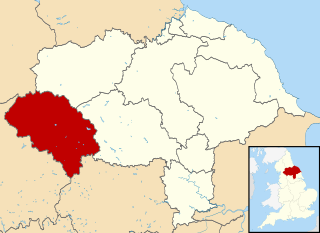
Craven was a non-metropolitan district in the west of North Yorkshire, centred on the market town of Skipton. The name Craven is much older than the modern district and encompassed a larger area. This history is also reflected in the way the term is still commonly used, such as by the Church of England.

<span class="mw-page-title-main">Ilkley Roman Fort</span> Roman Fort in West Yorkshire, England

Ilkley Roman Fort is a Roman fort on the south bank of the River Wharfe, at the centre of the modern town of Ilkley, a Victorian spa town in West Yorkshire, England.

<span class="mw-page-title-main">Grassington</span> Village and civil parish in North Yorkshire, England

Grassington is a town and civil parish in North Yorkshire, England. The population of the parish at the 2011 Census was 1,126. Historically part of the West Riding of Yorkshire, and now in the lieutenancy area of North Yorkshire, the village is situated in Wharfedale, about 8 miles (10 km) north-west from Bolton Abbey, and is surrounded by limestone scenery. Nearby villages include Linton, Threshfield, Hebden, Conistone and Kilnsey.

<span class="mw-page-title-main">Kilnsey</span> Village in North Yorkshire, England

Kilnsey is a small village in Wharfedale, North Yorkshire, England. It lies on the B6160 road, between the villages of Grassington and Kettlewell, near Arncliffe and just across the River Wharfe from Conistone. The village is 12 miles (19 km) north of Skipton and 3 miles (5 km) south of Kettlewell.

<span class="mw-page-title-main">Appletreewick</span> Village and civil parish in North Yorkshire, England

Appletreewick is a village and civil parish in the Craven district of North Yorkshire, England, 6.5 miles (10.5 km) north-east of Skipton, 7 miles (11 km) from Skipton railway station and 16 miles (25.7 km) from Leeds Bradford International Airport.

<span class="mw-page-title-main">Barden, Craven</span> Civil parish in North Yorkshire, England

Barden is a civil parish in the Craven district of North Yorkshire, England. It consists of the hamlet of Drebley and a few scattered houses in Wharfedale in the Yorkshire Dales. The parish also includes two areas of moorland, Barden Fell to the east of the River Wharfe and Barden Moor to the west of the river. Both moorlands are access land, and are popular with walkers. Barden Fell rises to the prominent peak of Simon's Seat, and Barden Moor includes two scenic 19th century reservoirs. Much of the parish is on the Bolton Abbey estate.

<span class="mw-page-title-main">Buckden, North Yorkshire</span> Village and civil parish in North Yorkshire, England

Buckden is a village and civil parish in the Craven district of North Yorkshire, England. Historically part of the West Riding of Yorkshire, Buckden is situated in the Yorkshire Dales National Park, and on the east bank of the River Wharfe in Wharfedale. The civil parish includes the hamlet of Cray and the whole of Langstrothdale. According to the 2011 Census the parish had a population of 187.

<span class="mw-page-title-main">Conistone</span> Village in North Yorkshire, England

Conistone is a small village in the Craven district of North Yorkshire, England. It lies 3 miles (5 km) north of Grassington, 3 miles (5 km) south of Kettlewell and 12 miles (19 km) north of Skipton beside the River Wharfe, in Upper Wharfedale.

<span class="mw-page-title-main">Hebden, North Yorkshire</span> Village and civil parish in North Yorkshire, England

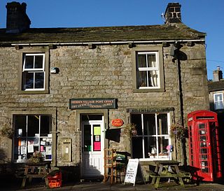
Hebden is a village and civil parish in the former Craven District of North Yorkshire, England, and one of four villages in the ecclesiastical parish of Linton. It lies near Grimwith Reservoir and Grassington, in Wharfedale in the Yorkshire Dales National Park. In 2011 it had a population of 246.

<span class="mw-page-title-main">Otterburn, North Yorkshire</span> Village and civil parish in North Yorkshire, England

Otterburn is a village and civil parish in the Craven district of North Yorkshire, England. It is at OS Grid Reference SD8857, near Airton, Calton and the A65. The village is 9 miles (14 km) north west of Skipton and 1.9 miles (3 km) east of Hellifield.

<span class="mw-page-title-main">Castley</span> Village and civil parish in North Yorkshire, England

Castley is a village and civil parish in the former Harrogate district of North Yorkshire, England. It lies on a bend in the River Wharfe about 10 miles (16 km) north of the centre of Leeds. The population of the civil parish was estimated at 70 in 2015. The village appears in the Domesday Book as Castleai, a combination of castel, and lēah, meaning the clearing near the fort.

<span class="mw-page-title-main">Yorkshire Dales Railway</span> Railway line in North Yorkshire, England

The Yorkshire Dales Railway was a branch line linking the town of Skipton with the villages of Rylstone, Threshfield and Grassington in North Yorkshire, England. There were two stations on the line – Grassington & Threshfield and Rylstone – and a connection via the Skipton to Ilkley Line to Skipton.

<span class="mw-page-title-main">Barden Tower</span> Medieval building in North Yorkshire, England

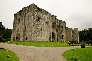
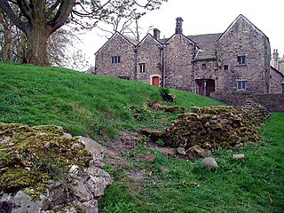
Barden Tower is a ruined building in the Parish of Barden, in Wharfedale, North Yorkshire, England. The tower was used as a hunting lodge in the 15th and 16th centuries, and despite a renovation in the 1650s, it fell into disrepair in the 18th century. The tower is now part of the Bolton Estate and is listed as a medieval fortified tower. Along with other buildings on the Bolton Estate, it is a focal point and many people visit the tower. It is also a way marker on the 100-mile (160 km) Lady Anne's Way long distance path.

<span class="mw-page-title-main">Nesfield</span> Village in North Yorkshire, England

Nesfield is a small village, 2 miles (3.2 km) north-west of Ilkley on the north bank of the River Wharfe, in the civil parish of Nesfield with Langbar, in the Harrogate district, in the county of North Yorkshire, England. Historically in the West Riding of Yorkshire, the village sits at the southern edge of the Nidderdale Area of Outstanding Natural Beauty.

<span class="mw-page-title-main">Skirethorns</span> Hamlet in North Yorkshire, England

Skirethorns is a hamlet in the civil parish of Threshfield, in Wharfedale, North Yorkshire, England. The hamlet is just west of the village of Threshfield, in the Yorkshire Dales National Park, some 6 miles (9.7 km) south of Kettlewell, and 8 miles (13 km) north of Skipton. Threshfield Quarry is located north-west of the hamlet, and despite its name, it is located in Skirethorns.

References

  1. 1 2 "Parish Mid-year Population Estimates 2015". Data North Yorkshire.
  2. 1 2 "Postcode Finder". Royal Mail . Archived from the original on 26 November 2024.
  3. James, A. Lloyd (1930). Broadcast English: Recommendations to Announcers Regarding the Pronunciation of Some English Place Names. BBC. p. 37.
  4. "Key to English Place-names". kepn.nottingham.ac.uk. Retrieved 17 December 2024.
  5. "Draughton". Survey of English Place-Names. English Place-Name Society.
  6. 1 2 3 4 5 "Map of planning data for England". planning.gov.uk.
  7. "Embsay & Bolton Abbey Steam Railway | Great Rail Journeys". Escorted Group Tours & Rail Holidays Experts | Great Rail Journeys. Retrieved 29 October 2024.
  8. "Draughton". explore.osmaps.com. Ordnance Survey . Retrieved 9 November 2024.
  9. "Calling for a cuppa". www.churchtimes.co.uk. Retrieved 13 January 2025.
  10. Tate, Lesley (29 August 2024). "New traffic free route at Draughton helps Dales Way walkers". Craven Herald. Retrieved 15 October 2024.
  11. "BGS Geology Viewer – The Geological Map Viewer of Britain". geologyviewer.bgs.ac.uk. Retrieved 16 October 2024.
  12. "Draughton CP/Tn through time | Population Statistics | Total Population". www.visionofbritain.org.uk. University of Portsmouth. Retrieved 26 October 2024.
  13. "Draughton | Domesday Book". opendomesday.org. Retrieved 17 December 2024.
  14. "Draughton – Airedale & Wharfedale Family History Society" . Retrieved 17 October 2024.
  15. "Exclusive: Post Office accused of branch closures by stealth". Yorkshire Post. 2 September 2013. Retrieved 13 January 2025.
  16. "Popular Bradford district tourist spot had highest level of poo in water tests". Bradford Telegraph and Argus. 6 May 2024. Retrieved 15 October 2024.
  17. "Ilkley River Wharfe bathing site gets upstream UV treatment". 8 June 2022. Retrieved 15 October 2024.
  18. "Parish Council | Draughton" . Retrieved 27 October 2024.
  19. "Boundary review 2023: Which seats will change in the UK?". UK Parliament. 20 March 2024.