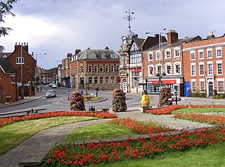
West Midlands is a metropolitan and ceremonial county in the larger West Midlands region of England. A landlocked county, it is bordered by Staffordshire to the north and west, Worcestershire to the south, and is surrounded by Warwickshire to the east. The largest settlement is the city of Birmingham.

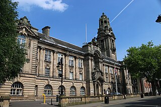
Walsall is a market town and administrative centre of the borough of the same name in the West Midlands, England. Historically part of Staffordshire, it is located 9 miles (14 km) northwest of Birmingham, 7 miles (11 km) east of Wolverhampton and 9 miles (14 km) southwest of Lichfield.

Aldridge is a town in the Metropolitan Borough of Walsall in the West Midlands, England. It is historically, a village that was part of Staffordshire until 1974. The town is 3 miles (4.8 km) from Brownhills, 5 miles (8 km) from Walsall, 6 miles (9.7 km) from Sutton Coldfield and 7 miles (11 km) from Lichfield. The town is also the second-largest town in the Walsall Borough.

Sutton Coldfield or the Royal Town of Sutton Coldfield ( ), is a town and civil parish in the city of Birmingham, West Midlands, England. The town lies around 8 miles northeast of Birmingham city centre, 9 miles south of Lichfield, 7 miles southwest of Tamworth, and 7 miles east of Walsall.

Brownhills is a historic market and industrial town in the Metropolitan Borough of Walsall of the West Midlands, England. The town is located south of Cannock Chase and close to the large Chasewater reservoir, it is 6 miles (9.7 km) northeast of Walsall, a similar distance southwest of Lichfield and 13 miles (20.9 km) miles north-northwest of Birmingham. It is part of the Aldridge-Brownhills parliamentary constituency and neighbours the villages of Pelsall and Walsall Wood. It lies within the boundaries of the historic county of Staffordshire.

The Metropolitan Borough of Walsall is a metropolitan borough in the West Midlands, England. It is named after its largest settlement, Walsall, but covers a larger area which also includes Aldridge, Bloxwich, Brownhills, Darlaston, Pelsall and Willenhall.

Aldridge-Brownhills is a constituency in the West Midlands, represented in the House of Commons of the UK Parliament. It has been represented since 2015 by Wendy Morton, a Conservative.

Stonnall is a village in Staffordshire, England, close to Shenstone, Brownhills, Walsall Wood and Aldridge. It is divided into Upper Stonnall, Stonnall and Lower Stonnall — Upper Stonnall partly lies in the Metropolitan Borough of Walsall; the remainder of the village is in the district of Lichfield.

Shenstone is a village and civil parish in The Lichfield District, Staffordshire, England, located between Lichfield and Sutton Coldfield. The parish also contains the village of Stonnall.

Pelsall is a village in the Metropolitan Borough of Walsall, West Midlands, England. Forming part of the borough's border with Staffordshire, Pelsall is located 4 miles north of Walsall, midway between the towns of Bloxwich and Brownhills and 4 miles northwest of Aldridge. The southern edge of Cannock Chase is 6 miles to the north. Pelsall is also 8 miles southwest of Lichfield and 8 miles northeast of Wolverhampton.

Rushall is a historic village in the Metropolitan Borough of Walsall in the West Midlands county of England. It is centred on the main road between Walsall and Lichfield. It is mentioned in the Domesday Book but has mostly developed since the 1920s. Rushall was historically a part of the county of Staffordshire before it was incorporated with much of the old Aldridge-Brownhills Urban District into the modern-day Walsall district.

High Heath is an area of Shelfield in the Metropolitan Borough of Walsall in the West Midlands county of England. It is located to the northeast of Walsall and west of Aldridge. It is immediately adjoined to the villages of Pelsall and Shelfield. The area consists mostly of residential estates and home to a small shopping precedent on Spring Lane. As well as two churches on Mill Road and Green Lane. Also nearby is a former Primitive Methodist Church on Coronation Road/Broad Way, this is now a private residence.

Walsall Council, formally Walsall Metropolitan Borough Council, is the local authority for the Metropolitan Borough of Walsall in the West Midlands, England. The town of Walsall had been a borough from medieval times, which was reformed on numerous occasions. Since 1974 the council has been a metropolitan borough council. It provides the majority of local government services in the borough. The council has been a member of the West Midlands Combined Authority since 2016.

Muckley Corner is a small village and area of Hammerwich in Lichfield District of Staffordshire, England. The village is located on the A5 road/Watling Street and borders the Walsall Metropolitan Borough in the West Midlands County and Lichfield District in Staffordshire.

Stubber's Green is a settlement in the Walsall district, in the West Midlands county of England. It is located to the northeast of Walsall and west of Aldridge. It is immediately adjoined to the villages of Shelfield and Walsall Wood. The area is home to Stubbers Green Bog, an area of scientific importance. The area is mostly industrial and residential. It is also home to Aldridge Lake and the Swan Pool and the Swag, which are two lakes that pass under Stubber's Green Road between Shelfield and Aldridge, effectively dividing the two lakes/ponds.

Vigo is an area of Walsall Wood in the Metropolitan Borough of Walsall in the West Midlands county of England. It is located to the northeast of both Aldridge and Walsall. It is located between Aldridge and Walsall Wood. It is also bordered by the Daw End Branch Canal, separating it from the nearby villages of Shelfield and Pelsall. It is mostly made up of housing estates.

Shire Oak is a suburb of Brownhills, in the Walsall district, in the county of the West Midlands, England. The area is close to Walsall Wood and is at a crossroads between the A452/Chester Road to Birmingham and the A461/Lichfield Road between Lichfield and Walsall. It is also close to the Staffordshire boundary with Stonnall and Muckley Corner. The area is also home to Shire Oak Academy.

Sandhills is a hamlet near Brownhills in the Metropolitan Borough of Walsall in the West Midlands county of England. It is located on the A461 road between Lichfield and Walsall, where the boundary between West Midlands county to the north west and Staffordshire to the south east follows the rear boundaries of the properties along Lichfield Road at Sandhills, including the hamlet in Walsall and the West Midlands. It is also close to the Shire Oak suburb of Brownhills and the village of Stonnall.


