
Manitoulin District is a district in Northeastern Ontario within the Canadian province of Ontario. It was created in 1888 from part of the Algoma District. The district seat is in Gore Bay.

Gillam is a town on the Nelson River in northern Manitoba, Canada. It is situated between Thompson and Churchill on the Hudson Bay Railway line.
St. Louis is a village in the Canadian province of Saskatchewan within the Rural Municipality of St. Louis No. 431 and Census Division No. 15. It is south of the City of Prince Albert and northeast of Batoche.

Little Grand Rapids is a community in east central Manitoba, Canada, near the Ontario border. It is located approximately 280 kilometers or 173 miles north-northeast from Winnipeg, Manitoba.
Grandview is an unincorporated urban community in the Grandview Municipality within the Canadian province of Manitoba that held town status prior to January 1, 2015. It is located 45 kilometres west of the City of Dauphin along the Valley River. Grandview Manitoba is home to NHL's Ryan Pulock.
Brochet is an unincorporated community located in Northern Manitoba on the northern shore of Reindeer Lake near the Saskatchewan border; it is designated as a northern community.
Camperville is a community in the Canadian province of Manitoba.
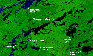
Cross Lake is a community in the Northern Region of the Canadian province of Manitoba, situated on the shores of the Nelson River where the river enters the namesake Cross Lake. An all-weather road, PR 374, connects the communities to PR 373 via the Kichi Sipi Bridge.
The Pine Creek First Nation is a Saulteaux First Nation in Manitoba, Canada. The First Nation's homeland is the Pine Creek 66A reserve, located approximately 110 kilometres north of Dauphin along the southwestern shore of Lake Winnipegosis between the communities of Camperville and Duck Bay. The Rural Municipality of Mountain (South) borders it on the southwest.
Powerview-Pine Falls is a town in the Canadian province of Manitoba, with a population of 1,314 at the 2011 census, up 1.54% from 1,294 at the 2006 census and down 7.57% from 1,400 during the 2001 census.
Deadman's Bay is a local service district and designated place in the Canadian province of Newfoundland and Labrador. It is on the Straight Shore of Bonavista Bay near the community of Lumsden. The community is located near fishing grounds, contributing to its diversified and successful fishery despite its exposed, sandy coastline and harsh fall storms.
Lumsden, formerly known as Cat Harbour, is a community located on the Straight Shore of Newfoundland in Newfoundland and Labrador, Canada, near communities such as Musgrave Harbour and Newtown. Lumsden formerly consisted of two settlements, Lumsden North on the tip of a sandy peninsula and Lumsden South on the main road. Although the harbour in Lumsden is not ideal because it is not sheltered, Lumsden has excellent fishing grounds.
Churchbridge is a town in the province of Saskatchewan, Canada, located at the junction of the Yellowhead Highway, and Highway 80. Churchbridge is a part of the Rural Municipality of Churchbridge No. 211, which is located within Saskatchewan Association of Rural Municipalities (SARM) Division No. 1 and census division Number 5.

The Rural Municipality of Mountain is a rural municipality (RM) in the Parkland Region of Manitoba, western Canada.

Berens River is a community in Manitoba, Canada, along the eastern shore of Lake Winnipeg, at the mouth of the Berens River, which flows west from the Ontario headwaters. Together with the adjacent Berens River 13 reserve, it forms one a population centre collectively called Berens River. Both are served by the Berens River Airport.

Ninette is an unincorporated community recognized as a local urban district located in Manitoba, Canada at the north end of Pelican Lake. It is located in the Rural Municipality of Prairie Lakes. Ninette has many small businesses, and is known locally for its wide range of sports facilities. In the summer, activities such as boating, fishing, and hunting are offered, while snowmobiling and ice fishing are offered during the wintertime.
Dawson Bay is a community in the Canadian province of Manitoba.

The Rural Municipality of Ellice-Archie is a rural municipality (RM) in the Canadian province of Manitoba.

Grandview Municipality is a rural municipality (RM) in the Parkland Region of Manitoba, Canada. It is located in a valley between Duck Mountain Provincial Forest & Park and Riding Mountain National Park, which both lie partially within the RM's territory.
