Duffins Creek

Last updated
Duffins Creek
West Duffins Creek.jpg
Headwaters of the West Duffins Creek, Rouge National Urban Park
Canada Southern Ontario relief location map.jpg
Red pog.svg
Location of the mouth of the Duffins Creek in southern Ontario
Location
Country Canada
Province Ontario
Area Greater Toronto Area
Region Regional Municipality of Durham
Municipalities
Physical characteristics
SourceConfluence of several branches of Duffins Creek and tributaries
  location Uxbridge (Goodwood and Glen Major)
Stouffville (Bloomington and Lincolnville)
Mouth Duffins Marsh at Lake Ontario
  location
Ajax
  coordinates
43°49′00″N79°02′05″W / 43.8167°N 79.0348°W / 43.8167; -79.0348
Basin size287 km2 (111 sq mi) [1]
Discharge 
  average1.38 m3/s (49 cu ft/s) [2]
  minimum0.51 m3/s (18 cu ft/s)
  maximum3.67 m3/s (130 cu ft/s)
Basin features
River system Great Lakes Basin

Duffins Creek is a waterway in the eastern end of the Greater Toronto Area in Ontario, Canada. The watershed of the Duffins Creek is part of the Durham Region (Uxbridge, Pickering and Ajax) and the York Region (Markham and Whitchurch-Stouffville). [3]

Contents

Etymology and names

Augustus Jones, who surveyed the area for the Government of Upper Canada in 1791, states that the native (Mississauga Anishinaabek) name for the stream was Sin-qua-trik-de-que-onk, meaning "pine wood on side". [4] The Ojibwe Mississauga name of the creek in modern orthography is Zhingwaatigotigweyaa-ziibi. [5]

The French missionaries from Ganatsekwyagon, who reached the stream in 1670, called it Riviere au Saumon, meaning the "Salmon River", because of a large number of salmon fish that spawned there. [6]

Jones named the stream after Mike Duffin, the first person of European descent to settle in the area. [7] [8] The current name of the stream first appears as "Duffin" on Jones' map in 1791; subsequent records mention the variants "Duffin's" and "Duffins". [9]

History

The Duffins Creek watershed includes 192 archaeological sites tracked using the Borden System. These sites represent both indigenous peoples and early European settlers. [10]

Number of archaeological sites in the Duffins Creek Watershed [10]
Stream Paleo-Indian Archaic Woodland Undermined Aboriginal Mississauga Multi-componentEuro-CanadianUndeterminedTotal
Stouffville Creek1113
Reesor Creek22610
West Duffins113563661
Wixon Creek112
Mitchell Creek311813
East Duffins2252521542
Major Creek3311118
Whitevale Creek0
Ganatsekiagon Creek2731417
Urfé Creek2226
Brougham Creek32510
Millers Creek114410
Total530303912679192

Projectile points of "Hi-Lo" style have been discovered at four Late Paleo-Indian (10000-7000 BCE) sites in the Duffins Creek watershed. Around Lake Ontario, the indigenous peoples have been commonly associated with the lake shore, which fluctuated because of the melting glaciers. At the end of the Last Glacial Period, the Duffins Creek met Lake Ontario at a point located 10-20 m below the present surface level. So, any evidence of indigenous activity at the mouth of the Duffins Creek would be under water now. [11]

Scattered remains of chert (flint) tools and flakes have been discovered at several inland sites dated to the Archaic period (7000 BCE-1000 BCE). Detailed excavactions have not been carried out at these sites, so little information is available about the pre-historic residents of the area. [12]

Several sites dated to the early and middle Woodland period (1000 BCE-700 CE) exist along the Duffins Creek, but not much research has been done on them. [13] The sites from the Late Woodland period (700-1651 CE) indicate the existence of permanent villages that were occupied for 5-30 years. Some of the Iroquoian villages were 3-10 acres in size, and featured longhouses and palisades. The largest site from this period in the Duffins Creek watershed is the Draper Site, which was excavated during the 1970s for the proposed Pickering Airport. [14]

In the mid-17th century, the Iroquois people displaced the Petun and the Wendat (Huron) from what is now southern Ontario. The Iroquois Seneca people established river-side villages in nearby areas, such as Ganatsekwyagon on Rouge and Teiaiagon on Humber. [15] However, the Duffins Creek was not as attractive for building a settlement, because a sand bar at its mouth prevented boats from entering it. Moreover, it was navigable for canoes only for 6 km upstream. [9] When the Europeans arrived in present-day Ajax, at least one Ojibwe family resided in area, as attested by Arthur Field. This family lived at the east edge of the Duffins Creek marshes until the mid-19th century. [8]

Unlike the Rouge River watershed, where a well-established trail ran along the stream, the Duffins Creek watershed remained largely ignored by the early European visitors in the area. [15] In 1670, French missionaries from Ganatsekwyagon reached the Duffins Creek, but did not settle there. [6]

In the 1770s, Mike Duffin, an Irish fur trader, became the first person of European descent to settle in the Duffins Creek area. He built a cabin on the east side of the Creek, north of a trail that later became the Kingston Road. [7] [8] At the beginning of the 19th century, the Duffins Creek was navigable as far up as Kingston Road. [16] Later, the water flow decreased as a result of construction of mill dams and clearing of forests for farming. The dams also cut off the salmon from their spawning grounds. [6] Pickering Village, a settlement initially known as "Duffins Creek", developed along the stream, in what is now Ajax. The first mill in the new settlement was established in 1810 by Timothy Rogers on the banks of Duffins Creek. At the time of Rogers's arrival, thousands of salmon from Lake Ontario came to the Duffins Creek. By the time of his death in 1834, the salmon had practically disappeared from the stream. [17]

The growth of Pickering Township (which included Pickering Village) was slow compared to the other parts of Greater Toronto Area, because much of the land was held by absentee landlords (such as the Smith family), or held as Crown and Clergy reserves. Apart from Pickering Village, several other communities developed in the Duffins Creek watershed in the early 19th century: [18]

During 1825-1900, population of the Duffins Creek watershed increased substantially because of growth in farming and other businesses. After 1850s, several smaller communities declined as people migrated to larger centres located along the Grand Trunk Railway. Pickering Village and Stoufville, where several mills had earlier been established and which were now accessible by railway, emerged as the major population centres of the area. The community around the DIL munitions plant evolved into the town of Ajax in the mid-20th century. The northern part of the Duffins Creek watershed did not develop as rapidly as other watersheds in the Greater Toronto area, because the Government of Canada marked a large portion of land for the proposed Pickering Airport. [19]

Course

The headwaters of the Duffins Creek are located in the Oak Ridges Moraine area, [20] within the boundaries of Uxbridge, Pickering, Markham, and Whitchurch-Stouffville. The mouth of the stream is located in Ajax. [15]

The Duffins Creek drains an area of 283 sq. km., much of which is owned by the government. The federal government owns around 75 sq. km., the provincial government of Ontario owns around 28 sq. km., and the Toronto and Region Conservation Authority (TRCA) owns around 23 sq. km. [20]

List of tributaries

Although Duffins Creek is a single waterway entering Lake Ontario at Duffins Marsh in Ajax, there are 12 other waterways that branches off Duffins towards the Oak Ridges Moraine. [21]

The main tributaries of Duffins Creek include: [22]

See also

Related Research Articles

<span class="mw-page-title-main">Ajax, Ontario</span> Town in Ontario, Canada

Ajax is a waterfront town in Durham Region in Southern Ontario, Canada, located in the eastern part of the Greater Toronto Area.

<span class="mw-page-title-main">Pickering, Ontario</span> City in Ontario, Canada

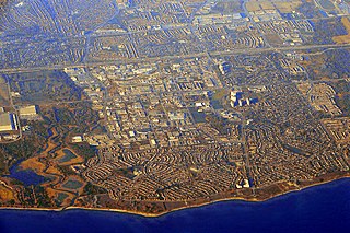
Pickering is a city located in Southern Ontario, Canada, immediately east of Toronto in Durham Region.

<span class="mw-page-title-main">Regional Municipality of York</span> Regional municipality in Ontario, Canada

The Regional Municipality of York, also called York Region, is a regional municipality in Southern Ontario, Canada, between Lake Simcoe and Toronto. The region was established after the passing of then Bill 102, An Act to Establish The Regional Municipality of York, in 1970. It replaced the former York County in 1971, and is part of the Greater Toronto Area and the inner ring of the Golden Horseshoe. The regional government is headquartered in Newmarket.

<span class="mw-page-title-main">Whitchurch-Stouffville</span> Town in Ontario, Canada

Whitchurch-Stouffville is a town in the Greater Toronto Area of Ontario, Canada, approximately 50 km (31 mi) north of downtown Toronto, and 55 km (34 mi) north-east of Toronto Pearson International Airport. It is 206.22 km2 (79.62 sq mi) in area, and located in the mid-eastern area of the Regional Municipality of York on the ecologically-sensitive Oak Ridges Moraine. Its motto since 1993 is "country close to the city".

<span class="mw-page-title-main">Rouge River (Ontario)</span> River in Ontario, Canada

The Rouge River is a river in Markham, Pickering, Richmond Hill and Toronto in the Greater Toronto Area of Ontario, Canada. The river flows from the Oak Ridges Moraine to Lake Ontario at the eastern border of Toronto, and is the location of Rouge Park, the only national park in Canada within a municipality. At its southern end, the Rouge River is the boundary between Toronto and southwestern Pickering in the Regional Municipality of Durham.

Stouffville is the primary urban area within the town of Whitchurch-Stouffville in York Region, Ontario, Canada. It is situated within the Greater Toronto Area and the inner ring of the Golden Horseshoe. The urban area is centred at the intersection of Main Street, Mill Street, and Market Street. Between 2006 and 2011, the population of the Community of Stouffville grew 100.5% from 12,411 to 24,886, or from 51% to 66% of the total population of the larger town of Whitchurch-Stouffville. The population of Stouffville from the 2021 census is 36,753.

The Toronto and Region Conservation Authority (TRCA) is a conservation authority in southern Ontario, Canada. It owns about 16,000 hectares of land in the Toronto region, and it employs more than 400 full-time employees and coordinates more than 3,000 volunteers each year. TRCA's area of jurisdiction is watershed-based and includes 3,467 square kilometres (1,339 sq mi) – 2,506 on land and 961 water-based in Lake Ontario. This area comprises nine watersheds from west to east – Etobicoke Creek, Mimico Creek, Humber River, Don River, Highland Creek, Petticoat Creek, Rouge River, Duffins Creek and Carruthers Creek.

<span class="mw-page-title-main">Rouge National Urban Park</span> National urban park in Ontario, Canada

Rouge National Urban Park is a national urban park in Ontario, Canada. The park is centred around the Rouge River and its tributaries in the Greater Toronto Area. The southern portion of the park is situated around the mouth of the river in Toronto, and extends northwards into Markham, Pickering, Uxbridge, and Whitchurch-Stouffville.

Dickson Hill is a small community in northeast Markham, Ontario, Canada, located near Highway 48 and 19th Avenue, on the border to Whitchurch-Stouffville.

Pickering Village is a former municipality and now a neighbourhood in the town of Ajax, within the Durham Region of Ontario, Canada. The Pickering Village derives its name from the former Pickering Township, which included the present-day town of Ajax and the city of Pickering. A small portion of the original settlement is now part of the Village East neighbourhood in the city of Pickering.

<span class="mw-page-title-main">Altona, Ontario</span> Unincorporated community in Ontario, Canada

Altona is a ghost town located in Pickering, Ontario, at Sideline 30 and the Pickering-Uxbridge Town Line. It is just east of Whitchurch-Stouffville, and was named after Altona, now a borough of Hamburg, Germany.

<span class="mw-page-title-main">Locust Hill, Ontario</span> Unincorporated community and former hamlet in Ontario, Canada

Locust Hill is a historic community of Markham, Ontario centred on Hwy. 7 and the Canadian Pacific Railway and within the boundaries of the future national Rouge Park.

Mongolia is an historical community in Markham, Ontario centred on 10th Line and Elgin Mills Rd. East, immediately south of the Town of Whitchurch-Stouffville. The hamlet lies completely within the expropriated federal Pickering Airport lands and also within the proposed boundaries of a future national Rouge Park.

<span class="mw-page-title-main">Ringwood, Ontario</span> Unincorporated community in Ontario, Canada

Ringwood is a hamlet in York Region, Ontario, Canada, in the Town of Whitchurch–Stouffville. The hamlet is centred at the intersection of Stouffville Road and Highway 48, on the Little Rouge River, a tributary of the Rouge River on the Oak Ridges Moraine. The community originally straddled the townships of Markham and Whitchurch in the County of York. The hamlet was named Ringwood in 1856 by George Sylvester, postmaster and owner of a general store, after the town of Ringwood, in Hampshire, England. It was first settled in the 1790s by George Fockler from Pennsylvania. The Little Rouge River runs along the eastern edge of the hamlet. In 1857, Ringwood had a population of 200 which grew only slightly to 225 by 1910. By 1972, the population had dropped to 172. Between 2008 and 2010, more than 250 homes were constructed in Ringwood's Cardinal Point subdivision north of Main Street. Construction on a new auto mall in Ringwood began in 2009, with Hyundai and Toyota dealerships opening in 2010, and Dodge/Jeep and Nissan dealerships constructed in 2013.

<span class="mw-page-title-main">Mantle Site</span> Remains of an indigenous village

The "Jean-Baptiste Lainé" or Mantle Site in the town of Whitchurch–Stouffville, north-east of Toronto, Ontario, Canada, is the largest and most complex ancestral Wendat-Huron village to be excavated to date in the Lower Great Lakes region. The site's southeastern access point is at the intersection of Mantle Avenue and Byers Pond Way.

<span class="mw-page-title-main">Abraham Stouffer</span>

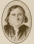
Abraham Stouffer is the founder of the town of Stouffville, Ontario.

<span class="mw-page-title-main">Peter Reesor</span>

Peter Reesor was one of the original settlers of Markham, Ontario.

<span class="mw-page-title-main">Petticoat Creek</span> River in Ontario, Canada

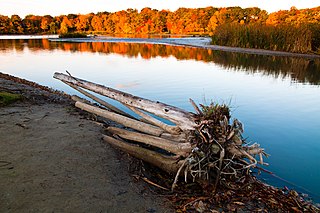
Petticoat Creek is a stream in the cities of Pickering, Toronto and Markham in the Greater Toronto Area of Ontario, Canada. The creek is in the Great Lakes Basin, is a tributary of Lake Ontario, and falls under the auspices of the Toronto and Region Conservation Authority. Its watershed covers 26.77 square kilometres (10.34 sq mi), and the cumulative length of all its branches is 49 kilometres (30 mi). Land use in the watershed consists of 52% agricultural, 27% protected greenspace and 21% urban.

<span class="mw-page-title-main">Carruthers Creek (Canada)</span> River in Ontario, Canada

The Carruthers Creek is a stream in the Durham Region of Ontario, Canada. Its watershed lies within the boundaries of Pickering and Ajax.

The town of Ajax, Ontario in Canada evolved out of the Defence Industries Limited Pickering Works munitions plant built during the World War II, but its history begins much earlier.

References

  1. "Duffins Creek Watershed - Report Card 2013" (PDF). Toronto and Region Conservation Authority (TRCA). 2013. Retrieved 2022-07-17.
  2. Technical Reports in Support of the Duffins Creek and Carruthers Creek Watershed Plan
  3. TRCA 2002, p. 2.
  4. TRCA 2003, p. 36.
  5. "Zhingwaatigotigweyaa-ziibi". Ojibwe - English Dictionary. Retrieved 2022-07-17.
  6. 1 2 3 Ken Smith 1995, p. 115.
  7. 1 2 Ken Smith 1995, pp. 115–116.
  8. 1 2 3 Rob Nisbet 1995, p. 18.
  9. 1 2 Harold H. Harvey 2011, p. 286.
  10. 1 2 TRCA 2002, pp. 3–4.
  11. TRCA 2002, pp. 9–10.
  12. TRCA 2002, p. 10.
  13. TRCA 2002, p. 11.
  14. TRCA 2002, p. 12.
  15. 1 2 3 TRCA 2002, p. 13.
  16. Ken Smith 1995, p. 130.
  17. Ken Smith 1995, p. 118.
  18. TRCA 2002, pp. 14–15.
  19. TRCA 2002, pp. 15–17.
  20. 1 2 TRCA 2003, p. 33.
  21. TRCA 2002, p. 3.
  22. TRCA 2003, p. 33,170.

Bibliography