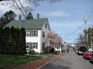
The Bradford–Union Street Historic District encompasses a waterfront residential area of Plymouth, Massachusetts, developed in the mid-19th for workers in local maritime and other industries. It is centered at the junction of Bradford and Union Streets, across Town Brook from downtown Plymouth. The district was added to the National Register of Historic Places in 1983.

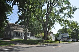
The East Blackstone Village Historic District is a historic district roughly along Elm Street at the junction with Summer Street in eastern Blackstone, Massachusetts. It encompasses a small 19th-century mill village center that developed along what was once a major roadway connecting Worcester with Providence, Rhode Island. The district was added to the National Register of Historic Places in 1995.

The Lunenburg Historic District is a historic district encompassing the historic center of Lunenburg, Massachusetts. The district is centered on a stretch of Main Street which connects two triangular intersections. It includes many of the town's oldest buildings, including the c. 1724 Cushing House, and the c. 1730 Stillman Stone House. Three of the town's most significant institutional buildings were built before 1850: the town hall, the Congregational church, and the Methodist church. The district was added to the National Register of Historic Places in 1988.

The Acushnet Heights Historic District is a predominantly residential historic district in central New Bedford, Massachusetts. It encompasses a densely-built urban area about 20 acres (8.1 ha) in size, which was developed as a working-class area, beginning in the 1860s, for the many workers in the city's factories. The district was listed on the National Register of Historic Places in 1989. It abuts the North Bedford Historic District, which is just to the south, and includes the following separately-listed properties: the Union Street Railway Carbarn, the Bradford Smith Building, and the Dawson Building.

The Cotuit Historic District is a historic district encompassing the heart of the village of Cotuit in Barnstable, Massachusetts. It extends along Main Street from Lowell Street in the north to Sea Street in the south, and includes portions of Ocean View Avenue and properties on adjacent roads. The oldest properties date to the late 18th century, but saw its greatest development during the height of the area's maritime industry in the mid 19th century. In the late 19th and early 20th century the area saw new development as a summer resort area. The district was listed on the National Register of Historic Places in 1987.

The Five Corners Historic District is a historic district encompassing the central district of the village of South Williamstown, Massachusetts. It is centered at the junction of Cold Spring, Green River, New Ashford. The junction has been a prominent center in the area since 1760. Prominent buildings in the district include the South Center School, the Store at Five Corners, and the Second Congregational Church. The district was listed on the National Register of Historic Places in 1993.
The Elm Street Historic District is a rural historic district in southern Hatfield, Massachusetts. It encompasses a landscape that has seen agricultural use since 17th century colonial days, including fields now used for tobacco farming, and historic properties located along five roads: Elm Street, Scotland Road, Sunset Road, Brook Hollow Road, and Little Neponset Road. The district is bounded on its south by the Connecticut River, on its east and north by the Mill River, with a small portion of land border in the northeast which cuts off a large meander in the river. This section, near the junction of Elm and Prospect Streets, is also where this district abuts the Mill-Prospect Street Historic District, which runs north along Prospect Street, and its eastern boundary abuts the Hatfield Center Historic District. Its western boundary is roughly a north-south line in the area of the junction of Elm and Dwight Streets.

The Hadley Center Historic District is an expansive, 2,500-acre (1,000 ha) historic district encompassing the village center of Hadley, Massachusetts. When it was first listed on the National Register of Historic Places in 1977, the district encompassed the town green and 17 buildings that faced it, at the junction of Russell Street and Middle Street. The district was expanded significantly in 1994, adding more than 400 buildings representative of the village's growth from colonial days into the first decades of the 20th century. This expansion encompasses the entirety of a tongue of land extending west from East Street and bounded by a bend in the Connecticut River, which separates Hadley from Northampton. Its oldest property, the Samuel Porter House on West Street, was built in 1713.
The South Amherst Common Historic District encompasses the village common and surrounding buildings of South Amherst, Massachusetts. This area developed as a rural residential village hub in the 18th and 19th centuries. It was listed on the National Register of Historic Places in 1995.

The Upper Worthington Historic District of Springfield, Massachusetts encompasses a collection of visually cohesive residential apartment blocks that represent one of the largest residential developments in the city dating to the first three decades of the 20th century. It is centered on a portion of Worthington Street, a major east-west road in the city, between Armory Street and Summit Street, and includes 33 buildings on those three streets as well as Federal and Taylor Streets, near their junctions with either Worthington or Federal. Most of the contributing buildings are four story brick buildings with Georgian detailing and stone trim. The district was first listed on the National Register of Historic Places in 1983, including 28 buildings; the district was expanded in 1992 to add the five buildings on Taylor Street.

The Longmeadow Street–North Historic District encompasses a stretch of Longmeadow Street in northern Longmeadow, Massachusetts, from the town line with neighboring Springfield to Cooley and Westmoreland Streets in the south. It was listed on the National Register of Historic Places in 1994. The district's primarily residential architecture and streetscape is reflective of more than two centuries of development trends, and a late 19th-century desire to maintain a more rural atmosphere.

The Granville Village Historic District is a historic district encompassing the historic Granville Village area in eastern Granville, Massachusetts. The area was developed in the 19th century as an industrial village, centered on the drum factory of Noble & Cooley on Dickinson Brook. The predominantly residential district includes a number of Greek Revival houses; it also includes the Colonial Revival public library building. It is located roughly in the area around the junction of Maple St. and Main and Granby Rds., including part of Water Street. The district was listed on the National Register of Historic Places in 1991.

The West Granville Historic District is a historic district encompassing the center of West Granville, Massachusetts. The village is composed mainly of buildings form the late 18th and early 19th centuries, including an 18th-century church and 1830s academy building. The district was listed on the National Register of Historic Places in 1991.

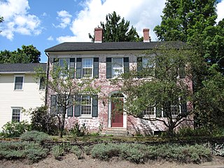
The Hamilton Historic District encompasses the early historic center of Hamilton, Massachusetts. It includes properties at 540-700 and 563-641 Bay Road, extending along the road from Orchard Road in the south to Cutler Road in the north. Numerous Greek Revival buildings are located within the district including the First Congregational Church of Hamilton, built in 1843. The district was added to the National Register of Historic Places in 1973.

Meetinghouse Green Historic District encompasses the historic 17th century heart of Ipswich, Massachusetts. The district runs along North Main Street, south from its junction with High Street to the southern end of the Meetinghouse Green. It was listed on the National Register of Historic Places in 1980.

The South Green Historic District encompasses one of the oldest central civic parts of Ipswich, Massachusetts. The town's South Green was laid out in 1686, and is now the heart of a collection of historic properties dating from the 17th to the 19th century. The centerpiece of the district is the green itself, and its most notable associated property is the John Whipple House, a National Historic Landmark and museum. The district boundaries extend from the junction of South Main and Elm Streets, southward past the green to where County Road crosses Saltonstall's Creek.

The Tavern Acres Historic District encompasses a residential development known as Tavern Acres, which was built in the 1920s with a landscape design by Henry Vincent Hubbard, then with the Olmsted Brothers landscape design firm. It is bounded by Bradstreet Rd., Green and Main Sts. and Park Way in North Andover, Massachusetts. The district encompasses Memorial Park, the Stevens Library, and properties facing Memorial Park and further along Bradstreet Road. The district was listed on the National Register of Historic Places in 1995.

The West Chesterfield Historic District is a historic district that encompasses the 19th century industrial and residential heritage of the village of West Chesterfield in the town of Chesterfield, Massachusetts. Centered at the junction of Main Road and Ireland Street, it was one of the town's main industrial sites for many years. The district was listed on the National Register of Historic Places in 2008.

The Jewell Town District of South Hampton, New Hampshire, encompasses a colonial-era industrial village with a history dating to 1687. It is centered at the junction of West Whitehall and Jewell Streets, which is just south of a bend in the Powwow River, the source of the power for the mills that were built here. The area was settled in 1687 by Thomas Jewell, and by the early 19th century included a variety of mills as well as a bog iron works. The district now includes only remnants of its industrial past, and features a collection of 18th and early-19th century residential architecture. The district was listed on the National Register of Historic Places in 1983.

The St. Johnsbury Historic District encompasses much of the historic civic and commercial center of St. Johnsbury, Vermont. Representing a significant expansion of the Railroad Street Historic District and the St. Johnsbury Main Street Historic District, it captures the historical tension and competition between Main Street and Railroad Street for primacy as the town's most important civic and commercial areas. The district was listed on the National Register of Historic Places in 1980.


