East Hawkesbury

Last updated

East Hawkesbury
Township of East Hawkesbury
Canton de Hawkesbury Est
Hwy 417 East Hawkesbury.JPG
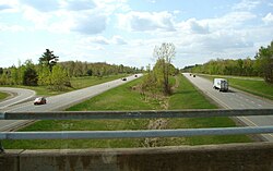
Highway 417 at East Hawkesbury
Prescott and Russell locator map 2021.svg
Red pog.svg
East Hawkesbury
Canada Southern Ontario location map 2.png
Red pog.svg
East Hawkesbury
Coordinates: 45°30′14″N74°30′00″W / 45.5039°N 74.5°W / 45.5039; -74.5
Country Canada
Province Ontario
County Prescott and Russell
IncorporatedJanuary 1, 1850
Government
  MayorRobert Kirby
  Federal riding Glengarry—Prescott—Russell
  Prov. riding Glengarry—Prescott—Russell
Area
[1]
  Land235.06 km2 (90.76 sq mi)
Population
 (2021) [1]
  Total
3,418
  Density14.5/km2 (38/sq mi)
Time zone UTC-5 (EST)
  Summer (DST) UTC-4 (EDT)
Postal Code FSA
K0B
Area code(s) 613, 343, 450, 579
Website www.easthawkesbury.ca OOjs UI icon edit-ltr-progressive.svg

East Hawkesbury is a township in eastern Ontario, Canada, in the United Counties of Prescott and Russell. Situated on the Ottawa River, its eastern boundary is the border with the province of Quebec.

Contents

Communities

The township comprises the villages of Chute-à-Blondeau, Sainte-Anne-de-Prescott and Saint-Eugène. The township administrative offices are located in Saint-Eugène. [2]

Demographics

In the 2021 Census of Population conducted by Statistics Canada, East Hawkesbury had a population of 3,418 living in 1,425 of its 1,507 total private dwellings, a change of 3.7% from its 2016 population of 3,296. With a land area of 235.06 km2 (90.76 sq mi), it had a population density of 14.5/km2 (37.7/sq mi) in 2021. [1]

Canada census – East Hawkesbury community profile
2021 2016 2011
Population3,418 (+3.7% from 2016)3,296 (-1.2% from 2011)3,335 (-1.0% from 2006)
Land area235.06 km2 (90.76 sq mi)235.01 km2 (90.74 sq mi)235.18 km2 (90.80 sq mi)
Population density14.5/km2 (38/sq mi)14.0/km2 (36/sq mi)14.2/km2 (37/sq mi)
Median age50.8 (M: 50.4, F: 51.2)49.8 (M: 50.3, F: 49.4)46.9 (M: 47.4, F: 46.4)
Private dwellings1,507 (total)  1,425 (occupied)1,482 (total) 1,386 (total) 
Median household income$81,000$66,752$66,310
References: 2021 [3] 2016 [4] 2011 [5]
Historical census populations – East Hawkesbury
YearPop.±%
1871 4,611    
1881 5,082+10.2%
1891 4,896−3.7%
1901 4,621−5.6%
1911 4,041−12.6%
1921 3,855−4.6%
1931 3,631−5.8%
1941 3,465−4.6%
YearPop.±%
1951 3,231−6.8%
1956 3,231+0.0%
1961 3,163−2.1%
1966 2,835−10.4%
1971 2,842+0.2%
1976 2,895+1.9%
1981 2,968+2.5%
1986 2,788−6.1%
YearPop.±%
1991 3,159+13.3%
1996 3,296+4.3%
2001 3,415+3.6%
2006 3,368−1.4%
2011 3,335−1.0%
2016 3,296−1.2%
2021 3,418+3.7%
Source: Statistics Canada [1] [6] [7]

See also

References

  1. 1 2 3 4
  2. "Mayor's Welcome :: East Hawkesbury Township". easthawkesbury.ca. Retrieved 2018-04-19.
  3. '"`UNIQ--templatestyles-00000017-QINU`"' "2021 Community Profiles". 2021 Canadian census . Statistics Canada. February 4, 2022. Retrieved 2023-10-19.
  4. '"`UNIQ--templatestyles-00000019-QINU`"' "2016 Community Profiles". 2016 Canadian census . Statistics Canada. August 12, 2021. Retrieved 2019-06-30.
  5. '"`UNIQ--templatestyles-0000001B-QINU`"' "2011 Community Profiles". 2011 Canadian census . Statistics Canada. March 21, 2019. Retrieved 2021-01-06.
  6. Eighth Census of Canada 1941 - Volume II - Population by Local Subdivisions (Report). Dominion Bureau of Statistics. 1944. CS98-1941-2.
  7. "1971 Census of Canada - Population Census Subdivisions (Historical)". Catalogue 92-702 Vol I, part 1 (Bulletin 1.1-2). Statistics Canada. July 1973.