Edgewater Park, Oklahoma | |
|---|---|
 Edgewater Park  Edgewater Park | |
| Coordinates: 34°49′29″N98°22′30″W / 34.82472°N 98.37500°W | |
| Country | United States |
| State | Oklahoma |
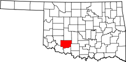
| County | Comanche |
| Area | |
• Total | 0.32 sq mi (0.82 km2) |
| • Land | 0.32 sq mi (0.82 km2) |
| • Water | 0 sq mi (0.00 km2) |
| Elevation | 1,266 ft (386 m) |
| Population (2020) | |
• Total | 262 |
| • Density | 823/sq mi (317.8/km2) |
| Time zone | UTC-6 (Central (CST)) |
| • Summer (DST) | UTC-5 (CDT) |
| ZIP Code | 73006 (Apache) |
| Area code | 580 |
| FIPS code | 40-23100 |
| GNIS feature ID | 2812847 [2] |
Edgewater Park is a census-designated place (CDP) in Comanche County, Oklahoma, United States. It was first listed as a CDP prior to the 2020 census. [2]
Contents
The CDP is in northern Comanche County, on high ground overlooking Lake Ellsworth from the west. It is less than 1 mile (1.6 km) east of U.S. Routes 62/281 at a point 16 miles (26 km) north of Lawton and 5 miles (8 km) south of Apache.
Lake Ellsworth is an impoundment on East Cache Creek, a south-flowing tributary of the Red River.