Lakeside Village, Oklahoma | |
|---|---|
 Lakeside Village  Lakeside Village | |
| Coordinates: 34°47′58″N98°22′26″W / 34.79944°N 98.37389°W [1] | |
| Country | United States |
| State | Oklahoma |
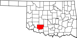
| County | Comanche |
| Area | |
• Total | 0.38 sq mi (0.98 km2) |
| • Land | 0.28 sq mi (0.73 km2) |
| • Water | 0.10 sq mi (0.26 km2) |
| Elevation | 1,263 ft (385 m) |
| Population (2020) | |
• Total | 162 |
| • Density | 575.3/sq mi (222.12/km2) |
| Time zone | UTC-6 (Central (CST)) |
| • Summer (DST) | UTC-5 (CDT) |
| ZIP Code | 73538 (Elgin) |
| Area code | 580 |
| FIPS code | 40-41050 |
| GNIS feature ID | 2812850 [1] |
Lakeside Village is a census-designated place (CDP) in Comanche County, Oklahoma, United States. It was first listed as a CDP prior to the 2020 census. [1]
Contents
The CDP is in northern Comanche County, on the west side of Lake Ellsworth, on the south side of its Chandler Creek inlet. It is bordered to the west by U.S. Routes 62/281 and is 14 miles (23 km) north of Lawton and 7 miles (11 km) south of Apache. Via U.S. Route 277, it is 7 miles west-northwest of Elgin.
Lake Ellsworth is an impoundment on East Cache Creek, a south-flowing tributary of the Red River.