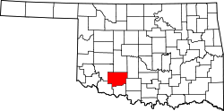
Fletcher, Oklahoma

Last updated

Fletcher, Oklahoma
OKMap-doton-Fletcher.PNG
Location of Fletcher, Oklahoma
Coordinates: 34°49′21″N98°14′26″W / 34.82250°N 98.24056°W / 34.82250; -98.24056
Country United States
State Oklahoma
County Comanche
Area
[1]
  Total1.94 sq mi (5.01 km2)
  Land1.92 sq mi (4.98 km2)
  Water0.01 sq mi (0.03 km2)
Elevation
[2]
1,401 ft (427 m)
Population
 (2020)
  Total1,204
  Density626.11/sq mi (241.69/km2)
Time zone UTC-6 (Central (CST))
  Summer (DST) UTC-5 (CDT)
ZIP code
73541
Area code 580
FIPS code 40-26350 [3]
GNIS feature ID2412632 [2]

Fletcher is a town in Comanche County, Oklahoma, United States. The population was 1,177 at the 2010 census. It is included in the Lawton, Oklahoma Metropolitan Statistical Area.

Contents

Geography

According to the United States Census Bureau, the town has a total area of 0.8 square miles (2.1 km2), all land.

Utilities

Telephone, Internet, and Digital TV Services are provided by Hilliary Communications.

Demographics

Historical population
CensusPop.Note
1910 374
1920 48228.9%
1930 73953.3%
1940 7896.8%
1950 87510.9%
1960 8841.0%
1970 9507.5%
1980 1,07413.1%
1990 1,002−6.7%
2000 1,0222.0%
2010 1,17715.2%
2020 1,2042.3%
U.S. Decennial Census [4]

As of the census of 2010, there were 1,177 people, 478 households, and 329 families residing in the town. The population density was 1,430.8 inhabitants per square mile (552.4/km2). There were 544 housing units at an average density of 661.3 per square mile (255.3/km2). The racial makeup of the town was 87.0% White, 1.9% African American, 5.1% Native American, 0.3% Asian, 0.7% from other races, and 4.8% from two or more races. Hispanic or Latino of any race were 4.1% of the population.

There were 478 households, out of which 30.8% had children under the age of 18 living with them, 56.3% were married couples living together, 9.4% had a female householder with no husband present, and 31.2% were non-families. 27.8% of all households were made up of individuals, and 14.6% had someone living alone who was 65 years of age or older. The average household size was 2.46 and the average family size was 2.97.

In the town, the population was spread out, with 25.7% under the age of 18, 7.8% from 18 to 24, 26.3% from 25 to 44, 22.9% from 45 to 64, and 17.2% who were 65 years of age or older. The median age was 37.3 years. For every 100 females, there were 85.4 males. For every 100 females age 18 and over, there were 84.4 males.

According to the 2000 census, the median income for a household in the town was $27,500, and the median income for a family was $34,028. Males had a median income of $28,594 versus $25,000 for females. The per capita income for the town was $13,329. About 14.0% of families and 14.4% of the population were below the poverty line, including 15.4% of those under age 18 and 15.6% of those age 65 or over.

Related Research Articles

<span class="mw-page-title-main">Steele, Alabama</span> Town in Alabama, United States

Steele is a town in northeastern St. Clair County, Alabama, United States. It was incorporated in 1952. At the 2010 census the population was 1,043, down from 1,093. The town is a part of the Birmingham–Hoover–Cullman Combined Statistical Area. It was initially known as Steel's Station or Steele's Depot in the late 19th century.

<span class="mw-page-title-main">Frenchville, Maine</span> Town in the state of Maine, United States

Frenchville is a town in Aroostook County, Maine, United States. The population was 1,052 at the 2020 census.

<span class="mw-page-title-main">Koshkonong, Missouri</span> City in Missouri, United States

Koshkonong is a city in Oregon County, Missouri, United States. The population was 196 at the 2020 census.

<span class="mw-page-title-main">Sarahsville, Ohio</span> Village in Ohio, United States

Sarahsville is a village in Noble County, Ohio, United States. The population was 147 at the 2020 census.

<span class="mw-page-title-main">Carter, Oklahoma</span> Town in Oklahoma, United States

Carter is a town in Beckham County, Oklahoma, United States. The population was 183 at the time of the 2020 census.

<span class="mw-page-title-main">Etowah, Oklahoma</span> Town in Oklahoma, United States

Etowah is a town in Cleveland County, Oklahoma, United States. The population was 159 at the 2020 census, a 72.8% increase from 2010.

<span class="mw-page-title-main">Indiahoma, Oklahoma</span> Town in Oklahoma, United States

Indiahoma is a town in Comanche County, Oklahoma, United States. It is located just south of US Route 62, about 24.4 driving miles west of Lawton.

<span class="mw-page-title-main">Amber, Oklahoma</span> Town in Oklahoma, United States

Amber is a town in Grady County, Oklahoma, United States. The population was 413 at the 2020 census, a 1.4% decrease from 2010.

<span class="mw-page-title-main">Bradley, Oklahoma</span> Town in Oklahoma, United States

Bradley is a town in Grady County, Oklahoma, United States. The population was 78 at the 2020 United States census.

<span class="mw-page-title-main">Ninnekah, Oklahoma</span> Town in Oklahoma, United States

Ninnekah is a town in Grady County, Oklahoma, United States. The population was 775 at the 2020 census, a 22.7% decrease from 2010.

<span class="mw-page-title-main">Pocasset, Oklahoma</span> Town in Oklahoma, United States

Pocasset is a town in Grady County, Oklahoma, United States. The population was 183 at the 2020 census, a 17.3% increase from 2010.

<span class="mw-page-title-main">Carney, Oklahoma</span> Town in Oklahoma, United States

Carney is a town in Lincoln County, Oklahoma, United States. As of the 2020 census, the population of the town was 545.

<span class="mw-page-title-main">Davenport, Oklahoma</span> Town in Oklahoma, United States

Davenport is a town in Lincoln County, Oklahoma, United States. The population was 814 at the 2010 census.

<span class="mw-page-title-main">Meeker, Oklahoma</span> Town in Oklahoma, United States

Meeker is a town in Lincoln County, Oklahoma, United States. The population was 1,145 at the 2010 census.

<span class="mw-page-title-main">Shidler, Oklahoma</span> City in Oklahoma, United States

Shidler is a city in Osage County, Oklahoma, United States. The population was 328 in the 2020 census, a decline from the figure of 441 recorded in 2010.

<span class="mw-page-title-main">Tribbey, Oklahoma</span> Town in Oklahoma, United States

Tribbey is a town in Pottawatomie County, Oklahoma, United States.The community was named for Alpheus M. Tribbey, landowner. The population was 337 by the 2020 United States census.

<span class="mw-page-title-main">Farmington Township, Warren County, Pennsylvania</span> Township in Pennsylvania, United States

Farmington Township is a township in Warren County, Pennsylvania, United States. The population was 1,281 at the 2020 census, up from 1,259 in 2010.

<span class="mw-page-title-main">Hamlin, West Virginia</span> Town in West Virginia, United States

Hamlin is a town in and the county seat of Lincoln County, West Virginia, United States, along the Mud River. The population was recorded as 1,040 at the 2020 census. It is part of the Huntington–Ashland metropolitan area.

<span class="mw-page-title-main">Culloden, West Virginia</span> Census-designated place in West Virginia, United States

Culloden is a census-designated place in Cabell and Putnam counties in the U.S. state of West Virginia. As of the 2020 census, the population was 3,016. It is part of the Huntington–Ashland metropolitan area.

<span class="mw-page-title-main">Brunswick (CDP), Maine</span> Census-designated place in Maine, United States

Brunswick is a census-designated place (CDP) in the town of Brunswick in Cumberland County, Maine, United States. The population was 15,175 at the 2010 census. It is part of the Portland–South Portland–Biddeford, Maine Metropolitan Statistical Area.

References

  1. "ArcGIS REST Services Directory". United States Census Bureau. Retrieved September 20, 2022.
  2. 1 2 U.S. Geological Survey Geographic Names Information System: Fletcher, Oklahoma
  3. "U.S. Census website". United States Census Bureau . Retrieved January 31, 2008.
  4. "Census of Population and Housing". Census.gov. Retrieved June 4, 2015.