Indiahoma, Oklahoma

Last updated

Indiahoma, Oklahoma
OKMap-doton-Indiahoma.PNG
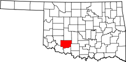
Location of Indiahoma, Oklahoma
Coordinates: 34°37′12″N98°45′07″W / 34.62000°N 98.75194°W / 34.62000; -98.75194
Country United States
State Oklahoma
County Comanche
Area
[1]
  Total0.28 sq mi (0.72 km2)
  Land0.28 sq mi (0.72 km2)
  Water0.00 sq mi (0.00 km2)
Elevation
[2]
1,345 ft (410 m)
Population
 (2020)
  Total275
  Density989.21/sq mi (381.46/km2)
Time zone UTC-6 (Central (CST))
  Summer (DST) UTC-5 (CDT)
ZIP code
73552
Area code 580
FIPS code 40-36850 [3]
GNIS feature ID2412791 [2]

Indiahoma is a town in Comanche County, Oklahoma, United States. It is located just south of US Route 62, about 24.4 driving miles west of Lawton. [4]

Contents

The population was 344 at the 2010 census. It is included as an exurb in the Lawton, Oklahoma, Metropolitan Statistical Area. It is also home to the Treasure Lake Job Corp.

Geography

According to the United States Census Bureau, the town has a total area of 0.3 square miles (0.78 km2), all land.

Demographics

Historical population
CensusPop.Note
1910 188
1920 1953.7%
1930 28847.7%
1940 33717.0%
1950 319−5.3%
1960 37818.5%
1970 43414.8%
1980 364−16.1%
1990 337−7.4%
2000 37411.0%
2010 344−8.0%
2020 275−20.1%
U.S. Decennial Census [5]

At the 2010 census, there were 344 people, 145 households, and 97 families in the town. The population density was 1,226.4 inhabitants per square mile (473.5/km2). There were 170 housing units at an average density of 607.1 per square mile (234.4/km2). The racial makeup of the town was 64.0% White, 27.9% Native American, 0.3% Asian, 1.5% from other races, and 6.4% from two or more races. Hispanic or Latino of any race were 11.9% of the population.

Of the 145 households 22.8% had children under the age of 18 living with them, 42.1% were married couples living together, 16.6% had a female householder with no husband present, and 33.1% were non-families. 27.6% of households were one person and 13.1% were one person aged 65 or older. The average household size was 2.37 and the average family size was 2.82.

The age distribution was 20.3% under the age of 18, 8.7% from 18 to 24, 21.8% from 25 to 44, 35.8% from 45 to 64, and 13.4% 65 or older. The median age was 44.4 years. For every 100 females, there were 98.8 males. For every 100 females age 18 and over, there were 87.7 males.

According to the 2000 census, the median household income was $21,071, and the median family income was $28,977. Males had a median income of $27,250 versus $19,063 for females. The per capita income for the town was $10,153. About 22.9% of families and 29.6% of the population were below the poverty line, including 33.6% of those under age 18 and 25.5% of those age 65 or over.

Related Research Articles

Stoneham is a town in Oxford County, Maine, United States. The population was 261 at the 2020 census.

<span class="mw-page-title-main">Lawton, North Dakota</span> City in North Dakota, United States

Lawton is a city in Ramsey County, North Dakota, United States. The population was 15 at the 2020 census. Lawton was founded in 1902.

<span class="mw-page-title-main">Elgin, Oklahoma</span> City in Oklahoma, United States

Elgin is a city in northeastern Comanche County, Oklahoma, United States. The population was 2,156 at the 2010 census, a 78 percent increase from 1,210 at the 2000 census. It is included in the Lawton, Oklahoma Metropolitan Statistical Area. It is the site of Fort Sill National Cemetery.

<span class="mw-page-title-main">Faxon, Oklahoma</span> Town in Oklahoma, United States

Faxon is a town in Comanche County, Oklahoma, United States. It is located on Oklahoma State Highway 36 about 18.3 driving miles southwest of Lawton. The population was 136 at the 2010 census. It is included in the Lawton, Oklahoma Metropolitan Statistical Area.

<span class="mw-page-title-main">Fletcher, Oklahoma</span> Town in Oklahoma, United States

Fletcher is a town in Comanche County, Oklahoma, United States. The population was 1,177 at the 2010 census. It is included in the Lawton, Oklahoma Metropolitan Statistical Area.

<span class="mw-page-title-main">Sterling, Oklahoma</span> Town in Oklahoma, United States

Sterling is a town in Comanche County, Oklahoma, United States. The population was 793 at the 2010 census. It is part of the Lawton Metropolitan Statistical Area.

<span class="mw-page-title-main">Depew, Oklahoma</span> Town in Oklahoma, United States

Depew is a town in Creek County, Oklahoma, United States. It is 41 miles southwest of Tulsa. The population was 411 at the 2020 census. The town was named in honor of New York Senator Chauncey Depew.

<span class="mw-page-title-main">Camargo, Oklahoma</span> City in Oklahoma, United States

Camargo is a town in Dewey County, Oklahoma, United States. The population was 178 at the 2010 census, an increase of 54.8 percent from the figure of 115 in 2000.

<span class="mw-page-title-main">Ringling, Oklahoma</span> Town in Oklahoma, United States

Ringling is a town in Jefferson County, Oklahoma, United States. The population was 1,037 at the 2010 census, a decline of 8.6 percent from the figure of 1,135 in 2000. It was named for John Ringling, the founder of the Ringling Brothers Circus.

<span class="mw-page-title-main">Gotebo, Oklahoma</span> Town in Oklahoma, United States

Gotebo is a town in Kiowa County, Oklahoma, United States. The population was 226 at the 2010 census, a decline of 16.9 percent from 272 in 2000.

<span class="mw-page-title-main">Carney, Oklahoma</span> Town in Oklahoma, United States

Carney is a town in Lincoln County, Oklahoma, United States. As of the 2020 census, the population of the town was 545.

<span class="mw-page-title-main">Davenport, Oklahoma</span> Town in Oklahoma, United States

Davenport is a town in Lincoln County, Oklahoma, United States. The population was 814 at the 2010 census.

<span class="mw-page-title-main">Millerton, Oklahoma</span> Town in Oklahoma, United States

Millerton is a town in McCurtain County, Oklahoma, United States. The population was 359 at the 2000 census. The oldest church building in Oklahoma, Wheelock Church, is located near Millerton.

<span class="mw-page-title-main">Lake Aluma, Oklahoma</span> Town in Oklahoma, United States

Lake Aluma is a town in Oklahoma County, Oklahoma, United States, and a part of the Oklahoma City Metropolitan Area. The population was 88 at the 2010 census.

<span class="mw-page-title-main">Hoffman, Oklahoma</span> Town in Oklahoma, United States

Hoffman is a town in Okmulgee County, Oklahoma, United States. The population was 81 at the 2020 census.

<span class="mw-page-title-main">Tribbey, Oklahoma</span> Town in Oklahoma, United States

Tribbey is a town in Pottawatomie County, Oklahoma, United States.The community was named for Alpheus M. Tribbey, landowner. The population was 391 at the 2010 census, a 43.2 percent gain from the figure of 273 in 2000.

<span class="mw-page-title-main">Foyil, Oklahoma</span> Town in Oklahoma, United States

Foyil is a town in Rogers County, Oklahoma, United States. It was named for Alfred Foyil, a local landowner and the first postmaster of the town. The population was 344 at the 2010 census, a 47.0 percent increase over the figure of 234 recorded in 2000.

<span class="mw-page-title-main">Manitou, Oklahoma</span> Town in Oklahoma, United States

Manitou is a town in Tillman County, Oklahoma, United States. The population was 181 at the 2010 census. It includes the former town of Siboney, absorbed on January 28, 1908.

<span class="mw-page-title-main">Rush Township, Susquehanna County, Pennsylvania</span> Township in Pennsylvania, United States

Rush Township is a township in Susquehanna County, Pennsylvania, United States. The population was 1,134 at the 2020 census. The village of Lawton is in the township.

<span class="mw-page-title-main">Chattanooga, Oklahoma</span> Town in Oklahoma, United States

Chattanooga is a town in Comanche and Tillman counties in the U.S. state of Oklahoma. It is located on Oklahoma State Highway 36 about 23.7 driving miles southwest of Lawton. The population was 461 at the 2010 census. The Comanche County portion of Chattanooga is included in the Lawton, Oklahoma Metropolitan Statistical Area.

References

  1. "ArcGIS REST Services Directory". United States Census Bureau. Retrieved September 20, 2022.
  2. 1 2 U.S. Geological Survey Geographic Names Information System: Indiahoma, Oklahoma
  3. "U.S. Census website". United States Census Bureau . Retrieved January 31, 2008.
  4. "Lawton, Oklahoma to Indiahoma, Oklahoma". Google Maps. Retrieved December 9, 2020.
  5. "Census of Population and Housing". Census.gov. Retrieved June 4, 2015.