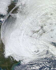
Hurricane Isabel was the strongest Atlantic hurricane since Mitch,and the deadliest,costliest,and most intense hurricane in the 2003 Atlantic hurricane season. Hurricane Isabel was also the strongest hurricane in the open waters of the Atlantic,both by wind speed and central pressure,before being surpassed by hurricanes Irma and Dorian in 2017 and 2019,respectively. The ninth named storm,fifth hurricane,and second major hurricane of the season,Isabel formed near the Cape Verde Islands from a tropical wave on September 6,in the tropical Atlantic Ocean. It moved northwestward,and within an environment of light wind shear and warm waters,it steadily strengthened to reach peak winds of 165 mph (266 km/h) on September 11. After fluctuating in intensity for four days,during which it displayed annular characteristics,Isabel gradually weakened and made landfall on the Outer Banks of North Carolina,with winds of 105 mph (169 km/h) on September 18. Isabel quickly weakened over land and became extratropical over western Pennsylvania on the next day. On September 20,the extratropical remnants of Isabel were absorbed into another system over Eastern Canada.

Hurricane Gloria was a powerful hurricane that caused significant damage along the east coast of the United States and in Atlantic Canada during the 1985 Atlantic hurricane season. It was the first significant tropical cyclone to strike the northeastern United States since Hurricane Agnes in 1972 and the first major storm to affect New York City and Long Island directly since Hurricane Donna in 1960. Gloria was a Cape Verde hurricane originating from a tropical wave on September 16 in the eastern Atlantic Ocean. After remaining a weak tropical cyclone for several days,Gloria intensified into a hurricane on September 22 north of the Lesser Antilles. During that time,the storm had moved generally westward,although it turned to the northwest due to a weakening of the ridge. Gloria quickly intensified on September 24,and the next day reached peak winds of 145 mph (233 km/h). The hurricane weakened before striking the Outer Banks of North Carolina on September 27. Later that day,Gloria made two subsequent landfalls on Long Island and across the coastline of western Connecticut,before becoming extratropical on September 28 over New England. The remnants moved through Atlantic Canada and went on to impact Western Europe,eventually dissipating on October 4.
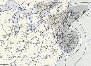
Hurricane Carol was among the worst tropical cyclones on record to affect the states of Connecticut and Rhode Island in the United States. It developed from a tropical wave near the Bahamas on August 25,1954,and slowly strengthened as it moved northwestward. On August 27,Carol intensified to reach winds of 105 mph (169 km/h),but weakened as its motion turned to a northwest drift. A strong trough of low pressure turned the hurricane northeastward,and Carol later intensified into a major hurricane. While paralleling the Mid-Atlantic and Southeastern United States,the storm produced strong winds and rough seas that caused minor coastal flooding and slight damage to houses in North Carolina,Virginia,Washington,D.C.,Delaware,and New Jersey. The well-organized hurricane accelerated north-northeastward and made landfall on eastern Long Island,New York,and then over eastern Connecticut on August 31 with sustained winds estimated at 110-mph and a barometric pressure near 956 mb. Carol later transitioned into an extratropical cyclone over New Hampshire,on August 31,1954.

Hurricane Belle was a strong tropical cyclone that caused moderate damage across the East Coast of the United States in August 1976. In late July,a tropical wave emerged off the west coast of Africa. Traversing the Atlantic Ocean for more than a week,the system eventually consolidated into a tropical depression near the Bahamas on August 6. Remaining nearly stationary for a day,the depression strengthened into a tropical storm on August 7 and a hurricane later that day as it acquired a northwest motion. Formation of an eye accompanied quick intensification and Belle reached its peak the following day with winds of 120 mph (190 km/h). The hurricane subsequently turned north and accelerated,skirting the Outer Banks of North Carolina. Early on August 10,Belle made landfall on Long Island,New York,as a minimal hurricane crossing Long Island Sound and hitting the central coast of Connecticut as a strong tropical storm. Thereafter,Belle transitioned into an extratropical cyclone over New England before moving over Atlantic Canada. The system turned east while over the North Atlantic and ultimately dissipated on August 15 to the south of Iceland.

Tropical Storm Tammy was a short-lived tropical cyclone that affected the East Coast of the United States in October 2005. The 19th named storm of the 2005 Atlantic hurricane season,Tammy formed on October 5 off the east coast of Florida from the interaction of a tropical wave and a trough. After strengthening to a peak intensity of 50 mph (85 km),the storm made landfall in northeastern Florida. Tammy moved into the U.S. state of Georgia,degenerating into a remnant low pressure area,which was absorbed by an extratropical cyclone over the eastern Gulf of Mexico. Tammy and its remnants contributed to ten fatalities.

The 1991 Perfect Storm,also known as The No-Name Storm and the Halloween Gale/Storm,was a damaging and deadly nor'easter in October 1991. Initially an extratropical cyclone,the storm absorbed Hurricane Grace to its south and evolved into a small unnamed hurricane later in its life. Damage from the storm totaled over $200 million and thirteen people were killed in total,six of which were an outcome of the sinking of Andrea Gail,which inspired the book and later movie,The Perfect Storm. The nor'easter received the name,playing off the common expression,after a conversation between Boston National Weather Service forecaster Robert Case and author Sebastian Junger.

The Christmas 1994 nor'easter was an intense cyclone along the East Coast of the United States and Atlantic Canada. It developed from an area of low pressure in the southeast Gulf of Mexico near the Florida Keys,and moved across the state of Florida. As it entered the warm waters of the Gulf Stream in the Atlantic Ocean,it began to rapidly intensify,exhibiting traits of a tropical system,including the formation of an eye. It attained a pressure of 970 millibars on December 23 and 24,and after moving northward,it came ashore near New York City on Christmas Eve. Because of the uncertain nature of the storm,the National Hurricane Center (NHC) did not classify it as a tropical cyclone.
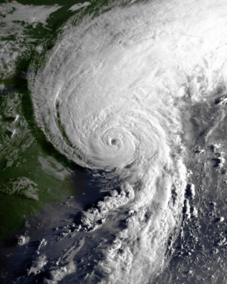
Hurricane Bob was one of the costliest hurricanes in New England history. The second named storm and first hurricane of the 1991 Atlantic hurricane season,Bob developed from an area of low pressure near The Bahamas on August 16. The depression steadily intensified,and became Tropical Storm Bob late on August 16. Bob curved north-northwestward as a tropical storm,but re-curved to the north-northeast after becoming a hurricane on August 17. As such,it brushed the Outer Banks of North Carolina on August 18 and August 19,and subsequently intensified into a major hurricane. After peaking in intensity with maximum sustained winds of 115 mph (185 km/h),Bob weakened slightly as it approached the coast of New England.
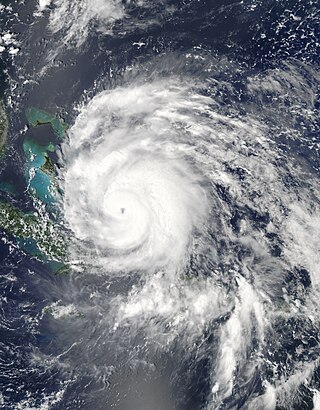
Hurricane Irene was a large and destructive tropical cyclone which affected much of the Caribbean and East Coast of the United States during late August 2011. The ninth named storm,first hurricane,and first major hurricane of the 2011 Atlantic hurricane season,Irene originated from a well-defined Atlantic tropical wave that began showing signs of organization east of the Lesser Antilles. Due to development of atmospheric convection and a closed center of circulation,the system was designated as Tropical Storm Irene on August 20,2011. After intensifying,Irene made landfall in St. Croix as a strong tropical storm later that day. Early on August 21,the storm made a second landfall in Puerto Rico. While crossing the island,Irene strengthened into a Category 1 hurricane. The storm paralleled offshore of Hispaniola,continuing to slowly intensify in the process. Shortly before making four landfalls in the Bahamas,Irene peaked as a 120 mph (190 km/h) Category 3 hurricane.

The 2011 Halloween nor'easter,sometimes referred to as "Snowtober," "Shocktober," "Storm Alfred," and "Oktoberblast," was a large low pressure area that produced unusually early snowfall across the northeastern United States and the Canadian Maritimes. It formed early on October 29 along a cold front to the southeast of the Carolinas. As it moved up the East Coast,its associated snowfall broke records in at least 20 cities for total accumulations,resulting in a rare "white Halloween" two days later.
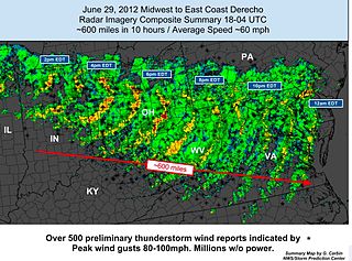
The June 2012 Mid-Atlantic and Midwest derecho was one of the deadliest and most destructive fast-moving severe thunderstorm complexes in North American history. The progressive derecho tracked across a large section of the Midwestern United States and across the central Appalachians into the mid-Atlantic states on the afternoon and evening of June 29,2012,and into the early morning of June 30,2012. It resulted in a total of 22 deaths,millions of power outages across the entire affected region,and a damage total of US$2.9 billion which exceeded that of all other derecho events aside from the August 2020 Midwest derecho. The storm prompted the issuance of four separate severe thunderstorm watches by the Storm Prediction Center. A second storm in the late afternoon caused another watch to be issued across Iowa and Illinois.

Hurricane Sandy was an extremely large and devastating tropical cyclone which ravaged the Caribbean and the coastal Mid-Atlantic region of the United States in late October 2012. It was the largest Atlantic hurricane on record as measured by diameter,with tropical-storm-force winds spanning 1,150 miles (1,850 km). The storm inflicted nearly $70 billion USD in damage,and killed 254 people in eight countries,from the Caribbean to Canada. The eighteenth named storm,tenth hurricane,and second major hurricane of the 2012 Atlantic hurricane season,Sandy was a Category 3 storm at its peak intensity when it made landfall in Cuba,though most of the damage it caused was after it became a Category 1-equivalent extratropical cyclone off the coast of the Northeastern United States.

Hurricane Sandy was the costliest natural disaster in the history of New Jersey,with economic losses to businesses of up to $30 billion. The most intense storm of the 2012 Atlantic hurricane season,Sandy formed in the Caribbean Sea on October 22. For days ahead of its eventual landfall,the hurricane was expected to turn toward New Jersey,as anticipated by tropical cyclone forecast models and the National Hurricane Center (NHC). On October 29,Sandy lost its characteristics of a tropical cyclone and transitioned into an extratropical cyclone while approaching the New Jersey coast. About two and a half hours later,the former hurricane moved ashore New Jersey near Brigantine in Atlantic County,just north of Atlantic City,producing wind gusts as strong as 91 mph (146 km/h).

New York was severely affected by Hurricane Sandy on October 29–30,2012,particularly New York City,its suburbs,and Long Island. Sandy's impacts included the flooding of the New York City Subway system,of many suburban communities,and of all road tunnels entering Manhattan except the Lincoln Tunnel. The New York Stock Exchange closed for two consecutive days. Numerous homes and businesses were destroyed by fire,including over 100 homes in Breezy Point,Queens. Large parts of the city and surrounding areas lost electricity for several days. Several thousand people in midtown Manhattan were evacuated for six days due to a crane collapse at Extell's One57. Bellevue Hospital Center and a few other large hospitals were closed and evacuated. Flooding at 140 West Street and another exchange disrupted voice and data communication in lower Manhattan.

The effects of Hurricane Sandy in Maryland and Washington,D.C., included tropical storm force sustained winds with isolated gusts to hurricane force,plus significant mountain snow and coastal flooding.

The February 2013 North American blizzard,also known as Winter Storm Nemo and the Blizzard of 2013,was a powerful blizzard that developed from the combination of two areas of low pressure,primarily affecting the Northeastern United States and parts of Canada,causing heavy snowfall and hurricane-force winds. The storm crossed the Atlantic Ocean,affecting Ireland and the United Kingdom. The nor'easter's effects in the United States received a Category 3 rank on the Northeast Snowfall Impact Scale,classifying it as a "Major" Winter Storm.

Hurricane Arthur was the earliest known hurricane to make landfall in the U.S. state of North Carolina during the calendar year. It was also the first hurricane to make landfall in the United States since Hurricane Isaac in 2012. The first named storm of the 2014 Atlantic hurricane season,Arthur developed from an initially non-tropical area of low-pressure over the Southeastern United States that emerged into the western Atlantic Ocean on June 28. After sufficiently organizing,developing a well-defined circulation and deep convection amid a favorable environment,it was classified as a tropical depression on July 1. The system continued to strengthen and was declared a tropical storm later that day. Drifting northward,the storm reached hurricane status early on July 3 and curved toward the north-northeast. Further structural organization resulted in additional intensification,and by 01:00 UTC on July 4,the system attained its peak winds of 100 mph (160 km/h) as a Category 2 hurricane on the Saffir–Simpson hurricane wind scale. Arthur made landfall at 03:15 UTC over North Carolina's Shackleford Banks,positioned between Cape Lookout and Beaufort,and intensified slightly further,with a minimum atmospheric pressure of 973 mbar. The storm then trekked swiftly northeast,weakening as it passed by Cape Cod and Nantucket,before transitioning into an extratropical cyclone and coming ashore at Weymouth,Nova Scotia,on July 5. The remnants continued generally northeastward through Atlantic Canada before ultimately dissipating on July 9 over the Labrador Sea.
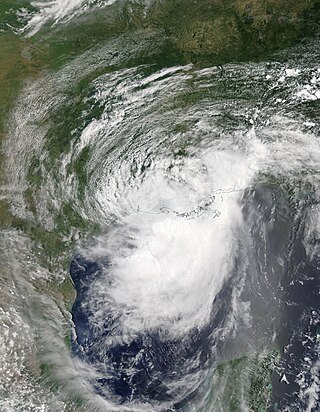
Hurricane Barry was an asymmetrical tropical cyclone that was the wettest on record in Arkansas and the fourth-wettest in Louisiana. The second tropical or subtropical storm and first hurricane of the 2019 Atlantic hurricane season,Barry originated as a mesoscale convective vortex over southwestern Kansas on July 2. The system eventually emerged into the Gulf of Mexico from the Florida Panhandle on July 10,whereupon the National Hurricane Center (NHC) designated it as a potential tropical cyclone. Early on July 11,the system developed into a tropical depression,and strengthened into a tropical storm later that day. Dry air and wind shear caused most of the convection,or thunderstorms,to be displaced south of the center. Nevertheless,Barry gradually intensified. On July 13,Barry attained its peak intensity as Category 1 hurricane with 1-minute sustained winds of 75 mph (120 km/h) and a minimum central pressure of 993 millibars (29.3 inHg). At 15:00 UTC,Barry made its first landfall at Marsh Island,and another landfall in Intracoastal City,Louisiana,both times as a Category 1 hurricane. Barry quickly weakened after landfall,falling to tropical depression status on July 15. The storm finally degenerated into a remnant low over northern Arkansas on the same day,subsequently opening up into a trough on July 16. The storm's remnants persisted for another few days,while continuing its eastward motion,before being absorbed into another frontal storm to the south of Nova Scotia on July 19.
