Elizabethtown, California

Last updated
Elizabethtown
Former settlement
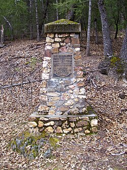
ElizabethTownMarker2.jpg
California Historical Landmark marker at the site of the former town
Coordinates: 39°57′50″N120°57′25″W / 39.963839°N 120.957081°W / 39.963839; -120.957081 Coordinates: 39°57′50″N120°57′25″W / 39.963839°N 120.957081°W / 39.963839; -120.957081
Country United States
State California
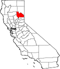
County Plumas County
Reference no.231 [1]

Elizabethtown, California was a California Gold Rush town that began in 1852 in Plumas County, California. It was named after a woman in the miners camp called Elizabeth Stark Blakesley. [2]

It is said that the value of gold taken from the Elizabethtown area ran into the millions of dollars. It was started from other gold mining camps all around American Valley (where Quincy, CA is now located). In 1852, a 10 to 15 family wagon train came up Beckwourth Pass (which was created by James Beckwourth, the first pioneer to this area). They brought a large supply of horses, oxen, cows, and other needed supplies and were the first settlers of American Valley. When they got there, they found a population of hundreds of Maidu Indians, which were peaceful and friendly. [2]

In 1852 Alexander and Frank Tate discovered gold in what is known as Tate ravine. After that, Lewis Stark, Peter Day, and George Ferrier one morning went up Elizabeth ravine and by noon they panned out an ounce of gold. After dinner they found several ounces using a rocker. After digging a small ditch, they discovered one 28 ounce gold piece. After that many miners came to search for gold which developed into a village. Later on Elizabethtown was also known as Betysburg after a rivalry started with Quincy. The winter of 1852 and 1853 were very harsh with low provisions. So the spring of 1853 the Stark family went to Sacramento Valley and hauled up many cattle for beef for the starving families. [3]

In 1854 a Masonic Lodge was built there. Also in 1854 Elizabethtown got postal service with Lewis Stark as Postmaster. W.A. Blakesley was the Deputy and used his house as the office. In January 1855 the postal service was moved to Quincy. The rich mining claims of 1853 and 1854 were: The Wahoo, by Joseph Kelley & Co.; Fowler, by Fowler & Co.; Varner, by Varner & Co.; Plumas, by L.F. Cate & Co.; O'Neill, by Captain O'Neill; Gloyd, by D.J. Gloyd; and Betsy Guilch, by Stark & Co. [4]

The Population of Elizabethtown got up around 2000 and 2500 people between 1853 and 1856. The first year over 30 county licenses were issued for business in the area. The Main Street extended across the entire town. There were many stores, two-story buildings, saloons, gambling houses, shops, gilded palaces, lodging houses, and eating houses. They also had a lodge for the Sons Of Temperance (see Temperance movement) which had over 200 members. [2] [5]

In 1857 and 1858 there was some demoralization within the town with the Comstock mines in Virginia City, Nevada (see Comstock Lode). Many residents ended up living in Indian and Honey Lake valleys. Many buildings were moved to Quincy and rebuilt there and slowly the town dissolved into history. [2]

After the "New Year's Flood" in January, 1997, a local resident discovered the cobblestone corner of a foundation had been exposed by the high water flow through the creek bed. The former excavations of the brick foundation has been covered over and no longer are visible. [6]

There is a stone and metal monument to the town by the Native Sons and Daughters of Quincy on September 9, 1927. [2]

Related Research Articles

Plumas County, California County in California, United States

Plumas County is a county in the Sierra Nevada of California, United States. As of the 2010 census, the population was 20,007. The county seat is Quincy, and the only incorporated city is Portola. The largest community in the county is East Quincy. The county was named for the Spanish Río de las Plumas, which flows through the county.

Sierra County, California County in California, United States

Sierra County is a county located in the U.S. state of California. As of the 2020 census, the population was 3,236, making it California's second-least populous county. The county seat is Downieville, and the only incorporated city is Loyalton. The county is in the Sierra Nevada, northeast of Sacramento on the border with Nevada.

Quincy, California census-designated place in California, United States

Quincy is a census-designated place and the county seat of Plumas County, California. The population was 1,728 during the 2010 census, down from 1,879 during the 2000 United States Census.

Downieville, California census-designated place in California, United States

Downieville is a census-designated place in and the county seat of Sierra County, California, United States. Downieville is on the North Fork of the Yuba River, at an elevation of 2,966 feet (904 m). The 2010 United States census reported Downieville's population was 282.

Shasta Cascade Mountainous region of California

The Shasta Cascade region of California is located in the northeastern and north-central sections of the state bordering Oregon and Nevada, including far northern parts of the Central Valley and the Sierra Nevada mountain range.

Fredonyer Pass

Fredonyer Pass, elevation 5,751 feet (1,753 m), is a high mountain pass in Lassen County, California, southwest of Susanville and southeast of Mount Lassen. It lies on the Great Basin Divide between the Feather River to the west and the Susan River and Honey Lake to the east.

James Beckwourth

James Pierson Beckwourth, was an American mountain man, fur trader, and explorer. Beckwourth was known as "Bloody Arm" because of his skill as a fighter. He was mixed-race and born into slavery in Virginia. He was freed by his white father and apprenticed to a blacksmith so that he could learn a trade.

Lassen National Forest

Lassen National Forest is a United States national forest of 1,700 square miles (4,300 km2) in northeastern California. It is named after pioneer Peter Lassen, who mined, ranched and promoted the area to emigrant parties in the 1850s.

Plumas National Forest National Forest in northern California, United States

Plumas National Forest is a 1,146,000-acre (4,638 km2) United States National Forest located at the northern terminus of the Sierra Nevada, in northern California. The Forest was named after its primary watershed, the Rio de las Plumas, or Feather River.

California State Route 70 Highway in California

State Route 70 is a state highway in the U.S. state of California, connecting SR 99 north of Sacramento with U.S. Route 395 near Beckwourth Pass via the Feather River Canyon. Through the Feather River Canyon, from SR 149 to US 395, SR 70 is the Feather River Scenic Byway, a Forest Service Byway that parallels the ex-Western Pacific Railroad's Feather River Route.

Beckwourth Pass Mountain pass in the Sierra Nevada mountain range

Beckwourth Pass is the lowest mountain pass in the Sierra Nevada mountain range at an elevation of 5,221 feet (1,591 m).

Area code 530 Area code for parts of northern California

Area code 530 is a California telephone area code in northeastern and Northern California.

Forest, California Unincorporated community in California, United States

Forest, also known as Forest City, is a small unincorporated community town site in Sierra County, California, United States, in the Sierra Nevada.

There are 28 routes assigned to the "A" zone of the California Route Marker Program, which designates county routes in California. The "A" zone includes county highways in Lassen, Plumas, Shasta, Siskiyou, and Tehama counties.

Schroeder Mountain

Schroeder Mountain is a mountain in the California's Sierra Nevada, on the Tahoe National Forest. It is located 0.8 miles (1 km) east of California State Route 49 in Sierra County. Its elevation is 6,942 feet (2,116 m).

American Ranch Place in California, United States

The American Ranch was a 160-acre farm and lodging house located in the American Valley, now Quincy, California.

The Sagebrush War was an armed conflict between the California county of Plumas and the now-defunct Nevada County of Roop over the jurisdiction of Lake Honey Valley and Susanville, California.

James Humphrey Haun was a gold miner, farmer and diarist. He left five volumes of diaries chronicling the California Gold Rush and its aftermath, from 1853-1959. His records are stored at the Plumas County Museum in Quincy, California

The Superior Court of California, County of Sierra, also known as the Sierra County Superior Court or Sierra Superior Court, is the branch of the California superior court with jurisdiction over Sierra County.

Dixie Fire 2021 North American wildfire

The Dixie Fire is an active wildfire in Butte, Plumas, Lassen, Shasta, and Tehama Counties, California. It is named after the road where it started. The fire began in the Feather River Canyon near Cresta Dam on July 13, 2021, and had burned 963,276 acres (389,824 ha) by September 27, with 94 percent containment. Since July, the fire has burned primarily north through the Lake Almanor area into Lassen Volcanic National Park and east through Indian Valley towards the Diamond Mountains. The fire has damaged or destroyed several small towns, including Greenville on August 4 and Canyondam on August 5.

References

  1. "Elizabethtown". Office of Historic Preservation, California State Parks. Retrieved 2012-10-11.
  2. 1 2 3 4 5 Elizabethtown Pioneer Trails 1927 Monument Speech - 79.29 (29th submission submitted to county museum in 1979) - Plumas County Museum
  3. Pages 276 and 277 of "Reproduction of Fariss and Smith's History of Plumas, Lassen & Sierra Counties, California, 1882; and biographical sketches of their prominent men and pioneers. With introd. by W. H. Hutchinson." Howell-North Books Berkeley, CA 1971 ISBN   0-8310-7083-8 Library of Congress Catalog Card Number 74-163648
  4. Page 277 of "Reproduction of Fariss and Smith's History of Plumas, Lassen & Sierra Counties, California, 1882; and biographical sketches of their prominent men and pioneers. With introd. by W. H. Hutchinson." Howell-North Books Berkeley, CA 1971 ISBN   0-8310-7083-8 Library of Congress Catalog Card Number 74-163648
  5. "Haun Collection Archive". Archived from the original on 2017-05-20. Retrieved 2017-05-20.
  6. Plumas County Museum http://www.plumasmuseum.org/