Fairhope Township, Pennsylvania

Last updated
Fairhope Township, Somerset County, Pennsylvania
Packsaddle Covered Bridge.jpg
Map of Somerset County, Pennsylvania highlighting Fairhope Township.PNG
Map of Somerset County, Pennsylvania Highlighting Fairhope Township
Map of Pennsylvania highlighting Somerset County.svg
Map of Somerset County, Pennsylvania
Country United States
State Pennsylvania
County Somerset
Area
[1]
  Total14.60 sq mi (37.81 km2)
  Land14.60 sq mi (37.81 km2)
  Water0.00 sq mi (0.00 km2)
Population
 (2020) [2]
  Total102 Decrease2.svg
  Estimate 
(2021) [2]
101
  Density8.84/sq mi (3.41/km2)
Time zone UTC-5 (Eastern (EST))
  Summer (DST) UTC-4 (EDT)
FIPS code 42-111-24680

Fairhope Township is a township in Somerset County, Pennsylvania, United States. The population was 102 at the 2020 census. [2] It is part of the Johnstown, Pennsylvania, Metropolitan Statistical Area.

Contents

History

The Packsaddle Bridge was added to the National Register of Historic Places in 1980. [3]

Geography

According to the United States Census Bureau, the township has a total area of 14.8 square miles (38 km2), all land. Fairhope Township is bordered by Southampton Township to the south, Northampton Township to the west, Allegheny Township to the north, and Bedford County to the east. Wills Creek flows into Fairhope Township from Northampton Township. The unincorporated community of Fairhope is located within Fairhope Township, as are the communities of Foley and Williams Station. All three sit along Wills Creek and CSX Transportation's Keystone Subdivision railroad. Shaffers Run flows into Wills Creek just northwest (upstream) of Fairhope, and Brush Creek joins Wills Creek slightly west (upstream) of that.

Recreation

A sizeable portion of the township is occupied by Pennsylvania State Game Lands Number 104. [4] [5]

Demographics

Historical population
CensusPop.Note
2010 134
2020 102−23.9%
2021 (est.)101 [2] −1.0%
U.S. Decennial Census [6]

At the 2000 census there were 137 people, 59 households, and 41 families living in the township. The population density was 9.3 people per square mile (3.6/km2). There were 112 housing units at an average density of 7.6/sq mi (2.9/km2). The racial makeup of the township was 100.00% White. [7] Of the 59 households 25.4% had children under the age of 18 living with them, 61.0% were married couples living together, and 30.5% were non-families. 28.8% of households were one person and 10.2% were one person aged 65 or older. The average household size was 2.32 and the average family size was 2.85.

The age distribution was 19.7% under the age of 18, 8.0% from 18 to 24, 25.5% from 25 to 44, 26.3% from 45 to 64, and 20.4% 65 or older. The median age was 42 years. For every 100 females there were 124.6 males. For every 100 females age 18 and over, there were 120.0 males.

The median household income was $28,958 and the median family income was $29,688. Males had a median income of $31,667 versus $14,250 for females. The per capita income for the township was $13,087. There were 7.7% of families and 11.4% of the population living below the poverty line, including 14.7% of under eighteens and 16.0% of those over 64.

Related Research Articles

<span class="mw-page-title-main">Bedford Township, Pennsylvania</span> Township in Pennsylvania, United States

Bedford Township is a township in Bedford County, Pennsylvania, United States. The population was 5,107 at the 2020 census.

<span class="mw-page-title-main">Cumberland Valley Township, Bedford County, Pennsylvania</span> Township in Pennsylvania, United States

Cumberland Valley Township is a township in Bedford County, Pennsylvania, United States. The population was 1,450 at the 2020 census.

<span class="mw-page-title-main">Harrison Township, Bedford County, Pennsylvania</span> Township in Pennsylvania, United States

Harrison Township is a township in Bedford County, Pennsylvania, United States. The population was 932 at the 2020 census.

<span class="mw-page-title-main">Hyndman, Pennsylvania</span> Borough in Pennsylvania, United States

Hyndman is a borough in Bedford County, Pennsylvania, United States. As of the 2020 census, the population was 863.

<span class="mw-page-title-main">Londonderry Township, Bedford County, Pennsylvania</span> Township in Pennsylvania, United States

Londonderry Township is a township in Bedford County, Pennsylvania, United States. It is named after County Londonderry, now in Northern Ireland. The population was 1,643 at the 2020 census.

<span class="mw-page-title-main">Monroe Township, Bedford County, Pennsylvania</span> Township in Pennsylvania, United States

Monroe Township is a township in Bedford County, Pennsylvania, United States. The population was 1,398 at the 2020 census.

<span class="mw-page-title-main">Portage Township, Cameron County, Pennsylvania</span> Township in Pennsylvania, United States

Portage Township is a township in Cameron County, Pennsylvania, United States. The population was 163 at the 2020 census, down from 171 in 2010.

<span class="mw-page-title-main">Brush Creek Township, Pennsylvania</span> Township in Pennsylvania, United States

Brush Creek Township is a township in Fulton County, Pennsylvania, United States. The population was 736 at the 2020 census.

<span class="mw-page-title-main">Knox Township, Jefferson County, Pennsylvania</span> Township in Pennsylvania, United States

Knox Township is a township in Jefferson County, Pennsylvania, in the United States. As of the 2020 census, the township population was 1,008. It was named for John C. Knox, then President Judge of the judicial district.

<span class="mw-page-title-main">Warsaw Township, Pennsylvania</span> Township in Pennsylvania, United States

Warsaw Township is a township in Jefferson County, Pennsylvania, United States. As of the 2020 census, the township population was 1,367.

<span class="mw-page-title-main">Washington Township, Jefferson County, Pennsylvania</span> Township in Pennsylvania, United States

Washington Township is a township in Jefferson County, Pennsylvania, United States. The population was 1,892 at the 2020 census. It was named for President George Washington.

<span class="mw-page-title-main">Winslow Township, Pennsylvania</span> Township in Pennsylvania, United States

Winslow Township is a township in Jefferson County, Pennsylvania, United States. The population was 2,543 at the 2020 census. It was named for Associate Judge James Winslow.

<span class="mw-page-title-main">Forks Township, Northampton County, Pennsylvania</span> Place in Pennsylvania, United States

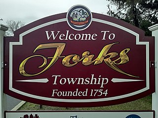
Forks Township is a township in Northampton County, Pennsylvania. The population of Forks Township was 14,721 as of the 2010 census. It is part of the Lehigh Valley metropolitan area, which had a population of 861,899 and was the 68th-most populous metropolitan area in the U.S. as of the 2020 census. The township is home to the global headquarters of Crayola, founded in 1885, a global arts supply company and the world's leading manufacturer of crayons.

<span class="mw-page-title-main">Moore Township, Pennsylvania</span> Place in Pennsylvania, United States

Moore Township is a township in Northampton County, Pennsylvania. The population of Moore Township was 9,198 at the 2010 census. The township is located in the Lehigh Valley, which had a population of 861,899 and was the 68th-most populous metropolitan area in the U.S. as of the 2020 census.

<span class="mw-page-title-main">Washington Township, Northampton County, Pennsylvania</span> Township in Pennsylvania, United States

Washington Township is a township in Northampton County, Pennsylvania. The population of Washington Township was 5,122 at the 2010 census. Washington Township is part of the Lehigh Valley metropolitan area, which had a population of 861,899 and was the 68th-most populous metropolitan area in the U.S. as of the 2020 census.

<span class="mw-page-title-main">Allegheny Township, Somerset County, Pennsylvania</span> Township in Pennsylvania, United States

Allegheny Township is a township in Somerset County, Pennsylvania, United States. The population was 615 at the 2020 census. It is part of the Johnstown, Pennsylvania, Metropolitan Statistical Area.

<span class="mw-page-title-main">Brothersvalley Township, Pennsylvania</span> Township in Pennsylvania, United States

Brothersvalley Township is a township in Somerset County, Pennsylvania, United States. The population was 2,377 at the 2020 census. It is part of the Johnstown, Pennsylvania, Metropolitan Statistical Area.

<span class="mw-page-title-main">Larimer Township, Pennsylvania</span> Township in Pennsylvania, United States

Larimer Township is a township in Somerset County, Pennsylvania, United States. The population was 543 at the 2020 census. It is part of the Johnstown, Pennsylvania, Metropolitan Statistical Area. Larimer Township was named for General William Larimer, Jr., president of the Pittsburgh & Connellsville Railroad.

<span class="mw-page-title-main">Northampton Township, Somerset County, Pennsylvania</span> Township in Pennsylvania, United States

Northampton Township is a township in Somerset County, Pennsylvania, United States. The population was 303 at the 2020 census. It is part of the Johnstown, Pennsylvania, Metropolitan Statistical Area.

<span class="mw-page-title-main">Southampton Township, Somerset County, Pennsylvania</span> Township in Pennsylvania, United States

Southampton Township is a township in Somerset County, Pennsylvania, United States. The population was 604 at the 2020 census. It is part of the Johnstown, Pennsylvania, Metropolitan Statistical Area.
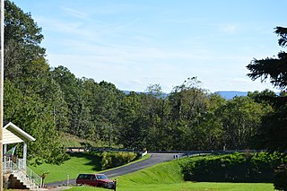
References

  1. "2016 U.S. Gazetteer Files". United States Census Bureau. Retrieved Aug 14, 2017.
  2. 1 2 3 4 Bureau, US Census. "City and Town Population Totals: 2020—2021". Census.gov. US Census Bureau. Retrieved July 24, 2022.
  3. "National Register Information System". National Register of Historic Places . National Park Service. July 9, 2010.
  4. https://viewer.nationalmap.gov/advanced-viewer/ Archived 2012-03-29 at the Wayback Machine The National Map, retrieved 20 October 2018
  5. Pennsylvania State Game Lands Number 104, retrieved 20 October 2018
  6. "Census of Population and Housing". Census.gov. Retrieved June 4, 2016.
  7. "U.S. Census website". United States Census Bureau . Retrieved 2008-01-31.

39°50′11″N78°47′02″W / 39.83639°N 78.78389°W / 39.83639; -78.78389