Milford Township, Somerset County, Pennsylvania

Last updated

Milford Township,
Somerset County,
Pennsylvania
Milford Township, Somerset County, Pennsylvania farm landscape.jpg
A farm in Milford Township
Map of Somerset County, Pennsylvania highlighting Milford Township.PNG
Map of Somerset County, Pennsylvania Highlighting Milford Township
Map of Pennsylvania highlighting Somerset County.svg
Map of Somerset County, Pennsylvania
Country United States
State Pennsylvania
County Somerset
Organized1780
Area
[1]
  Total29.75 sq mi (77.06 km2)
  Land29.75 sq mi (77.05 km2)
  Water0.01 sq mi (0.01 km2)
Population
 (2020) [2]
  Total1,488 Decrease2.svg
  Estimate 
(2021) [2]
1,483
  Density50.96/sq mi (19.68/km2)
Time zone UTC-5 (Eastern (EST))
  Summer (DST) UTC-4 (EDT)
FIPS code 42-111-49416

Milford Township is a township in Somerset County, Pennsylvania, United States. The population was 1,488 at the 2020 census. [2] It is part of the Johnstown, Pennsylvania, Metropolitan Statistical Area.

Contents

History

Milford Township was formed from part of Turkeyfoot Township about 1780, when both were still part of a larger Bedford County; Somerset County was not formed from the western portion of Bedford County until 17 April 1795. [3] Neither the exact time nor its original boundaries are known. The original Milford Township included those parts of Somerset and Jefferson townships that lie south of the old Glades road, or the pike, until 1796, and also Middlecreek Township which was separated in 1853 and Black Township which was separated in 1886, whence Milford Township took its current outlines. [3]

Geography

According to the United States Census Bureau, Milford Township has a total area of 29.2 square miles (75.8 km2), of which 29.2 square miles (75.8 km2) is land and 0.03% is water. The township surrounds the borough of New Centerville. Milford Township is bordered by Jefferson Township to the northwest, Somerset Township to the northeast, Black Township to the southeast, Upper Turkeyfoot Township to the southwest, and Middlecreek Township to the west.

Pennsylvania Route 281 passes through Milford Township, generally running northeast from New Lexington in Middlecreek Township, passing through New Centerville and bisecting Milford Township, and continuing through the southwestern part of Somerset Township on its way to the borough of Somerset. From New Lexington to New Centerville, Pennsylvania Route 281 & Pennsylvania Route 653 form a concurrency; in New Centerville, Pennsylvania Route 653 splits off and runs southeast to the borough of Rockwood. Rockwood sits at the confluence of Coxes Creek and the Casselman River, between Milford Township to the northwest and Black Township to the southeast. Black Township had been part of Milford Township until it was split off in 1886. [4]

Demographics

Historical population
CensusPop.Note
2010 1,553
2020 1,488−4.2%
2021 (est.)1,483 [2] −0.3%
U.S. Decennial Census [5]

At the 2000 census there were 1,561 people, 602 households, and 473 families living in the township. The population density was 53.4 inhabitants per square mile (20.6/km2). There were 658 housing units at an average density of 22.5/sq mi (8.7/km2). The racial makeup of the township was 99.81% White, 0.06% African American, 0.06% Asian, and 0.06% from two or more races. Hispanic or Latino of any race were 0.19%. [6]

Of the 602 households 30.2% had children under the age of 18 living with them, 69.6% were married couples living together, 5.1% had a female householder with no husband present, and 21.4% were non-families. 18.6% of households were one person and 8.8% were one person aged 65 or older. The average household size was 2.58 and the average family size was 2.93.

The age distribution was 22.4% under the age of 18, 6.3% from 18 to 24, 28.6% from 25 to 44, 26.8% from 45 to 64, and 15.8% 65 or older. The median age was 41 years. For every 100 females, there were 98.9 males. For every 100 females age 18 and over, there were 99.8 males.

The median household income was $34,458 and the median family income was $38,750. Males had a median income of $29,038 versus $21,000 for females. The per capita income for the township was $14,836. About 11.4% of families and 14.3% of the population were below the poverty line, including 17.5% of those under age 18 and 25.0% of those age 65 or over.

Related Research Articles

<span class="mw-page-title-main">Somerset County, Pennsylvania</span> County in Pennsylvania, United States

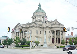
Somerset County is a county in the Commonwealth of Pennsylvania. As of the 2020 census, the population was 74,129. Its county seat is Somerset. The county was created from part of Bedford County on April 17, 1795, and named after the county of Somerset in England.

<span class="mw-page-title-main">Henry Clay Township, Fayette County, Pennsylvania</span> Township in Pennsylvania, United States

Henry Clay Township is a township in Fayette County, Pennsylvania, United States. The population was 1,765 at the 2020 census. The township was created June 9, 1824, from the eastern portion of Wharton Township. It is named for 19th-century American statesman Henry Clay. The northwestern corner of its territory was used to create Stewart Township on November 17, 1855. It is served by the Uniontown Area School District.

<span class="mw-page-title-main">Springfield Township, Fayette County, Pennsylvania</span> Township in Pennsylvania, United States

Springfield Township is a township in Fayette County, Pennsylvania, United States. The population was 2,730 at the 2020 census. The Connellsville Area School District serves the township.

<span class="mw-page-title-main">Addison Township, Somerset County, Pennsylvania</span> Township in Pennsylvania, United States

Addison Township is a township in Somerset County, Pennsylvania, United States. The population was 928 at the 2020 census. It is part of the Johnstown, Pennsylvania, Metropolitan Statistical Area. The township is named for Alexander Addison, the first president judge overseeing Somerset County.

<span class="mw-page-title-main">Black Township, Somerset County, Pennsylvania</span> Township in Pennsylvania, United States

Black Township is a township in Somerset County, Pennsylvania, United States. The population was 899 at the 2020 census. It is part of the Johnstown, Pennsylvania, Metropolitan Statistical Area. The township was named for Jeremiah Sullivan Black, a native of Somerset County who became Chief Justice of the Supreme Court of Pennsylvania, U.S. Attorney General, and U.S Secretary of State.

<span class="mw-page-title-main">Casselman, Pennsylvania</span> Borough in Pennsylvania, United States

Casselman is a borough in Somerset County, Pennsylvania, United States.

<span class="mw-page-title-main">Elk Lick Township, Somerset County, Pennsylvania</span> Township in Pennsylvania, United States

Elk Lick Township is a township in Somerset County, Pennsylvania, United States. The population was 2,257 at the 2020 census. Mount Davis, the highest point in Pennsylvania, is located within the township.

<span class="mw-page-title-main">Garrett, Pennsylvania</span> Borough in Pennsylvania, United States

Garrett is a borough in Somerset County, Pennsylvania, United States. It is part of the Johnstown, Pennsylvania, Metropolitan Statistical Area. The population was 416 at the 2020 census.

<span class="mw-page-title-main">Jefferson Township, Somerset County, Pennsylvania</span> Township in Pennsylvania, United States

Jefferson Township is a township in Somerset County, Pennsylvania, United States. The population was 1,428 at the 2020 census. It is part of the Johnstown, Pennsylvania, Metropolitan Statistical Area.

<span class="mw-page-title-main">Lower Turkeyfoot Township, Pennsylvania</span> Township in Pennsylvania, United States

Lower Turkeyfoot Township is a township in Somerset County, Pennsylvania, United States. The population was 543 at the 2020 census. It is part of the Johnstown, Pennsylvania, Metropolitan Statistical Area.

<span class="mw-page-title-main">Middlecreek Township, Somerset County, Pennsylvania</span> Township in Pennsylvania, United States

Middlecreek Township is a township in Somerset County, Pennsylvania, United States. The population was 831 at the 2020 census. It is part of the Johnstown, Pennsylvania, Metropolitan Statistical Area.

<span class="mw-page-title-main">New Centerville, Pennsylvania</span> Borough in Pennsylvania, United States

New Centerville is a borough in Somerset County, Pennsylvania, United States. The population was 127 at the 2020 census. It is part of the Johnstown, Pennsylvania, Metropolitan Statistical Area. It should not be confused with the unincorporated village of New Centerville in Tredyffrin Township.

<span class="mw-page-title-main">Quemahoning Township, Pennsylvania</span> Township in Pennsylvania, United States

Quemahoning Township is a township in Somerset County, Pennsylvania, United States. The population was 1,838 at the 2020 census. It is part of the Johnstown, Pennsylvania, Metropolitan Statistical Area.

<span class="mw-page-title-main">Rockwood, Pennsylvania</span> Borough in Pennsylvania, United States

Rockwood is a borough in Somerset County, Pennsylvania, United States. The population was 850 at the 2020 census. It is part of the Johnstown, Pennsylvania, Metropolitan Statistical Area, and located due north of Pennsylvania's highest peak, Mount Davis, which significantly constricts land travel routing south of the municipality.

<span class="mw-page-title-main">Somerset Township, Somerset County, Pennsylvania</span> Township in Pennsylvania, United States

Somerset Township is a township in Somerset County, Pennsylvania, United States. The population was 12,165 at the 2020 census. It is part of the Johnstown, Pennsylvania, Metropolitan Statistical Area and encompasses the census-designated place (CDP) of Friedens.

<span class="mw-page-title-main">Summit Township, Somerset County, Pennsylvania</span> Township in Pennsylvania, United States

Summit Township is a township in Somerset County, Pennsylvania, United States. The population was 2,141 at the 2020 census. It is part of the Johnstown, Pennsylvania, Metropolitan Statistical Area.

<span class="mw-page-title-main">Upper Turkeyfoot Township, Pennsylvania</span> Township in Pennsylvania, United States

Upper Turkeyfoot Township is a township in Somerset County, Pennsylvania, United States. The population was 1,063 at the 2020 census. It is part of the Johnstown, Pennsylvania, Metropolitan Statistical Area.

<span class="mw-page-title-main">Ursina, Pennsylvania</span> Borough in Pennsylvania, United States

Ursina is a borough in Somerset County, Pennsylvania, United States. It is part of the Johnstown, Pennsylvania, Metropolitan Statistical Area. The population was 244 at the 2020 census.

<span class="mw-page-title-main">Pennsylvania House of Representatives, District 69</span> American legislative district

The 69th Pennsylvania House of Representatives District is located in southern Pennsylvania and has been represented by Carl Walker Metzgar since 2009.

<span class="mw-page-title-main">Rockwood Area School District</span> School district in Pennsylvania

The Rockwood Area School District is a public school district located in Somerset County, Pennsylvania. It serves the boroughs of Rockwood, New Centerville, Casselman, and Seven Springs, plus the townships of Milford Township, Black Township, Upper Turkeyfoot Township, and Middlecreek Township in Somerset County, Pennsylvania. The district encompasses approximately 146 sq mi (380 km2). According to 2007 local census data, it serves a resident population of 5,680.

References

  1. "2016 U.S. Gazetteer Files". United States Census Bureau. Retrieved August 14, 2017.
  2. 1 2 3 4 Bureau, US Census. "City and Town Population Totals: 2020—2021". Census.gov. US Census Bureau. Retrieved July 24, 2022.
  3. 1 2 History of Bedford, Somerset and Fulton Counties, Pennsylvania. Chicago: Waterman, Watkins & Co. 1884. pp. 440, 556-566.
  4. "Black Township". PAGenWeb Project. Retrieved May 26, 2020.
  5. "Census of Population and Housing". Census.gov. Retrieved June 4, 2016.
  6. "U.S. Census website". United States Census Bureau . Retrieved January 31, 2008.

40°00′06″N79°10′29″W / 40.00167°N 79.17472°W / 40.00167; -79.17472