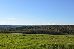
Callimont, Pennsylvania

Last updated
Callimont, Pennsylvania
Borough
Callimont Gameland Road.jpg
Gameland Road
Somerset County Pennsylvania Incorporated and Unincorporated areas Callimont Highlighted.svg
Location of Callimont in Somerset County, Pennsylvania.
Coordinates: 39°48′05″N78°56′56″W / 39.80139°N 78.94889°W / 39.80139; -78.94889 Coordinates: 39°48′05″N78°56′56″W / 39.80139°N 78.94889°W / 39.80139; -78.94889
Country United States
State Pennsylvania
County Somerset
Government
  TypeBorough Council
Area
[1]
  Total4.36 sq mi (11.28 km2)
  Land4.36 sq mi (11.28 km2)
  Water0.00 sq mi (0.00 km2)
Elevation
2,240 ft (680 m)
Population
 (2020) [2]
  Total56
  Density12.86/sq mi (4.96/km2)
Time zone UTC-5 (Eastern (EST))
  Summer (DST) UTC-4 (EDT)
Area code 814
FIPS code 42-10808

Callimont is a borough in Somerset County, Pennsylvania, United States. The population was 53 at the 2020 census. [3] It is part of the Johnstown, Pennsylvania, Metropolitan Statistical Area.

Contents

Geography

Callimont is at 39°48′05″N78°56′56″W / 39.80139°N 78.94889°W / 39.80139; -78.94889 (39.8015, -78.9488), [4] approximately 13.5 miles (22 km) north-northwest of Cumberland, Maryland. According to the United States Census Bureau, the borough has a total area of 4.5 square miles (12 km2), all land.

Demographics

Historical population
CensusPop.Note
1980 32
1990 5571.9%
2000 51−7.3%
2010 41−19.6%
2020 5329.3%
2021 (est.)52 [3] −1.9%
Sources: [5] [6] [7] [8] [2]

As of the census [6] of 2000, there were 51 people, 19 households, and 14 families living in the borough. The population density was 11.4 people per square mile (4.4/km2). There were 24 housing units at an average density of 5.4 per square mile (2.1/km2). The racial makeup of the borough was 100.00% White.

There were 19 households, out of which 26.3% had children under the age of 18 living with them, 57.9% were married couples living together, 21.1% had a female householder with no husband present, and 21.1% were non-families. 21.1% of all households were made up of individuals, and 5.3% had someone living alone who was 65 years of age or older. The average household size was 2.68 and the average family size was 2.87.

In the borough the population was spread out, with 21.6% under the age of 18, 13.7% from 18 to 24, 27.5% from 25 to 44, 29.4% from 45 to 64, and 7.8% who were 65 years of age or older. The median age was 35 years. For every 100 females there were 96.2 males. For every 100 females age 18 and over, there were 110.5 males.

The median income for a household in the borough was $49,750, and the median income for a family was $49,250. Males had a median income of $38,750 versus $30,000 for females. The per capita income for the borough was $19,813. There were no families and 3.8% of the population living below the poverty line, including no under eighteen and none of those over 64.

Related Research Articles

<span class="mw-page-title-main">Port Heiden, Alaska</span> City in Alaska, United States

Port Heiden is a city in Lake and Peninsula Borough, Alaska, United States. As of the 2020 census, the population of the city is 100, slightly down from 102 in 2010.

<span class="mw-page-title-main">Low Moor, Iowa</span> City in Iowa, United States

Low Moor is a city in Clinton County, Iowa, United States. The population was 250 at the time of the 2020 census.

<span class="mw-page-title-main">Midland, Maryland</span> Town in Maryland, United States

Midland is a town in Allegany County, Maryland, United States, along the Georges Creek Valley. It is part of the Cumberland, MD-WV Metropolitan Statistical Area. The population was 446 at the 2010 census. Midland was founded in 1850 as a coal-mining community, though today only some strip mining remains.

<span class="mw-page-title-main">Secretary, Maryland</span> Town in Maryland, United States

Secretary is a town in Dorchester County, Maryland, United States. The population was 535 at the 2010 census.

<span class="mw-page-title-main">Etna, Pennsylvania</span> Borough in Pennsylvania, United States

Etna is a borough of Allegheny County, Pennsylvania, United States, located across the Allegheny River from Pittsburgh. In 2019, Etna was recognized as the first ever Ecodistrict.

<span class="mw-page-title-main">Fairview, Butler County, Pennsylvania</span> Borough in Pennsylvania, United States

Fairview is a borough in Butler County, Pennsylvania, United States. The population was 198 at the 2010 census. It should not be confused with Fairview in Erie County, which carries the ZIP code 16415.

<span class="mw-page-title-main">Carrolltown, Pennsylvania</span> Borough in Pennsylvania, United States

Carrolltown is a borough in Cambria County, Pennsylvania, United States. The population was 853 at the 2010 census, down from 1,049 at the 2000 census. It is part of the Johnstown, Pennsylvania Metropolitan Statistical Area.

<span class="mw-page-title-main">Ferndale, Pennsylvania</span> Borough in Pennsylvania, United States

Ferndale is a borough in Cambria County, Pennsylvania, United States. It is part of the Johnstown, Pennsylvania Metropolitan Statistical Area. The population was 1,636 at the 2010 census, down from 1,834 at the 2000 census.

<span class="mw-page-title-main">Geistown, Pennsylvania</span> Borough in Pennsylvania, United States

Geistown is a borough in Cambria County, Pennsylvania, United States. It is part of the Johnstown, Pennsylvania Metropolitan Statistical Area. The population was 2,467 at the 2010 census.

<span class="mw-page-title-main">Hastings, Pennsylvania</span> Borough in Pennsylvania, United States

Hastings is a borough in Cambria County, Pennsylvania, United States. It is part of the Johnstown, Pennsylvania Metropolitan Statistical Area. The population was 1,278 at the 2010 census.

<span class="mw-page-title-main">Southmont, Pennsylvania</span> Borough in Pennsylvania, United States

Southmont is a borough in Cambria County, Pennsylvania, United States. It is part of the Johnstown, Pennsylvania Metropolitan Statistical Area. The population was 2,284 at the 2010 census. It was incorporated in 1919 out of Upper Yoder Township.

<span class="mw-page-title-main">Troutville, Pennsylvania</span> Borough in Pennsylvania, United States

Troutville is a borough in Clearfield County, Pennsylvania, United States. The population was 230 at the 2020 census.

<span class="mw-page-title-main">Markleysburg, Pennsylvania</span> Borough in Pennsylvania, United States

Markleysburg is a borough in Fayette County, Pennsylvania, United States. The population was 246 at the 2020 census. The borough is served by the Uniontown Area School District.

<span class="mw-page-title-main">Smithfield, Pennsylvania</span> Borough in Pennsylvania, United States

Smithfield is a borough in Fayette County, Pennsylvania, United States. The population was 830 at the 2020 census. It is served by the Albert Gallatin Area School District. The town's largest employer is a small wire producing plant run by Nelson Steel.

<span class="mw-page-title-main">Valley-Hi, Pennsylvania</span> Borough in Pennsylvania, United States

Valley-Hi is a borough in Fulton County, Pennsylvania, United States. The population was 7 at the 2020 census.

<span class="mw-page-title-main">Clarksville, Pennsylvania</span> Borough in Pennsylvania, United States

Clarksville is a borough in Greene County, Pennsylvania, United States. The population was 194 at the 2020 census.

<span class="mw-page-title-main">North York, Pennsylvania</span> Borough in Pennsylvania, United States

North York is a borough, adjacent to the city of York, in York County, Pennsylvania. As of the 2020 census, the borough had a total population of 2,196.

<span class="mw-page-title-main">Springfield Township, York County, Pennsylvania</span> Township in Pennsylvania, United States

Springfield Township is a township in York County, Pennsylvania, United States. The population was 6,023 at the 2020 census.

<span class="mw-page-title-main">Yoe, Pennsylvania</span> Borough in Pennsylvania, United States

Yoe is a borough in York County, Pennsylvania, United States. The population was 1,058 at the time of the 2020 census.

<span class="mw-page-title-main">Tunnelhill, Pennsylvania</span> Borough in Pennsylvania, United States

Tunnelhill is a borough that is located in Cambria and Blair counties in Pennsylvania, United States. The population was 363 at the 2010 census. Of these, 245 were in Cambria County, and 118 were in Blair County. It is part of the Altoona, PA Metropolitan Statistical Area. Tunnelhill is named after the many railroad tunnels of the Pennsylvania Railroad near here known as the Gallitzin Tunnels.

References

  1. "ArcGIS REST Services Directory". United States Census Bureau. Retrieved October 12, 2022.
  2. 1 2 "Census Population API". United States Census Bureau. Retrieved Oct 12, 2022.
  3. 1 2 Bureau, US Census. "City and Town Population Totals: 2020—2021". Census.gov. US Census Bureau. Retrieved July 24, 2022.
  4. "US Gazetteer files: 2010, 2000, and 1990". United States Census Bureau. 2011-02-12. Retrieved 2011-04-23.
  5. "Census of Population and Housing". U.S. Census Bureau. Retrieved 11 December 2013.
  6. 1 2 "U.S. Census website". United States Census Bureau . Retrieved 2008-01-31.
  7. "Incorporated Places and Minor Civil Divisions Datasets: Subcounty Resident Population Estimates: April 1, 2010 to July 1, 2012". Population Estimates. U.S. Census Bureau. Archived from the original on 11 June 2013. Retrieved 11 December 2013.
  8. "Census of Population and Housing". Census.gov. Retrieved June 4, 2016.