First Ward, Houston

Last updated

First Ward sign FirstWardstreetsign.jpg
First Ward sign
Allen's Landing park at Buffalo Bayou and White Oak in the First Ward. Allen's Landing Houston park view.jpg
Allen's Landing park at Buffalo Bayou and White Oak in the First Ward.

The First Ward of Houston, which is located inside the 610 Loop, is one of the city's historic wards. It was originally the center of the business district for the city, and was strategically located at the intersection of Buffalo Bayou and White Oak Bayou, near an area now known as Allen's Landing. It was one of the original four wards in Houston when it was created in 1840. It was defined as all area within the city limits of Houston (which was much smaller at the time) north of Congress Street and west of Main Street. [1]

Contents

In 1866 First Ward land to the north and east of White Oak Bayou and Little White Oak Bayou was split off to create part of the Fifth Ward. Just prior to the abolition of the ward system in 1915 the Woodland Heights neighborhood was constructed in what was then the northwest corner of the ward, just north of White Oak Bayou.

In 1987, Kim Cobb of the Houston Chronicle said "It's hard to find any vestige of the old First Ward, since it's covered by downtown office buildings." [2] In 2006, the last remaining houses of a former residential neighborhood were vacated and bulldozed, replaced by the 23-acre (9.3 ha) Sawyer Heights Village, a shopping center that includes a Target. [3] Part of the remaining 19th and 20th century bungalows and cottages was named the High First Ward Historic District in 2014. [4] The rest of the residential sections of the ward have seen construction of numerous lofts and townhomes in the 21st century.

Economy

The ward's economic base was heavily industrial for much of its history, and industrial service companies including Matheson and Tejas Materials still employ hundreds. However, the ward is today primarily known as an arts district, with Spring Street Studios, Winter Street Studios, and Sawyer Yards (converted from a Mahatma Rice facility in 2015) all operating within a few blocks of each other. [5] The aforementioned Sawyer Heights Village shopping center provides the area's commercial anchor.

Government, historical sites, and transportation

Jefferson Davis Hospital was built in the First Ward in 1924. It was built on the site of a former Confederate cemetery, leading to rumors the site was haunted. The hospital building was converted to subsidized housing for artists in 2005, and was designated a historic landmark in 2013. [6] [7]

The former Barbara Jordan Post Office, which is currently being redeveloped into a commercial and entertainment hub named Post HTX, is located within the boundaries of the ward. The same site was also home to Houston's Grand Central Station in the early 20th century. [8]

The Houston Fire Department houses fleet maintenance and arson investigation facilities on Dart Street. [9]

Transit includes the Houston Amtrak station near Washington Avenue and five Metro bus routes.

Harris Health System (formerly Harris County Hospital District) designated Casa de Amigos Health Center in the Near Northside for ZIP code 77007. The nearest public hospital is Ben Taub General Hospital in the Texas Medical Center. [10]

Education

University of Houston-Downtown Merchants and Manufacturers Building (bayou view) Houston.jpg
University of Houston–Downtown

The First Ward is within the Houston Independent School District; the part of the First Ward not within Downtown is zoned to Crockett Elementary School, [11] Hogg Middle School, [12] and Reagan High School. [13]

Hawthorne Elementary School used to serve the First Ward; it opened in 1893, replacing Houston Avenue School (which was later known as the First Ward School), and closed in 1959. Richard Brock Elementary School opened on the former Hawthorne site in 1967. In 2006 it was converted to the Crockett Early Childhood Center. [14] Crockett took the attendance territory formerly held by Brock. [11] [15]

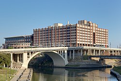
The University of Houston–Downtown (UHD) is a four-year state university, located within the historic First Ward. Founded in 1974, it is one of four separate and distinct institutions in the University of Houston System. UHD has an enrollment of 12,900 students—making it the 13th largest public university in Texas and the second-largest university in the Houston area. [16]

Religion

The Roman Catholic Archdiocese of Galveston-Houston operates nearby St. Joseph-St. Stephen Church in the 6th Ward. [17]

St. Stephen Church in the First Ward, which had a congregation with many Mexican immigrants, occupied what Lisa Gray of the Houston Chronicle referred to as "a modest church building" and was in an area experiencing gentrification. [18] It closed in 2016 when it was merged with St. Joseph Church. In 2018, [19] and 2019, there were protests advocating that the archdiocese reopen the church. The leadership of the Catholic church overruled the archdiocese and ordered the church to reopen, but as of 2019 no such reopening has yet occurred. [18]

See also

Related Research Articles

<span class="mw-page-title-main">River Oaks, Houston</span> Subdivision in Houston, Texas, USA

River Oaks is a residential community located in the center of Houston, Texas, United States. Located within the 610 Loop and between Downtown and Uptown, the community spans 1,100 acres (450 ha). Established in the 1920s by brothers Will Hogg and Michael Hogg, the community became a well-publicized national model for community planning. Real estate values in the community range from $1 million to over $20 million. River Oaks was also named the most expensive neighborhood in Houston in 2013. The community is home to River Oaks Country Club, which includes a golf course designed by architect Donald Ross and redesigned in 2015 by Tom Fazio.

<span class="mw-page-title-main">Downtown Houston</span> Neighborhood in Harris County, Texas, United States

Downtown is the largest central business district in the city of Houston and the largest in the state of Texas, located near the geographic center of the metropolitan area at the confluence of Interstate 10, Interstate 45, and Interstate 69. The 1.84-square-mile (4.8 km2) district, enclosed by the aforementioned highways, contains the original townsite of Houston at the confluence of Buffalo Bayou and White Oak Bayou, a point known as Allen's Landing. Downtown has been the city's preeminent commercial district since its founding in 1836.

<span class="mw-page-title-main">Heights High School</span> Public school (u.s.) school

Heights High School, formerly John H. Reagan High School, is a senior high school located in the Houston Heights in Houston, Texas. It serves students in grades nine through twelve and is a part of the Houston Independent School District.

<span class="mw-page-title-main">Second Ward, Houston</span>

Second Ward is a historical political district ward in the East End community in Houston, Texas. It was one of the four original wards of the city in the nineteenth century. The community known as the Second Ward today is roughly bounded by Buffalo Bayou to the north, Lockwood Avenue to the east, and railroad tracks to the south and west, although the City of Houston's "Super Neighborhood" program includes a section east of Lockwood.

Houston Heights is a community in northwest-central Houston, Texas, United States. "The Heights" is often referred to colloquially to describe a larger collection of neighborhoods next to and including the actual Houston Heights. However, Houston Heights has its own history, distinct from Norhill and Woodland Heights.

<span class="mw-page-title-main">Rice Military, Houston</span>

Rice Military is a neighborhood in Houston, Texas, United States. The Beer Can House is located in Rice Military.

<span class="mw-page-title-main">Oak Forest, Houston</span>

Oak Forest is a large residential community in northwest Houston, Texas, United States. Oak Forest is the third largest group of subdivisions in Harris County.

Eastwood is a historic neighborhood in the East End area of Houston, Texas, United States. Eastwood maintains Houston’s largest intact collection of Craftsman, Arts & Crafts, Foursquare and Mission style architecture.

<span class="mw-page-title-main">Third Ward, Houston</span> Neighborhood in Houston, Texas

Third Ward is an area of Houston, Texas, United States, that evolved from one of the six historic wards of the same name. It is located in the southeast Houston management district.

<span class="mw-page-title-main">Maplewood, Houston</span>

Maplewood is a community in Houston, Texas located outside the 610 Loop, southwest of Downtown Houston. It consists of 524 houses. They are one-story and two-story houses, as two stories is the limit allowed by the subdivision. The oldest houses were built in the early 1950s. Maplewood is located along Beechnut, Hillcroft, and Renwick.

<span class="mw-page-title-main">Woodland Heights, Houston</span> Historic Neighborhood in Houston, Texas

The Woodland Heights neighborhood is one of the oldest and most historic in Houston, Texas. It encompasses approximately 2000 homes in the 77009 ZIP code and is bounded on the north by Pecore Street, on the west by Studewood Street, on the east by I-45, and on the south by I-10.

Independence Heights is a community in Houston, Texas, bordered by 40th Street east of N. Main and 40th Street west of N. Main to the north, Yale Street to the west, the 610 Loop to the south, and Airline Drive to the east. The Super Neighborhood boundary created by the City of Houston is bordered by Tidwell to the north, Shepherd Drive to the west, the 610 Loop to the south, and Interstate 45 to the east.

<span class="mw-page-title-main">Fourth Ward, Houston</span> Historic district in Houston, Texas, United States of America

Fourth Ward is one of the historic six wards of Houston, Texas, United States. The Fourth Ward is located inside the 610 Loop directly west of and adjacent to Downtown Houston. The Fourth Ward is the site of Freedmen's Town, which was a post-U.S. Civil War community of African-Americans.

<span class="mw-page-title-main">Idylwood, Houston</span>

Idylwood is a historic neighborhood in the southeastern part of the I-610 loop in Houston, Texas. Idylwood, as of 2021, is the most expensive neighborhood in the East End. As of that year its houses were priced between $295,000 and $679,900. It currently has approximately 340 homes. Bill England, a redeveloper in the East End area, stated in 2004 that Idylwood appealed to buyers who are priced out of houses located in the cities of Bellaire and West University Place.

Riverside Terrace is a neighborhood in Houston, Texas, United States. It is along Texas State Highway 288 and north of the Texas Medical Center and located near Texas Southern University and University of Houston. There about 20 sections of Riverside Terrace that span across North and South MacGregor. The community, formerly an affluent Jewish neighborhood, became an affluent community for African Americans in the 1950s and '60s. It is still predominantly African American neighborhood with different income levels. It has been undergoing a gradual change in demographics and aesthetics due to gentrification efforts since the early 2000s.

<span class="mw-page-title-main">Sixth Ward, Houston</span>

The Sixth Ward is a community in Houston, Texas, United States, one of the city's historic wards.

<span class="mw-page-title-main">Lazybrook/Timbergrove, Houston</span>

Lazybrook and Timbergrove Manor are two adjoining, deed-restricted neighborhoods located approximately 7 miles northwest of Downtown Houston, Texas. Located inside the 610 Loop and just west of the Houston Heights, Lazybrook and Timbergrove Manor are situated along the wooded banks of White Oak Bayou in the near northwest quadrant of the city.

<span class="mw-page-title-main">Knollwood Village, Houston</span>

Knollwood Village is a subdivision in Houston, Texas. It is managed by the Knollwood Village Civic Club (KVCC), which governs Knollwood Village sections 1-10 and Braes Terrace II.

<span class="mw-page-title-main">Hyde Park, Montrose, Houston</span> Neighborhood in Houston, Texas, United States

Hyde Park is a historic community located in the Montrose neighborhood of Houston, Texas. Its southeast boundary is the intersection Montrose Boulevard and Westheimer. The neighborhood was established in the late 1800s on the summer farm of the second President of the Republic of Texas, Mirabeau Lamar. In the 1970s, Hyde Park became a central part of the Gay Rights Movement in Houston. Like much of Montrose, the neighborhood is now experiencing significant gentrification, and is home to an abundance of restaurants, including Mexican, Italian, Greek, American, Lebanese, coffee houses, and numerous bars.

References

  1. Plocek, Keith. "How Houston's Neighborhoods Got Their Names." Mentalfloss. Retrieved on September 21, 2016.
  2. Cobb, Kim. "Move afoot to train Houstonians to erase `ward' from vocabularies." Houston Chronicle . Saturday June 6, 1987. Section 1, Page 27. Retrieved on October 20, 2011.
  3. Spivak, Todd. "Brave New World: A Heights family is targeted in the name of progress." Houston Press . April 13, 2006. Retrieved on February 12, 2013.
  4. "High First Ward Historic District established." Houston Archaeological and Historical Commission. Retrieved September 21, 2016.
  5. Esquer, Nick. "Art on the Rise." Houstonia Magazine. Retrieved September 21, 2016.
  6. Mulvaney, Erin. "Subsidized lofts let artists 'follow their dreams'." Houston Chronicle. Retrieved September 21, 2016.
  7. Gonzales, Carolina. "The Haunted Jefferson Davis Hospital". Houston Chronicle. Retrieved September 21, 2016.
  8. de Luna, Marcy. "Developer has mega mixed-use plans for defunct downtown post office, call it Post HTX". CultureMap. Retrieved September 21, 2016.
  9. "Contact the Houston Fire Department". Retrieved September 21, 2016.
  10. "Clinic/Emergency/Registration Center Directory By ZIP Code". Harris County Hospital District. November 19, 2001. Archived from the original on November 19, 2001. Retrieved April 8, 2021. - See ZIP code 77007. See this map for relevant ZIP code.
  11. 1 2 "Crockett Elementary School Attendance Zone Archived September 30, 2007, at the Wayback Machine ." Houston Independent School District. Retrieved on November 29, 2010.
  12. "Hogg Middle Attendance Zone Archived February 27, 2009, at the Wayback Machine ." Houston Independent School District. Retrieved on November 29, 2010.
  13. "Reagan High School Attendance Zone Archived February 27, 2009, at the Wayback Machine ." Houston Independent School District. Retrieved on November 29, 2010.
  14. "School Histories: the Stories Behind the Names." Houston Independent School District .
  15. "Brock EL Boundary Map." Houston Independent School District. April 13, 2002. Retrieved on November 29, 2010.
  16. "Texas Higher Education Enrollments" (PDF). Texas Higher Education Coordinating Board. Retrieved March 15, 2009.
  17. "Home". St. Joseph-St. Stephen Church. Retrieved June 2, 2020. Saint Joseph Catholic Church Historic 6th Ward Houston Texas
  18. 1 2 Gray, Lisa (January 14, 2019). "St. Stephen faithful protest to have church reopened". Houston Chronicle . Retrieved June 2, 2020. St. Stephen,[...] is now surrounded by trendy breweries, art galleries and three-story townhomes.[Referring to gentrification]
  19. Gray, Lisa (December 24, 2018). "In Houston's gentrifying First Ward, immigrants fight to reopen their church". Houston Chronicle . Retrieved June 2, 2020.

Further reading