Westwood (subdivision), Houston

Last updated
Westwood Westwoodsubdivisionmarker.JPG
Westwood

Westwood is a residential subdivision in Southwest Houston, Texas. The subdivision is bounded by the 610 Loop, the Union Pacific railroad tracks, Stella Link Road, and Willowbend Boulevard. It has about 800 houses. [1]

Contents

Sergeant J. W. Collins of the Houston Police Department (HPD) Southwest Patrol Division and the head of the Beechnut Police Station's Tactical Response Team, stated that according to an HPD study of the crime statistics comparing those of January to May 1989 to January to May 1988, after the Link Valley complexes closed, Class 1 and Class 2 crime decreased in several neighborhoods. [note 1] In Westwood, Class 1 crime decreased by 3 percent and Class 2 crime decreased by 23%. [2]

In 2009 the civic club founded a Citizens on Patrol program. [1]

Education

Shearn Elementary School ShearnESHouston.JPG
Shearn Elementary School

The Houston Independent School District operates area public schools. [3] Shearn Elementary School and a park are in Section 4. [4] [5]

All houses are zoned to Shearn Elementary School and Pershing Middle School. [6] [7] Pershing-zoned students have the option to apply for the regular program at Pin Oak Middle School in the city of Bellaire. [8] Houses north of West Bellfort are zoned to Bellaire High School, which is also in the city of Bellaire. [9] Houses south of West Bellfort are zoned to Westbury High School. [10]

The Roman Catholic Archdiocese of Galveston-Houston operates Corpus Christi Catholic School in Westwood. [11] [12] Circa 2002 it had 137 students. From 2011 to 2012 enrollment grew by 7%, with 215 students to be enrolled in the 2012-2013 school year. By 2012 the school could not enroll all prospective students in each grade, with the filled-to-capacity grades having wait lists. [13]

History of education

In 1970 Westwood, along with some other White communities, was rezoned from Westbury to Madison High School because of a court ruling. By 1990, Westbury was about 50% Black, 25% White, 15% Hispanic, and 10% Asian while Madison was 1% White. In 1992 an attendance boundary shift occurred but Westwood was still in the Madison zone. The residents wanted to be rezoned to Westbury. Rod Paige, then the board president and HISD trustee for district 9, and board member Donald R. McAdams attended a meeting at a house of a Westwood community leader on May 12, 1992. [14]

McAdams, who authored Fighting to Save Our Urban Schools-- and Winning!: Lessons from Houston, recalled that the Westwood residents said "Westwood is an integrated community. Whites, blacks,[ sic ] Hispanics, and Asians live happily together in almost perfect balance. All of us want to be rezoned from Madison to Westbury. Westbury is our neighborhood high school. It is closer than Madison." [15] McAdams wrote that the demographics of the community meeting confirmed the statement about ethnic diversity. [16] According to McAdams, HISD superintendent Frank Petruzielo initially did not adopt the recommendations from himself and Paige because he feared black administrators in HISD would not support the move, so McAdams and Westwood community leaders made a presentation to the HISD board explaining the merits of the case. The board unanimously rezoned the community to Westbury. [16]

Parks and recreation

The City of Houston operates Westwood Park, located in Section 4. [4] [17]

Infrastructure

Harris Health System (formerly Harris County Hospital District) designated Martin Luther King Health Center in southeast Houston for ZIP code 77025. The nearest public hospital is Ben Taub General Hospital in the Texas Medical Center. [18]

Related Research Articles

<span class="mw-page-title-main">Bellaire, Texas</span> Enclave city in Texas, United States

Bellaire is a city in southwest Harris County, Texas, United States, within the Houston–Sugar Land–Baytown metropolitan area. As of the 2020 U.S. census, the city population was 17,202. It is surrounded by the cities of Houston and West University Place. Bellaire is known as the "City of Homes", owing to its mostly residential character; but it has offices along the I-610 Loop within the city limits.

<span class="mw-page-title-main">Bellaire High School (Texas)</span> Public secondary school in Bellaire, Texas, United States

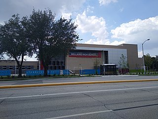
Bellaire High School is a comprehensive, public secondary school in Bellaire, Texas. Part of the Houston Independent School District, it serves the incorporated city of Bellaire, the Houston community of Meyerland, and other adjacent Houston neighborhoods. It has a racially and socioeconomically diverse student body.

<span class="mw-page-title-main">Bob Lanier Middle School</span> Public school in Houston, Texas

Bob Lanier Middle School, formerly Sidney Lanier Junior High School/Middle School, is a middle school in Houston, Texas, United States, with a ZIP code of 77098. Lanier, a school of the Houston Independent School District (HISD), handles grades 6 through 8. Named after former mayor of Houston Bob Lanier, the school is located in Neartown and near Montrose and has both neighborhood non-magnet and Vanguard/IBMYP gifted/talented programs. Lanier's neighborhood program serves Montrose, Afton Oaks, Boulevard Oaks, River Oaks, Southampton, and other communities.

<span class="mw-page-title-main">Westbury, Houston</span>

Westbury is a neighborhood in the Brays Oaks district of Southwest Houston, Texas, United States. It is located east of Bob White Road, north of U.S. Highway 90 Alternate, and west of South Post Oak Road, adjacent to the Fondren Southwest and Meyerland neighborhoods, just west of the southwest corner of the 610 Loop.

<span class="mw-page-title-main">Lamar High School (Houston)</span> American public high school

Lamar High School is a comprehensive public secondary school located in Houston, Texas, United States. It is a part of the Houston Independent School District (HISD). Lamar High School, was established in 1936 in memory of Mirabeau B. Lamar (1798–1859), a leader in the Texas Revolution and the second President of the Republic of Texas. Lamar has a four-year program, serving grades 9 through 12.

<span class="mw-page-title-main">Pershing Middle School (Houston)</span> Middle school in Houston, Texas

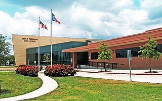
John J. Pershing Middle School is a middle school in Houston, Texas, United States. It is located in the Braeswood Place neighborhood, near the Texas Medical Center.

<span class="mw-page-title-main">Heights High School</span> Public school (u.s.) school

Heights High School, formerly John H. Reagan High School, is a senior high school located in the Houston Heights in Houston, Texas. It serves students in grades nine through twelve and is a part of the Houston Independent School District.

<span class="mw-page-title-main">Westbury High School (Houston)</span> High school in Brays Oaks, Texas

Westbury High School is a secondary school located in the Brays Oaks, of Southwest Houston, Texas, near the Westbury neighborhood. It has grades 9 through 12, and is part of the Houston Independent School District. In 2019, Jerri Nixon succeeded Susan Monaghan as principal, who had retired.

<span class="mw-page-title-main">Meyerland, Houston</span> Community in Houston, Texas

Meyerland is a community in southwest Houston, Texas, outside of the 610 Loop and inside Beltway 8. The neighborhood is named after the Meyer family, who bought and owned 6,000 acres (24 km²) of land in southwest Houston.

Houston Heights is a community in northwest-central Houston, Texas, United States. "The Heights" is often referred to colloquially to describe a larger collection of neighborhoods next to and including the actual Houston Heights. However, Houston Heights has its own history, distinct from Norhill and Woodland Heights.

<span class="mw-page-title-main">Braeswood Place, Houston</span>

Braeswood Place is a group of subdivisions in Harris County, Texas, United States. The vast majority of the land is in Houston while a small part is in Southside Place.

<span class="mw-page-title-main">Afton Oaks, Houston</span>

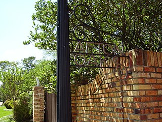
Afton Oaks is a deed-restricted "Inner Loop" upscale residential community of approximately 525 homes in Houston, Texas, United States. Afton Oaks is located inside Interstate 610 near the Galleria and Highland Village. The neighborhood is bounded on the north by Westheimer Road, on the east by Union Pacific railroad tracks, on the south by Interstate 69/U.S. Highway 59, and on the west by Interstate 610.

<span class="mw-page-title-main">Wheatley High School (Houston)</span> School

Phillis Wheatley High School is a secondary school located at 4801 Providence Street in Houston, Texas, United States with a ZIP code of 77020. Wheatley is a part of the Houston Independent School District. Wheatley, named after Phillis Wheatley, is located inside the 610 Loop in the Fifth Ward.

<span class="mw-page-title-main">Willow Meadows, Houston</span>

Willow Meadows is a subdivision in Houston, Texas, United States.

<span class="mw-page-title-main">Willowbend, Houston</span>

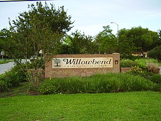
Willowbend is a neighborhood in near Southwest Houston, Texas.

<span class="mw-page-title-main">Madison High School (Houston)</span> Public school in Houston, Texas, United States

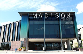
James Madison High School is a public high school located in the Hiram Clarke area of Houston, Texas, United States. The school, located in the Five Corners District, serves grades 9 through 12 and is part of the Houston Independent School District. The school is named after James Madison, the fourth President of the United States.

Manchester is a community in southeastern Houston, Texas, United States.

Kashmere Gardens is a historically African-American neighborhood in the northern 610 Loop area in Houston, Texas, United States. A group of single-family houses, many of which have large lots, Kashmere Gardens is between an industrial area and a rail corridor.

Robindell is a subdivision in Southwest Houston, Texas.

References

Notes

  1. 1 2 Jackson, Kim. "Westwood Civic Club forms Citizens on Patrol program." Houston Chronicle . August 25, 2009. Retrieved on November 4, 2013.
  2. 1 2 Cobb, Kim. "HPD reports less crime near Link Valley." Houston Chronicle . Friday July 1, 1989. p. A32. Available from NewsBank, Record Number: 07*21*638242. Article available from the Houston Public Library website with a library card.
  3. Section 1Sections 2-4: Section 5:
  4. 1 2 "Westwood Sec. 4" (JPG, PDF). Harris County Assessor's Block Book Maps. Volume 77, Page 174B. Retrieved on July 26, 2017. Shearn Elementary was built where "Reserve B" ("School") is indicated.
  5. Home. Shearn Elementary School. Retrieved on July 26, 2017. "9802 Stella Link Rd. Houston, TX 77025-4605"
  6. "Shearn Elementary Attendance Zone," Houston Independent School District
  7. "Pershing Middle Attendance Zone," Houston Independent School District
  8. "Pin Oak Middle School." The Southwest District. Houston Independent School District.
  9. "Bellaire High School Attendance Zone." Houston Independent School District .
  10. "Westbury High School Attendance Zone," Houston Independent School District
  11. Assessor's Block Book for Harris County, Texas. Vol. 80. Harris County Appraisal District. p. 77. - "Westwood Section 5 Blocks 1-9 and Res. A-D" JPG - The school is on tract "A".
  12. "Map and Directions". Corpus Christi Catholic School. Retrieved 2020-06-06. 4005 Cheena Dr, Houston, TX 77025
  13. Rhor, Monica (2012-08-15). "Houston Catholic school enrollment strong and growing". Houston Chronicle . Retrieved 2020-06-06. 215 students - an increase of about 7 percent from last year.[...]Just 10 years ago, the school had 137 students;[...]
  14. McAdams, p. 55.
  15. McAdams, p. 55-56.
  16. 1 2 McAdams, p. 56.
  17. "Our Parks O-Z." City of Houston. Retrieved on July 30, 2017. "Westwood Park 4045 Lemac, 77025"
  18. "Clinic/Emergency/Registration Center Directory By ZIP Code". Harris County Hospital District. 2001-11-19. Archived from the original on 2001-11-19. Retrieved 2021-04-08. - See ZIP code 77025. See this map for relevant ZIP code.

Numbered notes

  1. Crimes such as aggravated assault, burger, manslaughter, murder, rape, and robbery were classified as Class 1 offenses. Crimes such as assault, embezzlement, forgery, gambling, and narcotics were classified as Class 2 offenses. [2]

Coordinates: 29°40′39″N95°33′25″W / 29.6775°N 95.5570°W / 29.6775; -95.5570