The Fium'Albino is a small coastal river in the departments of Corse-du-Sud and Haute-Corse, Corsica, France. Its mouth opens into the Gulf of St Florent in the Mediterranean Sea on the west of the Cap Corse peninsula.
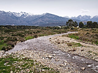
The Fium'Albino is 7.68 kilometres (4.77mi) long. It crosses the communes of Farinole and Patrimonio.[1] It forms from several streams that originate on the western slope of the ridge that forms the backbone of Cap Corse, and that meet to the east of the town of Patrimonio.[2] The Ruiseau de Serpaio rises to the west of the 839 metres (2,753ft) Monte San Columbano. It joins the Ruisseau di Monti Rossi to form the Fium'Albino. This flows in a generally southwest direction past the town of Patrimonio then northwest to enter the sea beside Punta di Saeta.[3]
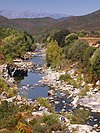
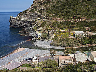
The Fium'Albino enters the Gulf of St-Laurent downstream from the Ponte Albino. From this point, a steep limestone ridge contains the south of the lower valley, and ends in the rocky headland Punta di Saeta. The Fium Albino flows intermittently, but downstream of the Ponte Albino it resembles a wadi with only seasonal surface runoff. In this section, the stream cuts through an old alluvial terrace made up of pebbles and blocks covered with a layer of finer alluvium. It has a pebble bed, and there are pebble beaches on both sides of its estuary, which is replaced by sand to the northeast.[2]
Geology
The river gives its name to the Fium Albino Formation, which outcrops in the Saint-Florent region and at Francardo. This was formed in the late early Miocene and early middle Miocene and consists of fluvial deposits of Alpine-derived detritus, with subordinate foreland-derived volcanic detritus.[4] It is found in depressions cut by erosion into the underlying Nebbio nappe, and consists of pebble conglomerate and very coarse- to coarse-grained sandstone.[5] The formation is found inland in a narrow strip that crosses the river from north to south. The lower course of the river runs through the Torra and Monte Sant'Angelo Formation, where carbonate intrabasinal detritus predominates. Above the Fium Albino Formation are rocks of the Late Carboniferous–Permian Volcanic Succession and finally Upper Schistes Lustrés in the higher land.[6]
Hydrology
Between 2012 and 2021, the river was observed between May and September from the RD333 bridge. Once in June and three times in August the river had dried up. Four more times in August or September there was no discernible flow.[7]
Environment
"Ponte Albino et abords" has been designated as a Zone naturelle d'intérêt écologique, faunistique et floristique (ZNIEFF). This includes the last part of the lower valley of Fium Albino and the limestone slope which overhangs it on the left (south) bank from Ponte Albino.[2]
In October 1981, Bogidiella cyrnensis, a new amphipoda species of the family Bogidiellidae was found in fine gravel and silt in the river bed under the D333 road bridge.[8] The specific name cyrnensis refers to Cyrnos (Kûpvoç), the classical Greek name for Corsica.[9]
Tributaries
The following streams (ruisseaux) are tributaries of the Fium'Albino (ordered by length):[1]
Barbaggio is a commune in the French department of Haute-Corse on the island of Corsica. It is known for its wine, its scenery, and the prehistoric site of Strette.
The Aglia is a 9 kilometres (5.6 mi) long stream in the department of Haute-Corse, Corsica, a tributary of the Abatesco.
The Étang de Diane is a coastal lagoon beside the Tyrrhenian Sea on the east coast of Haute-Corse department on the French island of Corsica. The lagoon served as a port for the Ancient Greeks, and then for the Romans. Today it is privately owned and mainly used for shellfish farming and fishing.
The Étang de Crovani is a coastal lagoon beside the Mediterranean Sea on the west coast of the Haute-Corse department on the French island of Corsica.
Monte Astu or Monte Asto is a mountain in the department of Haute-Corse on the island of Corsica, France.
The Col de Bigorno Corsican: Bocca di Bigornu), or Bigorno Pass, is a mountain pass in the Haute-Corse department of Corsica, France.
Lac de Calacuccia is a reservoir in the Haute-Corse department of France formed by damming the Golo river. It provides hydroelectric power and water for irrigation in the dry season.
The Asco is a small river in the department of Haute-Corse, Corsica, France. It is a tributary of the Golo. The river rises in the Monte Cinto massif among some of the highest mountains of Corsica, passes a ski resort and the old village of Asco and cuts through a dramatic 4 kilometres (2.5 mi) gorge before joining the Golo.
The Tartagine is a river in the department of Haute-Corse, Corsica, France. It flows through the Monte Cinto massif. It is a tributary of the Asco, which in turn is a tributary of the Golo.
The Casaluna is a small river in the department of Haute-Corse, Corsica, France. It is a tributary of the Golo.
The Regino River is a small coastal river in the department of Haute-Corse, Corsica, France.
The Sisco is a small coastal stream in the department of Haute-Corse, Corsica, France. It enters the Tyrrhenian Sea from the east of the Cap Corse peninsula.
The Porto is a small coastal river in the northwest of the department of Corse-du-Sud, Corsica, France.
The Buggiu or Valdolese, Vughio is a small coastal river in the department of Haute-Corse, Corsica, France. It flows into the Golfe de Saint-Florent in the north of the island. The estuary at its mouth has ecological value.
The Santu River is a small coastal river in the department of Haute-Corse, Corsica, France.
The Seccu River is a small coastal river in the department of Haute-Corse, Corsica, France.
The Poggiolo is a small coastal stream in the department of Haute-Corse, Corsica, France. It enters the Tyrrhenian Sea from the east of the Cap Corse peninsula.
The Guadu Grande is a small coastal stream in the department of Haute-Corse, Corsica, France. It enters the Mediterranean Sea from the west of the Cap Corse peninsula.
The Olmeta is a small coastal stream in the department of Haute-Corse, Corsica, France. It enters the Mediterranean Sea from the west of the Cap Corse peninsula.
The Col de Santo Stefano Corsican: Bocca di San Stefanu) is a mountain pass in the Haute-Corse department of Corsica, France. It is one of the main passes in Corsica, running between the massifs of Monte Stello to the north and Monte Astu to the south. It provides a route from the Saint-Florent region to the northwest and Biguglia in the eastern coastal plain.
This page is based on this Wikipedia article Text is available under the CC BY-SA 4.0 license; additional terms may apply. Images, videos and audio are available under their respective licenses.