Forest, Texas

Last updated

Forest, Texas
USA Texas location map.svg
Red pog.svg
Forest
Location within the state of Texas
Usa edcp location map.svg
Red pog.svg
Forest
Forest (the United States)
Coordinates: 31°30′57″N95°0′42″W / 31.51583°N 95.01167°W / 31.51583; -95.01167
Country United States
State Texas
County Cherokee
Elevation
296 ft (90 m)
Time zone UTC-6 (Central (CST))
  Summer (DST) UTC-5 (CDT)
Area code 430 & 903
GNIS feature ID2034940 [1]

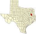
Forest is a community located in southeastern Cherokee County, Texas, United States. [1] According to the Handbook of Texas, the community had a population of 85 in 2000. It is located within the Tyler-Jacksonville combined statistical area.

Contents

History

In 1847, Wiley Thompson had opened the first businesses, consisting of a store, saloon, watermill, gristmill, and cotton gin on Larrison Creek. It was given the name Forest because a traveler was resting under a tree and was there "for rest". The first postmaster of Forest was appointed in 1879. The Forest Baptist Church was established in 1888 with a pastor surnamed Rushing. During the 1920s and 1930s, the Forest area produced tomatoes, and two tomato packing sheds were built beside the St. Louis Southwestern Railway of Texas. The post office was transferred to Wells in 1887, was routed back to the community that same year, then permanently changed to Wells in 1980. As of the 1980s, Forest is mostly a cattle community, and its only store is in and out of business. Forest's population was reported as around 100 in the early twentieth century. In the 1950s, the population rose to its peak of 120. By 2000, it had dropped to 85. [2]

Geography

Forest is located on Farm to Market Road 1911, 10 mi (16 km) south of Alto in southeastern Cherokee County. [2]

Education

Forest is served by the Wells Independent School District.

Related Research Articles

<span class="mw-page-title-main">Sallisaw, Oklahoma</span> City in Oklahoma, United States

Sallisaw is a city and county seat in Sequoyah County, Oklahoma, United States. As of the 2010 Census, it had a population of 8,880, an 11.2 percent increase over the figure of 7,891 recorded in 2000. Sallisaw is part of the Fort Smith, Arkansas–Oklahoma Metropolitan Statistical Area.

<span class="mw-page-title-main">Wells, Texas</span> Town in Texas, United States

Wells is a town in Cherokee County, Texas, United States. The population was 790 at the 2010 census, and 853 at the 2020 U.S. census.

Cherokee is an unincorporated community in San Saba County in western Central Texas. According to the Handbook of Texas, the community had an estimated population of 175 in 2000.

<span class="mw-page-title-main">Reese, Texas</span> Unincorporated community in Texas, United States

Reese is a rural unincorporated community in Cherokee County, in the U.S. state of Texas, situated in the East Texas region. Its population was last estimated at 75, but no current U.S. Census data is available. It is located within the Tyler-Jacksonville combined statistical area.

Mount Selman is an unincorporated community in Cherokee County, Texas, United States. According to the Handbook of Texas, the community had a population of 200 in 2000. It is located within the Tyler-Jacksonville combined statistical area.

Mixon is a small unincorporated community in northern Cherokee County, Texas, United States. According to the Handbook of Texas, the community had a population of 50 in 2000. It is located within the Tyler-Jacksonville combined statistical area.

Dialville is a small unincorporated community in north-central Cherokee County, Texas, United States. According to the Handbook of Texas, the community had a population of 200 in 2000. It is located within the Tyler-Jacksonville combined statistical area.

Ponta is a small unincorporated community in eastern Cherokee County, Texas, United States. According to the Handbook of Texas, the community had a population of 50 in 2000. It is located within the Tyler-Jacksonville combined statistical area.

Craft is a small unincorporated community in central Cherokee County, Texas, United States. According to the Handbook of Texas, the community had a population of 21 in 2000. It is located within the Tyler-Jacksonville combined statistical area.

Oakland is an unincorporated community in Cherokee County, located in the U.S. state of Texas. According to the Handbook of Texas, the community had a population of 50 in 2000. It is located within the Tyler-Jacksonville combined statistical area.

Linwood is an unincorporated community in Cherokee County, located in the U.S. state of Texas. According to the Handbook of Texas, the community had a population of 40 in 2000. It is located within the Tyler-Jacksonville combined statistical area.

Ironton is an unincorporated community in Cherokee County, located in the U.S. state of Texas. According to the Handbook of Texas, the community had a population of 110 in 2000. It is located within the Tyler-Jacksonville combined statistical area.

Shady Grove is an unincorporated community in Cherokee County, located in the U.S. state of Texas. According to the Handbook of Texas, the community had a population of 30 in 2000. It is located within the Tyler-Jacksonville combined statistical area.

Gould is an unincorporated community in Cherokee County, located in the U.S. state of Texas. According to the Handbook of Texas, the community had a population of 20 in 2000. It is located within the Tyler-Jacksonville combined statistical area.

Blackjack is an unincorporated community in Cherokee County, located in the U.S. state of Texas. According to the Handbook of Texas, the community had a population of 47 in 2000. It is located within the Tyler-Jacksonville combined statistical area.

New Hope is an unincorporated community in Cherokee County, located in the U.S. state of Texas. According to the Handbook of Texas, the community had a population of 50 in 2000. It is located within the Tyler-Jacksonville combined statistical area.

Prairieville is an unincorporated rural small village in Kaufman County, Texas, United States. There is a grocery store at Prairieville, a church, and several homes. According to the Handbook of Texas, the community had a population of 50 in 2000. It is located within the Dallas-Fort Worth metropolitan area.

Central High is an unincorporated community in Cherokee County, located in the U.S. state of Texas. According to the Handbook of Texas, the community had a population of 30 in 2000. It is located within the Tyler-Jacksonville combined statistical area.

Circle is an unincorporated community in Cherokee County, located in the U.S. state of Texas. According to the Handbook of Texas, there were no population estimates available for the community in 2000. It is located within the Tyler-Jacksonville combined statistical area.

Pine Grove is an unincorporated community in Cherokee County, located in the U.S. state of Texas. According to the Handbook of Texas, the community had a population of 30 in 2000. It is located within the Tyler-Jacksonville combined statistical area.

References

  1. 1 2 U.S. Geological Survey Geographic Names Information System: Forest, Texas
  2. 1 2 Aswell, Phyllis. "Forest, TX". tshaonline.org. Retrieved December 25, 2022.