The Fort Worth Stockyards is a historic district that is located in Fort Worth, Texas, United States, north of the central business district. A 98-acre (40 ha) portion encompassing much of the district was listed on the National Register of Historic Places as Fort Worth Stockyards Historic District in 1976. It holds a former livestock market which operated under various owners from 1866.

The Strip District is a neighborhood in Pittsburgh, Pennsylvania, United States. It is a one-half square mile area of land northeast of the central business district bordered to the north by the Allegheny River and to the south by portions of the Hill District. The Strip District runs between 11th and 33rd Streets and includes four main thoroughfares—Railroad Street/Waterfront Place, Smallman Street, Penn Avenue, and Liberty Avenue—as well as various side streets.

The Washington Avenue Historic District is located in Downtown West, St. Louis, Missouri along Washington Avenue, and bounded by Delmar Boulevard to the north, Locust Street to the south, 8th Street on the east, and 18th Street on the west. The buildings date from the late 19th century to the early 1920s. They exhibit a variety of popular architectural styles of those years, but most are revival styles or in the commercial style that would later come to be known as the Chicago School of architecture. Most are large multi-story buildings of brick and stone construction, built as warehouses for the St. Louis garment district. Many have terra cotta accents on their facades. After World War II, the decline in domestic garment production and the preference for single-story industrial space led to many of the buildings being vacant or underused due to functional obsolescence.
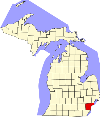
This is a list of the National Register of Historic Places listings in Wayne County, Michigan.

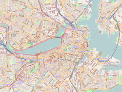
Long Wharf is a historic American pier in Boston, Massachusetts, built between 1710 and 1721. It once extended from State Street nearly a half-mile into Boston Harbor; today, the much-shortened wharf functions as a dock for passenger ferries and sightseeing boats.

Fort Point is a neighborhood or district of Boston, Massachusetts, and where a fort stood which guarded the city in colonial times.

The Omaha Rail and Commerce Historic District, roughly bounded by Jackson, 15th, and 8th Streets, as well as the Union Pacific main line, is located in downtown Omaha, Nebraska. Today this historic district includes several buildings listed individually on the National Register of Historic Places, including the Union Pacific Depot and the Burlington Station.

Custom House District is a historic district in Boston, Massachusetts, located between the Fitzgerald Expressway and Kilby Street and South Market and High and Batterymarch Streets. Named after the 1849 Boston Custom House located on State Street, the historic district contains about seventy buildings on nearly sixteen acres in Downtown Boston, consisting of 19th-century mercantile buildings along with many early 20th-century skyscrapers, including the 1915 Custom House Tower.

This is a list of the National Register of Historic Places listings in Detroit, Michigan.
Prairie Avenue is a north–south street on the South Side of Chicago, which historically extended from 16th Street in the Near South Side to the city's southern limits and beyond. The street has a rich history from its origins as a major trail for horseback riders and carriages. During the last three decades of the 19th century, a six-block section of the street served as the residence of many of Chicago's elite families and an additional four-block section was also known for grand homes. The upper six-block section includes part of the historic Prairie Avenue District, which was declared a Chicago Landmark and added to the National Register of Historic Places.

The Crescent Warehouse Historic District is a 10.5-acre (4.2 ha) historic district in Downtown Davenport, Iowa, United States. The district is a collection of multi-story brick structures that formerly housed warehouses and factories. Most of the buildings have been converted into loft apartments. The district was listed on the National Register of Historic Places in 2003.

The Linograph Company Building, also known as the Englehart Manufacturing Company Building and RiverWalk Lofts , is a historic building located in downtown Davenport, Iowa, United States. It was listed on the Davenport Register of Historic Properties and on the National Register of Historic Places in 2009.

Stephen Decatur Hatch (1839–1894) was a prominent late-19th century architect who was responsible for a number of historically or architecturally significant buildings in Manhattan, New York City and elsewhere. He primarily designed commercial buildings.

The Means Street Historic District in the Marietta Street Artery district of Atlanta consists of historic, mostly 19th and early 20th century warehouse and industrial buildings now converted to office space along one block of Means St. between Bankhead and Ponders Aves. Means Street was named for landowner Alexander Means and was plotted in 1869. Warehouses were built in this early industrial corridor, then known as Bellwood, along the railroad line. Mule-pulled trolleys brought workers starting in 1882, and these became electrified in 1894.

The Wisconsin Wagon Company Factory is a historic factory building located at 602 Railroad Street in Madison, Wisconsin. The Wisconsin Wagon Company built the factory building in 1903 to construct horse-drawn wagons and carriages. The company transitioned the building to an auto factory in 1917 and continued to use it until 1957. The building is a well-preserved example of a textile mill industrial loft, a popular factory style in many industries around the turn of the century. It was added to the National Register of Historic Places in 2002.

This is a list of the National Register of Historic Places listings in Downtown and Midtown Detroit, Michigan. It is intended to be a complete list of the properties and districts on the National Register of Historic Places in Downtown and Midtown neighborhoods in Detroit, Michigan, United States. Latitude and longitude coordinates are provided for many National Register properties and districts; these locations may be seen together in online maps.

Washington Avenue Historic District, or Washington Avenue Factory District, is a national historic district located in the Hawthorne and Bella Vista neighborhoods of South Philadelphia, Pennsylvania. It comprises the remaining four blocks of one of the last industrial neighborhoods in Philadelphia, and encompasses eight contributing buildings built between 1889 and 1927:

Sohmer and Company Piano Factory is a historic piano factory located in the Astoria neighborhood of Queens, New York City. It was built in 1886 by Sohmer & Co., and is a six-story, L-shaped, Rundbogenstil / Romanesque Revival style brick building. The corner features a clock tower with a copper trimmed mansard roof. The building was expanded about 1906–1907. It was converted to residential usage starting in 2007.

Central Wharf is a historic pier in Boston, Massachusetts. Built in 1815–1816 between Long Wharf and India Wharf, it originally extended from India Street nearly a quarter-mile into Boston Harbor. Today, the much-shortened wharf serves as the home of the New England Aquarium.
John Street is a street running west to east through the Financial District of Lower Manhattan in New York City. It is one of the oldest streets in the city. Long associated with maritime activity, the street ran along Burling Slip. The slip was filled in around 1840, and the street widened. Besides a wharf, warehouse, and chandlery, the city's first permanent theatre, and the first Methodist congregation in North America were located on John Street. It was also the site of a well-known pre-Revolutionary clash between the Sons of Liberty and British soldiers, pre-dating the Boston Massacre by six weeks.