South Station, officially The Governor Michael S. Dukakis Transportation Center at South Station, is the largest railroad station and intercity bus terminal in Greater Boston and New England's second-largest transportation center after Logan International Airport. Located at the intersection of Atlantic Avenue and Summer Street in Dewey Square, Boston, Massachusetts, the historic station building was constructed in 1899 to replace the downtown terminals of several railroads. Today, it serves as a major intermodal domestic transportation hub, with service to the Greater Boston region and the Northeastern and Midwestern United States. It is used by thousands of commuter rail and intercity rail passengers daily. Connections to the rapid transit Red Line and bus rapid transit Silver Line are made through the adjacent subway station.

South Boston is a densely populated neighborhood of Boston, Massachusetts, United States, located south and east of the Fort Point Channel and abutting Dorchester Bay. It has undergone several demographic transformations since being annexed to the city of Boston in 1804. The neighborhood, once primarily farmland, is popularly known by its twentieth century identity as a working class Irish Catholic community. Throughout the twenty-first century, the neighborhood has become increasingly popular with millennial professionals.

The Old South Meeting House is a historic Congregational church building located at the corner of Milk and Washington Streets in the Downtown Crossing area of Boston, Massachusetts, built in 1729. It gained fame as the organizing point for the Boston Tea Party on December 16, 1773. Five thousand or more colonists gathered at the Meeting House, the largest building in Boston at the time.

Congress Street Grounds is a former baseball ground located in Boston, Massachusetts. The ballpark, as the name implies, was along Congress Street, near the intersection of Thompson Place, and not far from the Fort Point Channel on South Boston Flats, a newly filled in piece of land on Boston Harbor. The ground was home to the Boston Reds, that played in the Players' League in 1890 and the American Association in 1891.

The Old State House, also known as the Old Provincial State House, is a historic building in Boston, Massachusetts, built in 1713. It was the seat of the Massachusetts General Court until 1798. It is located at the intersection of Washington and State Streets and is one of the oldest public buildings in the United States.
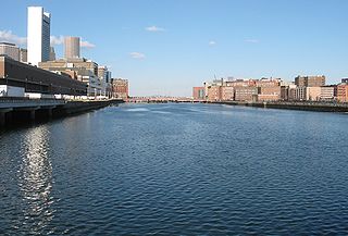
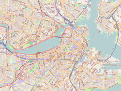
Fort Point Channel is a maritime channel separating South Boston from Downtown Boston, feeding into Boston Harbor. The south part of it has been gradually filled in for use by the South Bay rail yard and several highways. At its south end, the channel once widened into South Bay, from which the Roxbury Canal continued southwest where the Massachusetts Avenue Connector is now. The Boston Tea Party occurred at its northern end. The channel is surrounded by the Fort Point neighborhood, which is also named after the same colonial-era fort.
Winter Island is an island connected by a causeway to Salem Neck in Salem, Massachusetts. It is about 45 acres (18 ha) in size, and is bounded by Smith Pool to the northwest, Cat Cove to the west, Salem Channel to the south and east, and Juniper Cove to the north. The island has about a dozen residences at the north end and one road, Winter Island Road. The Plummer Home for Boys sits on 18 acres (7.3 ha) of land on the northeastern shore. The balance of the island is Winter Island Marine Park. The entire island was added to the National Register of Historic Places as Winter Island Historic District and Archeological District in 1994.

Fort Point is a neighborhood or district of Boston, Massachusetts, and where a fort stood which guarded the city in colonial times.

Harrison Henry Atwood was an American architect and politician who represented Boston in the United States House of Representatives from 1895 to 1897 and for several nonconsecutive terms in the Massachusetts House of Representatives. He was a member of the Republican Party but was also supported by the Progressive Party during his later terms in the Massachusetts House.

The Chestnut Hill Reservoir Historic District is a historic district encompassing the Chestnut Hill Reservoir and the surrounding water works facilities which were historically used to provide fresh water to Boston, Massachusetts, and surrounding towns. The district is nearly coextensive with the Chestnut Hill Reservation, a state park managed by the Massachusetts Department of Conservation and Recreation (DCR); those elements of the water works that are still required as an emergency backup are managed by the Massachusetts Water Resources Authority (MWRA). The reservoir is located between Beacon Street and Commonwealth Avenue in Boston's Chestnut Hill district, just east of the Boston College Main Campus Historic District.

Dorchester Temple Baptist Church is a historic African American Baptist church at 670 Washington Street in Boston, Massachusetts. It is now known as Global Ministries Christian Church.

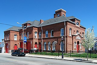
The Fort Point Channel Historic District is an historic district located along Congress, Summer and A streets in South Boston on the south side of Fort Point Channel.
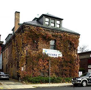
The Harvard Avenue Fire Station is a historic former fire station on 16 Harvard Avenue in Boston, Massachusetts. The station was designed in 1891 by Harrison H. Atwood, the Boston city architect who also designed the Congress Street Fire Station, It is a hip-roofed two story brick structure with Renaissance and Classical Revival elements. It was the second firehouse built on the site, and housed Engine #41 and Hook and Ladder #14.

The New England Confectionery Company Factory, also known as the NECCO Candy Factory, is a historic factory complex at 250 Massachusetts Avenue in Cambridge, Massachusetts. The property is now owned by DFS Advisors, and is under long-term lease to Novartis. The complex, which includes the factory building, a power plant, and a modern (2003) parking garage, occupies most of an entire city block bounded by Massachusetts Avenue, Cross Street, Albany Street, and Lansdowne Street. The Moderne-style building was constructed of reinforced concrete, faced predominantly with beige brick and trimmed with limestone. On some facades smooth concrete predominates as the finish surface. The building had a water tower that was painted to resemble a roll of Necco Wafers; during the alterations of the property for use by Novartis, the water tower was retained, and is now painted with a DNA pattern in pastel colors. The building was listed on the National Register of Historic Places in 2005.
Pocasset Firehouse No. 7 is a historic former fire station in Fall River, Massachusetts. Built in 1873, it is one of four extant firehouses within the city designed by Boston architects Hartwell & Swasey in the Ruskinian Gothic style. The others include the Quequechan No. 1 on Prospect Street, the Massasoit No. 5 on Freedom Street, the Anawan No. 6 Firehouse on North Main Street.

Summer Street in Boston, Massachusetts, extends from Downtown Crossing in the Financial District, over Fort Point Channel, and into the Seaport District to the southeast. In the mid-19th century it was also called Seven Star Lane. Seven Star Lane was named so for "Seven Stars," a tavern once located at the northwest corner of Summer and Hawley streets.

Congress Street in Boston, Massachusetts, is located in the Financial District and South Boston. It was first named in 1800. It was extended in 1854 as far as Atlantic Avenue, and in 1874 across Fort Point Channel into South Boston. Today's Congress Street consists of several segments of streets, previously named Atkinson's Street, Dalton Street, Gray's Alley, Leverett's Lane, Quaker Lane, and Shrimpton's Lane.
This is a timeline of the history of the city of Salem, Massachusetts, United States.

The Charlestown Main Street Historic District encompasses the historic heart of Charlestown, New Hampshire. It is located along Main Street, roughly between Lower Landing Road and Bridge Street, and encapsulates more than two hundred years of the town's history. The district was listed on the National Register of Historic Places in 1987.

Fort Hill is a 0.4 square mile neighborhood and historic district of Roxbury, in Boston, Massachusetts. The approximate boundaries of Fort Hill are Malcolm X Boulevard on the north, Washington Street on the southeast, and Columbus Avenue on the southwest.