Fort Riley (CDP), Kansas

Last updated

Fort Riley, Kansas
Fort Riley North
CDP
Riley County Kansas Incorporated and Unincorporated areas Fort Riley North Highlighted.svg
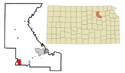
Location within Riley County and Kansas
Coordinates: 39°5′18″N96°48′51″W / 39.08833°N 96.81417°W / 39.08833; -96.81417 [1]
Country United States
State Kansas
Counties Riley, Geary
Area
  Total5.05 sq mi (13.07 km2)
  Land5.03 sq mi (13.04 km2)
  Water0.008 sq mi (0.02 km2)
Elevation
[1]
1,309 ft (399 m)
Population
 (2020) [2]
  Total9,230
  Density1,800/sq mi (710/km2)
Time zone UTC-6 (CST)
  Summer (DST) UTC-5 (CDT)
Area code 785
FIPS code 20-23975 [1]
GNIS ID 2393004 [1]

Fort Riley is a census-designated place (CDP) in Geary and Riley counties in the U.S. state of Kansas, on the grounds of Fort Riley. [1] As of the 2020 census, the population was 9,230. [2] Fort Riley is part of the Manhattan, Kansas Metropolitan Statistical Area.

Contents

History

Historically, the area is more commonly known as "Custer Hill".[ citation needed ]

Geography

The Fort Riley CDP is located primarily in southern Riley County at 39°5′18″N96°48′51″W / 39.08833°N 96.81417°W / 39.08833; -96.81417 (39.088222, -96.814092). [3] A small portion of the CDP crosses the county line south into Geary County. According to the United States Census Bureau, the CDP has a total area of 5.1 square miles (13.1 km2), of which 0.01 square miles (0.02 km2), or 0.17%, is water. It is 6 miles (10 km) north of Junction City and 16 miles (26 km) southwest of Manhattan, Kansas.

Demographics

Historical population
CensusPop.Note
2000 8,114
2010 7,761−4.4%
2020 9,23018.9%
U.S. Decennial Census

2000 census

As of the census [4] of 2000, there were 8,114 people, 1,305 households, and 1,277 families residing in the CDP. The population density was 613.1/km2 (1,586.7/mi2). There were 1,335 housing units at an average density of 100.9/km2 (261.1/mi2). The racial makeup of the CDP was 60.0% White, 24.6% African American, 1.2% Native American, 2.1% Asian, 0.6% Pacific Islander, 6.3% from other races, and 5.2% from two or more races. Hispanic or Latino of any race were 13.0% of the population.

There were 1,305 households, out of which 84.9% had children under the age of 18 living with them, 89.0% were married couples living together, 7.0% had a female householder with no husband present, and 2.1% were non-families. 1.9% of all households were made up of individuals, and 0.3% had someone living alone who was 65 years of age or older. The average household size was 3.79 and the average family size was 3.82.

In the CDP, the population was spread out, with 29.3% under the age of 18, 36.4% from 18 to 24, 33.6% from 25 to 44, 0.6% from 45 to 64, and 0.1% who were 65 years of age or older. The median age was 22 years. For every 100 females, there were 194.5 males. For every 100 females age 18 and over, there were 260.7 males.

The median income for a household in the CDP was $29,225, and the median income for a family was $28,952. Males had a median income of $17,439 versus $17,243 for females. The per capita income for the CDP was $11,171. About 10.5% of families and 12.5% of the population were below the poverty line, including 16.2% of those under age 18 and none of those age 65 or over.
Education

The community is served by Geary County USD 475 public school district.

See also

Related Research Articles

<span class="mw-page-title-main">Riley County, Kansas</span> County in Kansas, United States

Riley County is a county located in the U.S. state of Kansas. Its county seat and largest city is Manhattan. As of the 2020 census, the population was 71,959. The county was named after Bennet Riley, the 7th governor of California, and a Mexican–American War hero. Riley County is home to Fort Riley and Kansas State University.

<span class="mw-page-title-main">Geary County, Kansas</span> County in Kansas, United States

Geary County is a county located in the U.S. state of Kansas. Its county seat and most populous city is Junction City. As of the 2020 census, the county population was 36,739. The county is named in honor of John Geary, the first mayor of San Francisco, a governor of the Kansas Territory, and the 16th governor of Pennsylvania.

<span class="mw-page-title-main">Conway, Florida</span> Census-designated place in Florida, United States

Conway is a census-designated place and an unincorporated area in Orange County, Florida, United States. The population was 13,467 at the 2010 census. It is part of the Orlando–Kissimmee–Sanford, Florida Metropolitan Statistical Area.

<span class="mw-page-title-main">Cypress Lakes, Florida</span> Unincorporated place in Florida, United States

Cypress Lakes was a former census-designated place (CDP) and current unincorporated place in Palm Beach County, Florida, United States. The population was 1,468 at the 2000 census.

<span class="mw-page-title-main">Harbor Bluffs, Florida</span> Census-designated place in Florida, United States

Harbor Bluffs is a census-designated place (CDP) in Pinellas County, Florida, United States. The population was 2,860 at the 2010 census.

<span class="mw-page-title-main">Fort Riley-Camp Whiteside, Kansas</span> Former CDP in Kansas, United States

Fort Riley-Camp Whiteside is a former census-designated place (CDP) that covers part of Fort Riley, a US Army installation in Geary County, Kansas, United States. The population was 103 at the 2000 census. The area was not recorded as a CDP for the 2010 census.

<span class="mw-page-title-main">Seconsett Island, Massachusetts</span> Census-designated place in Massachusetts, United States

Seconsett Island is a census-designated place (CDP) in the town of Mashpee in Barnstable County, Massachusetts, United States. The population was 100 at the 2010 census.

<span class="mw-page-title-main">West Chatham, Massachusetts</span> Census-designated place in Massachusetts, United States

West Chatham is a census-designated place (CDP) in the town of Chatham in Barnstable County, Massachusetts, United States. The population was 1,410 at the 2010 census.

<span class="mw-page-title-main">Acushnet Center, Massachusetts</span> Census-designated place in Massachusetts, United States

Acushnet Center is a census-designated place (CDP) in the town of Acushnet in Bristol County, Massachusetts, United States. The population was 3,030 at the 2020 census, which was 28.7% of the population of the entire town.

<span class="mw-page-title-main">North Westport, Massachusetts</span> Census-designated place in Massachusetts, United States

North Westport is a census-designated place (CDP) in the town of Westport in Bristol County, Massachusetts, United States. The population was 4,571 at the 2010 census.

<span class="mw-page-title-main">Wareham Center, Massachusetts</span> Census-designated place in Massachusetts, United States

Wareham Center is a census-designated place (CDP) in the town of Wareham in Plymouth County, Massachusetts, United States. The population was 2,896 at the 2010 census.

<span class="mw-page-title-main">South Ashburnham, Massachusetts</span> CDP in Massachusetts, United States

South Ashburnham is a census-designated place (CDP) in the town of Ashburnham in Worcester County, Massachusetts, United States. The population was 1,062 at the 2010 census.

<span class="mw-page-title-main">Old Bridge (CDP), New Jersey</span> Populated place in Middlesex County, New Jersey, US

Old Bridge is a census-designated place (CDP) located in Old Bridge Township, in Middlesex County, in the U.S. state of New Jersey. As of the 2010 United States Census, the CDP's population was 23,753. Despite the similarity in the name of the CDP and the township, the two are not one and the same, as had been the case for most paired Township / CDP combinations prior to the 2010 Census, in which the CDP was coextensive with a township of the same name.

<span class="mw-page-title-main">Tichigan, Wisconsin</span> Census-designated place in Wisconsin, United States

Tichigan is a census-designated place (CDP) in Racine County, Wisconsin, United States. The population was 5,277 at the 2020 census.

<span class="mw-page-title-main">Ipswich (CDP), Massachusetts</span> Census-designated place in Massachusetts, United States

Ipswich is a census-designated place (CDP) located in the town of Ipswich in Essex County, Massachusetts, United States. The population was 4,222 at the 2010 census.

<span class="mw-page-title-main">Salisbury (CDP), Massachusetts</span> Census-designated place in Massachusetts, United States

Salisbury is a census-designated place (CDP) in the town of Salisbury in Essex County, Massachusetts, United States. The population was 4,869 at the 2010 census.

<span class="mw-page-title-main">Sturbridge (CDP), Massachusetts</span> CDP in Massachusetts, United States

Sturbridge is a census-designated place (CDP) in the town of Sturbridge in Worcester County, Massachusetts, United States. The population was 2,253 at the 2010 census.

<span class="mw-page-title-main">Warren (CDP), Massachusetts</span> CDP in Massachusetts, United States

Warren is a census-designated place (CDP) in the town of Warren in Worcester County, Massachusetts, United States. The population was 1,405 at the 2010 census.

Fort Devens was a census-designated place (CDP) in the towns of Ayer and Shirley, in Middlesex County and Harvard in Worcester County in the U.S. state of Massachusetts. It encompassed the former Fort Devens. The population was 1,017 at the 2000 census. Prior to the 2010 census, the area was redefined as the Devens census-designated place.

<span class="mw-page-title-main">Dover (CDP), Massachusetts</span> CDP in Massachusetts, United States

Dover is a census-designated place (CDP) in the town of Dover in Norfolk County, Massachusetts, United States. The population was 2,265 at the 2010 census.

References

  1. 1 2 3 4 5 "Fort Riley (CDP), Kansas", Geographic Names Information System , United States Geological Survey, United States Department of the Interior
  2. 1 2 "Profile of Fort Riley, Kansas (CDP) in 2020". United States Census Bureau. Archived from the original on November 15, 2021. Retrieved November 15, 2021.
  3. "US Gazetteer files: 2010, 2000, and 1990". United States Census Bureau. February 12, 2011. Retrieved April 23, 2011.
  4. "U.S. Census website". United States Census Bureau . Retrieved January 31, 2008.

Further reading