
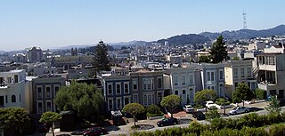
Berkeley is a city on the eastern shore of San Francisco Bay in northern Alameda County, California, United States. It is named after the 18th-century Anglo-Irish bishop and philosopher George Berkeley. It borders the cities of Oakland and Emeryville to the south and the city of Albany and the unincorporated community of Kensington to the north. Its eastern border with Contra Costa County generally follows the ridge of the Berkeley Hills. The 2020 census recorded a population of 124,321.

The University of California, Berkeley is a public land-grant research university in Berkeley, California. Founded in 1868 and named after the Anglo-Irish philosopher George Berkeley, it is the state's first land-grant university and is the founding campus of the University of California system.

Bernard Ralph Maybeck was an American architect in the Arts and Crafts Movement of the early 20th century. He worked primarily in the San Francisco Bay Area, designing public buildings, including the Palace of Fine Arts in San Francisco, and also private houses, especially in Berkeley, where he lived and taught at the University of California. A number of his works are listed on the National Register of Historic Places.
The Western Addition is a district in San Francisco, California, United States.

The Sigma Phi Society (ΣΦ) is the second Greek fraternal organization founded in the United States and the first to establish a chapter at another college, making it the first national Greek organization.

Donner Memorial State Park is a state park of California, US, preserving the site of the Donner Camp, where members of the ill-fated Donner Party were trapped by weather during the winter of 1846–1847. Caught without shelter or adequate supplies, members of the group resorted to cannibalism to survive. The Sierra Nevada site has been designated a National Historic Landmark. The state park contains the Emigrant Trail Museum and the Pioneer Monument dedicated to the travelers of the Emigrant Trail.

A California Historical Landmark (CHL) is a building, structure, site, or place in the U.S. state of California that has been determined to have statewide historical landmark significance.

The Berkeley School of Theology (BST) is a Baptist theological institute in Berkeley, California, U.S.. It is affiliated with the American Baptist Churches USA. It is part of the Graduate Theological Union, a consortium of theological schools and centers in the Berkeley area.
The William Randolph Hearst Greek Theatre, known locally as simply the Greek Theatre, is an 8,500-seat Greek Theatre owned and operated by the University of California, Berkeley in Berkeley, California, United States.

Garlock is an unincorporated community in Kern County, California, United States. It is located 6.25 miles (10 km) east-southeast of Saltdale, at an elevation of 2,169 feet.

Marshall Gold Discovery State Historic Park is a state park of California, United States, marking the discovery of gold by James W. Marshall at Sutter's Mill in 1848, sparking the California Gold Rush. The park grounds include much of the historic town of Coloma, California, which is now considered a ghost town as well as a National Historic Landmark District. The park contains the California Historical Landmarks: a monument to commemorate James Marshall (#143), the actual spot where he first discovered gold in 1848 (#530). Established in 1942, and Coloma Road (#748),. The park now comprises 576 acres (233 ha) in El Dorado County.

Hillside Elementary School is a 50,302 ft2 former public elementary school in the hills of Berkeley, California, at 1581 Le Roy Avenue, bordered by Le Roy Avenue, Buena Vista Way, and La Loma Avenue. It is registered as a local historic landmark and is listed on the National Register of Historic Places.

Havilah was an unincorporated community in Kern County, California that was completely leveled by the 2024 Borel Fire. The land is located in the mountains between Walker Basin and the Kern River Valley, 5 miles (8.0 km) south-southwest of Bodfish at an elevation of 3,136 feet (956 m).

The Studio Building is a historic building, listed on the National Register of Historic Places, and located at 2045 Shattuck Avenue, Berkeley, California.
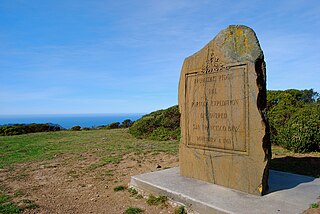
The San Francisco Bay Discovery Site is a marker commemorating the first recorded European sighting of San Francisco Bay. In 1769, the Portola expedition traveled north by land from San Diego, seeking to establish a base at the Port of Monterey described by Sebastian Vizcaino in 1602. When they reached Monterey, however, they were not sure it was the right place and decided to continue north. The party reached San Pedro Creek on October 31 and camped there for four nights, while scouts led by José Francisco Ortega climbed Sweeney Ridge, where they could see over the ridge toward the east, and so became the first Europeans to see San Francisco Bay on November 1.

This is a list of the National Register of Historic Places listings in Alameda County, California.

The College Women's Club was a women's club founded in 1920 based in Berkeley, California. It organized Berkeley's first cooperative day nursery and established scholarships.

Boone's University School is a historic building at 2029 Durant Avenue in Berkeley, California, U.S. It is the last surviving building from the Boone's University School for Boys, which closed in 1915. It is listed on the National Register of Historic Places since November 1, 1982; listed as a California Historical Landmark since November 1, 1982; and listed as a Berkeley Landmark since March 16, 1981.

Hilgard Hall is a historical building in Berkeley, California. The Hilgard Hall was built in 1917. The building and it site was listed on the National Register of Historic Places on March 25, 1982. Hilgard Hall is named for pedologist, Eugene W. Hilgard. Hilgard was the first dean of the University of California College of Agriculture from 1874 to 1904 at the University of California Berkeley. Eugene Hilgard also founded the University Agricultural Experimental Station. Hilgard Hall was designed by John Galen Howard in a Neo-classical design and Northern Italian Renaissance style. The Agricultural Complex has three buildings, Hilgard Hall, Wellman Hall, and Giannini Hall.


