Francis Farm Petroglyphs

Last updated

Francis Farm Petroglyphs Site (36FA35)
Perry Road toward ridgeline.jpg
Overview of the site
USA Pennsylvania location map.svg
Red pog.svg
Usa edcp location map.svg
Red pog.svg
LocationOff Perry Road in Jefferson Township, Fayette County, Pennsylvania, 1 mile (1.6 km) west of the junction of Pennsylvania Routes 51 and 201 [1] :115
Nearest city Perryopolis
Coordinates 40°3′0″N79°47′30″W / 40.05000°N 79.79167°W / 40.05000; -79.79167
Area0.1 acres (0.040 ha)
NRHP reference No. 84003370 [2]
Added to NRHPMay 10, 1984

The Francis Farm Petroglyphs are a group of petroglyphs in the southwestern part of the U.S. state of Pennsylvania. Located on a boulder in Jefferson Township in the northwestern portion of Fayette County, it has been known to archaeologists since at least the middle of the nineteenth century. Despite damage in the 1930s, it remains an important archaeological site, and accordingly, it has been designated a historic site.

Contents

Creation

Although it is certain that the Francis Farm site was produced by Native Americans, a more precise identification is believed to be impossible. Archaeologists have proposed that the creators were such peoples as the Monongahela or the ancestors of the Shawnee, both of whom are known to have inhabited southwestern Pennsylvania during the latter portions of the Woodland period. [3] :3

Geology

The petroglyph site is located on a large outcrop in Jefferson Township, approximately 2.6 miles (4.2 km) west of Perryopolis and 5.2 miles (8.4 km) north of Brownsville; its elevation is 1,140 feet (350 m). This outcrop is a roughly rectangular piece of Dunkard-series sandstone, measuring 6.3 metres (21 ft) from north to south and 5.7 metres (19 ft) from east to west. Its upper surface, upon which the petroglyphs are carven, slants toward the ground; the western end rises 3.2 metres (10 ft) above the surface, while the eastern edge is level with the surface of the ground. Several similar boulders lie in the petroglyph's immediate vicinity, although none feature Native American petroglyphs. [1] :51 The site lies in the middle of woodlands; trees and brush grow up to the stone's edge. [1] :Plate 56

Petroglyphs

Six different outcrops on the Francis Farm have been used for the creation of petroglyphs, although only one today bears Native American carvings. One other boulder, located to the east of the primary stone, once bore similar Native American carvings, however, local residents have reported that it was destroyed in the 1930s, while the surrounding land was being quarried for the construction of a road. Incisions on the other four stones remain in fine condition; however, they are clearly modern works, for among their inscriptions are various Latin letters and depictions of firearms. [1] :51

At least sixteen different carvings are present on the primary outcrop, [1] :51 divided into seven different categories: artifacts, geometric figures, the human body, mammals, reptiles, a shape resembling the letter "W," and various small pits. Some of the carvings include multiple parts; for example, design 13 is composed of seven small pits, also known as "nut-cracker holes". The most common subject is the human body; designs 2 and 10 depict a complete human form, while designs 1 and 15 are images of human heads. [1] :53 Other images include what is believed to be the mythological "spirit otter" (design 5), a four-footed animal (design 6), and a rattlesnake (design 11). [1] :52 What has been called the letter "W", which also has been found at other petroglyph sites, may be an abstract form; archaeologist James L. Swauger called it a "W" for the sake of simplicity. A small number of carvings, such as arrows and hook-like shapes, are believed to be the work of recent vandals. [1] :53

The presence of amorphous shapes among the carvings is typical of Native American petroglyphs. Although their meanings are not known, their resemblance to shapes found at similar sites elsewhere in the upper Ohio River valley indicates that many of these sites were produced by the same, or similar cultures. Other designs common to these petroglyphs include the shapes and the footprints of birds, humans, and other mammals. [3] :3

Recognition

The Francis Farm Petroglyphs have been known since at least the middle of the nineteenth century. Written in 1843, Sherman Day's Historical Collections of the State of Pennsylvania makes reference to the site, as do authors from 1893, 1930, and 1934. Carnegie Museum of Natural History archaeologist James Swauger officially documented the site in late 1958. Despite this widespread documentation, the site has remained remarkably free from damage; natural processes have eroded it somewhat, [3] :2 and Swauger was unable to find certain elements documented by previous surveys, [1] :53 but these aspects are exceptions: almost all designs present in early renditions of the site remain easily distinguished today. [3] :2

At the time of the European settlement of southwestern Pennsylvania, several petroglyphs were present within Fayette County's present boundaries. Among the sites that survived into modern times were ones known as the New Geneva Petroglyphs, the Petroglyphs Opposite Millsboro, and the Dunn Farm Petroglyphs. [1] :53,63,66 Many sites in the upper Ohio River valley, including several in Fayette County, were destroyed in the late twentieth century, making the Francis Farm site extremely valuable for future students of Native American petroglyphy. [3] :3 Because of their archaeological value, the Francis Farm Petroglyphs were listed on the National Register of Historic Places in 1984. [2]

See also

Related Research Articles

<span class="mw-page-title-main">Jefferson Township, Fayette County, Pennsylvania</span> Township in Pennsylvania, United States

Jefferson Township is a township in Fayette County, Pennsylvania, United States. The population was 2,008 at the 2020 census, a decline from the figure of 2,008 tabulated in 2010. It is named for former president Thomas Jefferson, and many of the township's streets are named after other U.S. presidents. Frazier School District serves the area.

<span class="mw-page-title-main">Jeffers Petroglyphs</span> United States historic place

The Jeffers Petroglyphs site is an outcrop in southwestern Minnesota with pre-contact Native American petroglyphs. The petroglyphs are pecked into rock of the Red Rock Ridge, a 23-mile (37 km)-long Sioux quartzite outcrop that extends from Watonwan County, Minnesota to Brown County, Minnesota. The exposed surface is approximately 150 by 650 feet and surrounded by virgin prairie. "The site lies in an area inhabited in the early historic period by the Dakota Indians, and both the style and form of some of the carvings are identical with motifs that appear on Dakota hide paintings and their quill designs and beadwork. Others are foreign to this Plains Indian tradition and seem to be much earlier in origin." Several old wagon trail ruts traverse the site, one of which is believed to be the old stage coach route from New Ulm, Minnesota to Sioux Falls, South Dakota.

<span class="mw-page-title-main">Sanilac Petroglyphs Historic State Park</span> Park in Michigan, USA

Sanilac Petroglyphs Historic State Park is a state park in the U.S. state of Michigan. The park, also known as ezhibiigadek asin consists of 240 acres (97 ha) in Greenleaf Township, Sanilac County, in Michigan's Thumb. It contains the largest collection of Native American petroglyphs in Michigan. The carvings were created in the pre-Columbian era and represent aspects of Native American spirituality. An interpretive hiking trail within the park passes along the nearby Cass River.

<span class="mw-page-title-main">Washington State Park</span>

Washington State Park is a public recreation area covering 2,147 acres (869 ha) in Washington County in the central eastern part of the state of Missouri. It is located on Highway 21 about 14 miles (23 km) northeast of Potosi or 7 miles (11 km) southwest of DeSoto on the eastern edge of the Ozarks. The state park is noted for its Native American rock carvings and for its finely crafted stonework from the 1930s.

<span class="mw-page-title-main">Track Rock</span>

Track Rock is located in the Track Rock Gap Archaeological Area (9Un367) in the Brasstown Ranger District of the Chattahoochee National Forest in Georgia. This 52-acre (210,000 m2) area contains preserved petroglyphs of ancient Native American origin that resemble animal and bird tracks, crosses, circles and human footprints.

American Indian Rock Art in Minnesota MPS is a Multiple Property Submission (MPS) of the eligibility of many rock art properties for listing on the National Register of Historic Places. The listing is to protect and preserve Native American petroglyphs, pictographs and petroform rock art sites in the present day U.S. state of Minnesota.

<span class="mw-page-title-main">Greaser Petroglyph Site</span> United States historic place

The Greaser Petroglyph Site is located on land managed by the Bureau of Land Management in eastern Lake County, Oregon. The designs were scraped into a basalt boulder by Native Americans perhaps 12,000 years ago. No one knows the meaning of the designs. Because of its unique archaeological and cultural significance, the Greaser Petroglyph Site was listed on the National Register of Historic Places in 1974.

<span class="mw-page-title-main">Painted Rock Petroglyph Site</span> Archaeological site in Arizona, United States

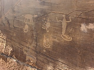
The Painted Rock Petroglyph Site is a collection of hundreds of ancient petroglyphs near the town of Theba, Arizona, United States, listed on the National Register of Historic Places in 1977. The site is operated and maintained by the Bureau of Land Management (BLM), and includes an improved campground as well as an informative walking trail showcasing the petroglyphs.

<span class="mw-page-title-main">Barnesville Petroglyph</span> Archaeological site in Ohio, United States

The Barnesville Petroglyph petroglyph site in the eastern part of the U.S. state of Ohio. Located approximately 3 miles (4.8 km) southwest of the village of Barnesville in Belmont County, the petroglyphs have been known both by archaeologists and the general public since the 1850s or earlier. Although the site was significantly damaged during the twentieth century, it is still a significant archaeological site, and has been named a historic site.

<span class="mw-page-title-main">Indian God Rock</span> United States historic place

Indian God Rock is a large boulder in the northwestern part of the U.S. state of Pennsylvania. Located near the unincorporated community of Brandon, it lies along the Allegheny River in Venango County's Rockland Township. It is significant for the large petroglyph on one of its sides. Because of the petroglyph, the rock has been an explorers' landmark, a tourist attraction, and an object of scholarly investigation.

<span class="mw-page-title-main">James L. Swauger</span> American archaeologist (1913–2005)

James L. Swauger was an American archaeologist known for his work on the petroglyphs of the Ohio River valley of the United States. A native of West Newton in Westmoreland County, Pennsylvania, he moved to the Pittsburgh suburb of Edgewood in his youth; there he lived for most of the rest of his life.

<span class="mw-page-title-main">Sugar Grove Petroglyphs</span> United States historic place

The Sugar Grove Petroglyphs are a group of petroglyphs in the southwestern part of the U.S. state of Pennsylvania. Located on an outcrop of sandstone in Monongahela Township near the eastern edge of Greene County, the petroglyphs have been known since at least the 1930s. Due to their value as an archaeological site, the petroglyphs have been named a historic site.

<span class="mw-page-title-main">Petroglyph Beach State Historic Park</span> State park in Alaska, United States

Indian Cave Petroglyphs is a historic archaeological site located near Good Hope, Harrison County, West Virginia. It consists of petroglyphs occupying an area of 20 feet by 4 feet on the back wall of a rockshelter. These artifacts were first reported by archaeologist William Henry Holmes (1846-1933) of the Bureau of American Ethnology who visited the area in 1889. He also found pottery that indicates an occupation or occupations between 500 and 1675.

Hamilton Farm Petroglyphs, also known as Pictured Rocks and Indian Picture Rocks, are a series of ancient petroglyphs located on U.S. Route 119 southeast of Ringgold, in Monongalia County of northern West Virginia. The rock art designs were carved by early Native Americans on sandstone.

<span class="mw-page-title-main">Judaculla Rock</span> United States historic place

Judaculla Rock is a curvilinear-shaped outcrop of soapstone known for its ancient carvings and petroglyphs. The archaeological site is located on a 0.85-acre rectangular-shaped property, now owned by Jackson County. It is approximately 60 meters east of Caney Fork Creek, a major branch of the northwestward-trending Tuckasegee River in the mountains of Western North Carolina.

<span class="mw-page-title-main">Petroglyph Canyon</span> United States historic place

Petroglyph Canyon (24CB601) is an archaeologically significant canyon in the northwestern United States. Located on both sides of the border between Montana and Wyoming, the canyon has long been obscure due to its small size. However, it gained substantial attention in the late 20th century because of its numerous prehistoric petroglyphs, and much of it was named a historic site in the 1970s.

<span class="mw-page-title-main">Picture Rock Pass Petroglyphs Site</span> United States historic place

The Picture Rock Pass Petroglyphs Site is in northern Lake County, Oregon, United States. The site is located near the summit of Picture Rock Pass on land administered by the Bureau of Land Management. The designs were scraped into a basalt boulder by ancient Native Americans, probably between 7,500 and 12,000 years ago. No one knows the meaning of the petroglyph designs. Because of its unique archaeological and cultural significance, the Picture Rock Pass Petroglyph Site was listed on the National Register of Historic Places in 1975.

<span class="mw-page-title-main">Tainter Cave</span> United States historic place

Tainter Cave, also known as Tombstone Cave, is a dry sandstone cave in Crawford County, Wisconsin, in which prehistoric Native Americans carved petroglyphs and drew pictographs, including birds, men, deer, and abstract designs. With over 100 pictographs, the cave holds more than any other known site in Wisconsin. It is also notable as the first archaeological site recorded in the dark zone of a cave in the Upper Midwest.

References

  1. 1 2 3 4 5 6 7 8 9 10 Swauger, James L. Rock Art of the Upper Ohio Valley. Graz: Akademische Druck- und Verlagsanstalt, 1974.
  2. 1 2 "National Register Information System". National Register of Historic Places . National Park Service. March 13, 2009.
  3. 1 2 3 4 5 Herbstritt, James T. National Register of Historic Places Inventory/Nomination: Francis Farm Petroglyphs Site (36FA35). National Park Service, 1980-07-22.

Further reading