
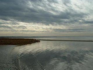
Cape Cod is a peninsula extending into the Atlantic Ocean from the southeastern corner of Massachusetts, in the northeastern United States. Its historic, maritime character and ample beaches attract heavy tourism during the summer months. The name Cape Cod, coined in 1602 by Bartholomew Gosnold, is the ninth oldest English place-name in the U.S.

Barnstable County is a county located in the U.S. state of Massachusetts. At the 2020 census, the population was 228,996. Its county seat is Barnstable. The county consists of Cape Cod and associated islands.
Eastham is a town in Barnstable County, Massachusetts, United States, Barnstable County being coextensive with Cape Cod. The population was 5,752 at the 2020 census.

Brewster is a town in Barnstable County, Massachusetts, United States, Barnstable County being coextensive with Cape Cod. The population of Brewster was 10,318 at the 2020 census.

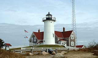
Chatham is a town in Barnstable County, Massachusetts, United States. Chatham is located at the southeastern tip of Cape Cod and has historically been a fishing community. First settled by the English in 1664, the township was originally called Monomoit based on the indigenous population's term for the region. Chatham was incorporated as a town on June 11, 1712, and has become a summer resort area. The population was 6,594 at the 2020 census, and can swell to 25,000 during the summer months. There are four villages that comprise the town, those being Chatham (CDP), South Chatham, North Chatham, and West Chatham. Chatham is home to the Monomoy National Wildlife Refuge, and the decommissioned Monomoy Point Light both located on Monomoy Island. A popular attraction is the Chatham Light, which is an operational lighthouse that is operated by the United States Coast Guard.
Falmouth is a town in Barnstable County, Massachusetts, United States. The population was 32,517 at the 2020 census, making Falmouth the second-largest municipality on Cape Cod after Barnstable. The terminal for the Steamship Authority ferries to Martha's Vineyard is located in the village of Woods Hole in Falmouth. Woods Hole also contains several scientific organizations such as the Woods Hole Oceanographic Institution (WHOI), the Marine Biological Laboratory (MBL), the Woodwell Climate Research Center, NOAA's Woods Hole Science Aquarium, and the scientific institutions' various museums.

Orleans is a town in Barnstable County, Massachusetts, United States, situated along Cape Cod. The population was 6,307 at the 2020 census.

Hyannis is the largest of the seven villages in the town of Barnstable, Massachusetts, United States. It is the commercial and transportation hub of Cape Cod and was designated an urban area at the 1990 census. Because of this, many refer to Hyannis as the "Capital of the Cape". It contains a majority of the Barnstable Town offices and two important shopping districts: the historic downtown Main Street and the Route 132 Commercial District, including Cape Cod Mall and Independence Park, headquarters of Cape Cod Potato Chips. Cape Cod Hospital in Hyannis is the largest on Cape Cod.

Cotuit is one of the villages of the Town of Barnstable on Cape Cod in Barnstable County, Massachusetts, United States. Located on a peninsula on the south side of Barnstable about midway between Falmouth and Hyannis, Cotuit is bounded by the Santuit River to the west on the Mashpee town line, the villages of Marstons Mills to the north and Osterville to the east, and Nantucket Sound to the south. Cotuit is primarily residential with several small beaches including Ropes Beach, Riley's Beach, The Loop Beach and Oregon Beach.

The Cape Cod Baseball League is a collegiate summer baseball wooden bat league located on Cape Cod in the U.S. state of Massachusetts. One of the nation's premier collegiate summer leagues, the league boasts over one thousand former players who have gone on to play in the major leagues.

Massachusetts Route 6A is the state road for two sections formerly known as U.S. Route 6 (US 6) on Cape Cod. Most of Route 6A is also known as the Old King's Highway. Combining the 2 major sections, the highway is approximately 62 miles (100 km) long.

The Cape Cod Rail Trail (CCRT) is a 25.5-mile (41.0 km) paved rail trail located on Cape Cod in Massachusetts. The trail route passes through the towns of Yarmouth, Dennis, Harwich, Brewster, Orleans, Eastham, and Wellfleet. It connects to the 6-plus mile (10 km) Old Colony Rail Trail leading to Chatham, the 2 mile Yarmouth multi-use trail, and 8 miles (13 km) of trails within Nickerson State Park. Short side trips on roads lead to national seashore beaches including Coast Guard Beach at the end of the Nauset Bike Trail in Cape Cod National Seashore. The trail is part of the Claire Saltonstall Bikeway.

The Highland Light is an active lighthouse on the Cape Cod National Seashore in North Truro, Massachusetts. The current tower was erected in 1857, replacing two earlier towers that had been built in 1797 and 1831. It is the oldest and tallest lighthouse on Cape Cod.
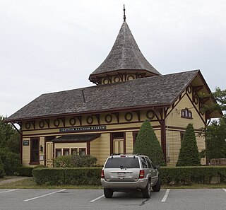
Chatham station is a former railroad station located on Depot Road in Chatham, Massachusetts. In use from 1887 to 1937, it has housed the Chatham Railroad Museum since 1960. The station was listed on the National Register of Historic Places in 1978 as Chatham Railroad Depot.

The Atwood–Higgins Historic District encompasses a historic property with deep colonial roots in Cape Cod National Seashore. Located on Bound Brook Island on the west side of Wellfleet, Massachusetts, the centerpiece of the district is the Thomas Atwood House, built c. 1730. The property is emblematic of Cape Cod's colonial origins and its later transformation into a summer resort area. The house was listed on the National Register of Historic Places in 1976; the district was listed in 2010. The property is open for guided tours by the National Park Service on a seasonal basis.
The French Cable Hut is a historic building in Cape Cod National Seashore, near the Nauset Beach Light in Eastham, Massachusetts. Built in 1891, the hut formed a linkage point in the transatlantic telegraph cable of the French Cable Company connecting the cable, where it came ashore near the present site to its main station in Orleans. After the cable was abandoned in 1932, the hut was adapted for residential use. It has since been restored to its turn-of-the-century appearance by the National Park Service. The building was listed on the National Register of Historic Places in 1976.

The Marconi–RCA Wireless Receiving Station is a historic district at the junction of Old Comers Rd. and Orleans Rd. in Chatham, Massachusetts. It and its companion transmitter station at Marion were used for WCC, the busiest ship to shore radio station for most of the 20th century. The district includes eight red brick buildings constructed by Marconi in 1914 to house the station's operations; it was listed on the National Register of Historic Places in 1994, and is now home to the Chatham Marconi Maritime Center museum.

Monomoy Point Light is a historic light in Chatham, Massachusetts.

Barnstable is a town in the U.S. state of Massachusetts and the county seat of Barnstable County. Barnstable is the largest community, both in land area and population, on Cape Cod, and is one of thirteen Massachusetts municipalities that have been granted city forms of government by the Commonwealth of Massachusetts but wish to retain "the town of" in their official names. At the 2020 census it had a population of 48,916. The town contains several villages within its boundaries. Its largest village, Hyannis, is the central business district of the county and home to Barnstable Municipal Airport, the airline hub of Cape Cod and the islands of Martha's Vineyard and Nantucket. Additionally, Barnstable is a 2007 winner of the All-America City Award.

The Truro Highlands Historic District encompasses an area of North Truro, Massachusetts, within the Cape Cod National Seashore, that has served as a recreational destination for more than 175 years. The major features of the district, which is centered on Highland Road east of US Route 6, are the Highland Light Station, the Highland House, and the Highland Golf Links, one of the oldest golf courses on Cape Cod.


