Friendship, Tennessee

Last updated

Friendship, Tennessee
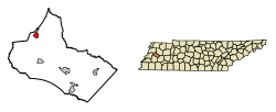
Crockett County Tennessee Incorporated and Unincorporated areas Friendship Highlighted 4727960.svg
Location of Friendship in Crockett County, Tennessee.
Coordinates: 35°54′37″N89°14′31″W / 35.91028°N 89.24194°W / 35.91028; -89.24194
Country United States
State Tennessee
County Crockett
First Settled1820's
Incorporated1859
Government
  MayorCasey Burnett
Area
[1]
  Total1.32 sq mi (3.42 km2)
  Land1.32 sq mi (3.42 km2)
  Water0.00 sq mi (0.00 km2)
Elevation
400 ft (122 m)
Population
 (2020) [2]
  Total613
  Density464.75/sq mi (179.49/km2)
Time zone UTC-6 (Central (CST))
  Summer (DST) UTC-5 (CDT)
ZIP code
38034
Area code 731
FIPS code 47-27960 [3]
GNIS feature ID1284921 [4]

Friendship is a city in Crockett County, Tennessee. The population was 668 at the 2010 census.

Contents

History

The city of Friendship was founded in 1853, though there was a post office in operation in the area as early as 1844. The city was plotted out in 1858, and incorporated the following year with W.P. Rice serving as the first mayor. [5]

According to local lore, when the post office was established in 1884, there were two major stores that were doing business in the area, each about a mile from the site of the post office. By mutual consent, they split the distance and moved their stores to the site of today's downtown. This act of friendship inspired the town's name. [6]

By the 1920's the Birmingham and Northwestern Railroad had laid track on the east side of town and constructed a depot. [7]

Geography

Friendship is located at 35°54′37″N89°14′31″W / 35.91028°N 89.24194°W / 35.91028; -89.24194 (35.910370, -89.241827). [8]

According to the United States Census Bureau, the city has a total area of 1.3 square miles (3.4 km2), all land.

Demographics

Historical population
CensusPop.Note
1880 243
1890 2554.9%
1920 487
1930 4870.0%
1940 451−7.4%
1950 4520.2%
1960 399−11.7%
1970 44110.5%
1980 76373.0%
1990 467−38.8%
2000 60830.2%
2010 6689.9%
2020 613−8.2%
Sources: [9] [10] [2]

As of the census [3] of 2000, there were 608 people, 246 households, and 171 families residing in the city. The population density was 466.4 inhabitants per square mile (180.1/km2). There were 264 housing units at an average density of 202.5 per square mile (78.2/km2). The racial makeup of the city was 85.36% White, 11.68% African American, 0.33% Native American, 2.14% from other races, and 0.49% from two or more races. Hispanic or Latino of any race were 3.45% of the population.

There were 246 households, out of which 32.5% had children under the age of 18 living with them, 49.6% were married couples living together, 15.9% had a female householder with no husband present, and 30.1% were non-families. 28.0% of all households were made up of individuals, and 10.2% had someone living alone who was 65 years of age or older. The average household size was 2.47 and the average family size was 2.97.

In the city, the population was spread out, with 26.5% under the age of 18, 9.7% from 18 to 24, 27.0% from 25 to 44, 20.7% from 45 to 64, and 16.1% who were 65 years of age or older. The median age was 38 years. For every 100 females, there were 91.8 males. For every 100 females age 18 and over, there were 93.5 males.

The median income for a household in the city was $24,583, and the median income for a family was $35,909. Males had a median income of $29,375 versus $19,792 for females. The per capita income for the city was $14,641. About 16.1% of families and 23.0% of the population were below the poverty line, including 26.2% of those under age 18 and 27.5% of those age 65 or over.
Education

Notable people

Related Research Articles

<span class="mw-page-title-main">Crockett County, Tennessee</span> County in Tennessee, United States

Crockett County is located in the U.S. state of Tennessee. As of the 2020 census, the population was 13,911. Its county seat is Alamo. Crockett County is included in the Jackson, TN Metropolitan Statistical Area.

<span class="mw-page-title-main">East Hope, Idaho</span> City in Idaho, United States

East Hope is a city in Bonner County, Idaho, United States. The population was 210 at the 2010 census.

<span class="mw-page-title-main">Alamo, Tennessee</span> Town in Tennessee, United States

Alamo is a town in Crockett County, Tennessee, United States. Its population was 2,461 at the time of the 2010 U.S. Census. Alamo, located in the central part of West Tennessee, is the county seat of Crockett County.

<span class="mw-page-title-main">Bells, Tennessee</span> City in Tennessee, United States

Bells is a city in Crockett County, Tennessee. The population was 2,437 at the 2010 census.

<span class="mw-page-title-main">Gadsden, Tennessee</span> Town in Tennessee, United States

Gadsden is a town in Crockett County, Tennessee, United States. The population was 470 at the 2010 census. It is the birthplace of Hall of Fame rock guitarist Scotty Moore, who played with Elvis Presley and Ricky Nelson.

<span class="mw-page-title-main">Maury City, Tennessee</span> Town in Tennessee, United States

Maury City is a town in Crockett County, Tennessee. The population was 674 at the 2010 census. Locals pronounce the town's name as "Murray City."

<span class="mw-page-title-main">Braden, Tennessee</span> Town in Tennessee, United States

Braden is a town in Fayette County, Tennessee. The population was 282 at the 2010 census. The town is named after Joseph P. Braden.

<span class="mw-page-title-main">Moscow, Tennessee</span> City in Tennessee, United States

Moscow is a city in Fayette County, Tennessee, United States. The population was 568 at the 2020 census, 556 at the 2010 census, and 422 at the 2000 census. The town was named after a Cherokee Chief [Mosgo], meaning "Town between 2 rivers." North Fork and Wolf Rivers.

<span class="mw-page-title-main">Piperton, Tennessee</span> City in Tennessee, United States

Piperton is a city in Fayette County, Tennessee, United States. The population was 2,263 at the 2020 census. In 2007 USA Today cited the National Motorist Association when it listed Piperton as one of the worst cities for speeding tickets across the USA.

<span class="mw-page-title-main">Rossville, Tennessee</span> Town in Tennessee, United States

Rossville is a town in Fayette County, Tennessee, United States. The population was 1,041 at the 2020 census, up from 664 at the 2010 census.

<span class="mw-page-title-main">Williston, Tennessee</span> City in Tennessee, United States

Williston is a city in Fayette County, Tennessee, United States. The population was 395 at the 2010 census.

<span class="mw-page-title-main">Bolivar, Tennessee</span> City in Tennessee, United States

Bolivar is a city in and the county seat of Hardeman County, Tennessee, United States. The town was named for South American revolutionary leader Simón Bolívar. As of the 2010 census, the city population was 5,417.

<span class="mw-page-title-main">Lawrenceburg, Tennessee</span> City in Tennessee, United States

The city of Lawrenceburg is the county seat of Lawrence County, Tennessee, United States, The largest city on the state's southern border between Chattanooga and Memphis, it lies on the banks of Shoal Creek. The population was 11,633 at the 2020 United States Census. The city is named after War of 1812 American Navy officer James Lawrence.

<span class="mw-page-title-main">Troy, Tennessee</span> Town in Tennessee, United States

Troy is a town in Obion County, Tennessee, United States. The population was 1,423 at the 2020 census. It is part of the Union City, TN–KY Micropolitan Statistical Area.

<span class="mw-page-title-main">Lobelville, Tennessee</span> City in Tennessee, United States

Lobelville is a city in Perry County, Tennessee, United States that was established as a trading post on the Buffalo River in 1854. The population was 897 at the 2010 census.

<span class="mw-page-title-main">Lakeland, Tennessee</span> City in Tennessee, United States

Lakeland is a city in Shelby County, Tennessee, United States, and a part of the Memphis metropolitan area. The population was 12,430 at the 2010 census.

Gilt Edge is a city in Tipton County, Tennessee. The population was 477 at the 2010 census and 456 in 2018, showing a decrease of 21.

<span class="mw-page-title-main">Mason, Tennessee</span> Town in Tennessee, United States

Mason is a town in Tipton County, Tennessee. The population was 1,609 at the 2010 census. Mason is located along U.S. Route 70, and is home to a federal detention facility.

<span class="mw-page-title-main">Matoaka, West Virginia</span> Census-designated place in West Virginia, United States

Matoaka is a census-designated place in Mercer County, West Virginia, United States. The population was 173 at the 2020 census. It is part of the Bluefield, WV-VA micropolitan area which has a population of 100,093. This town is named for Chief Powhatan's daughter Matoaka who was better known by her nickname "Pocahontas". Matoaka became an unincorporated town when it voted to dissolve its charter in May 2018.

<span class="mw-page-title-main">White House, Tennessee</span> City in Tennessee, United States

White House is a city in Robertson and Sumner counties in the United States state of Tennessee. The population was listed as 12,982 in the 2020 census. It is approximately twenty-two miles north of downtown Nashville.

References

  1. "ArcGIS REST Services Directory". United States Census Bureau. Retrieved October 15, 2022.
  2. 1 2 "Census Population API". United States Census Bureau. Retrieved October 15, 2022.
  3. 1 2 "U.S. Census website". United States Census Bureau . Retrieved January 31, 2008.
  4. "US Board on Geographic Names". United States Geological Survey. October 25, 2007. Retrieved January 31, 2008.
  5. History of Tennessee from the earliest time to the present, together with an historical and biographical sketch of Lauderdale, Tipton, Haywood, and Crockett Counties. Nashville: Goodspeed publishing co. 1887.
  6. "Community History". Crockett County Chamber of Commerce. Retrieved January 25, 2024.
  7. Strouse, L.K. (1925). Interstate Commerce Commission Reports: Reports and Decisions of the Interstate Commerce Commission of the United States. Vol. 84.
  8. "US Gazetteer files: 2010, 2000, and 1990". United States Census Bureau. February 12, 2011. Retrieved April 23, 2011.
  9. "Census of Population and Housing: Decennial Censuses". United States Census Bureau . Retrieved March 4, 2012.
  10. "Incorporated Places and Minor Civil Divisions Datasets: Subcounty Resident Population Estimates: April 1, 2010 to July 1, 2012". Population Estimates. U.S. Census Bureau. Archived from the original on June 11, 2013. Retrieved December 11, 2013.