Gairloch, Queensland

Last updated

Gairloch
Queensland
Old Gairloch Bridge, 2024 03.jpg
Old Gairloch Bridge, 2024
Australia Queensland location map.svg
Red pog.svg
Gairloch
Coordinates 18°36′07″S146°10′41″E / 18.6019°S 146.1780°E / -18.6019; 146.1780 (Gairloch (centre of locality))
Population31 (2021 census) [1]
 • Density2.31/km2 (5.99/sq mi)
Postcode(s) 4850
Area13.4 km2 (5.2 sq mi)
Time zone AEST (UTC+10:00)
Location
LGA(s) Shire of Hinchinbrook
State electorate(s) Hinchinbrook
Federal division(s) Kennedy
Suburbs around Gairloch:
Bemerside Bemerside Bemerside
Hawkins Creek Gairloch Foresthome
Hawkins Creek Ingham Foresthome

Gairloch is a rural locality in the Shire of Hinchinbrook, Queensland, Australia. [2] In the 2021 census, Gairloch had a population of 31 people. [1]

Contents

Geography

The locality is bounded by the Herbert River to the east and by Ripple Creek, a tributary of the Herbert River, to the north. [3]

The Bruce Highway enters the locality from the south (Ingham) crossing the river on the Sir John Row Bridge into Gairloch. The highway exits to the north to the locality (Bemerside). [4]

The predominant land use is growing sugarcane. [5] There is a network of cane tramways to transport the harvested sugarcane to the local sugar mill. [4]

History

Historically, Gairloch was south of the Herbert River where the now-abandoned Gairloch railway station was located ( 18°37′41″S146°10′53″E / 18.628181°S 146.1814685°E / -18.628181; 146.1814685 (Gairloch railway station (former)) ). [6] The land to the north of the Herbert River was known as North Gairloch. Gairloch and North Garloch were connected via the Garloch Bridge ( 18°37′00″S146°10′59″E / 18.61663°S 146.18307°E / -18.61663; 146.18307 (Gairloch Bridge) ). [7] Today, the northern side of the river is known simply as Gairloch and the land known as Gairloch on the southern side of the river is now within the localities of Ingham and Foresthome. The former Gairloch railway station is now within Foresthome. [8]

In October 1921, the Queensland Government approved the construction of the North Gairloch State School at a cost of £869. The school opened in July 1922. [9] [10] In October 1936, tenders were called to build a teacher's residence. [11] The school closed circa 1942. [12] The school was on the north-western side of Hawkins Creek Road (approx 18°37′33″S146°09′31″E / 18.62575°S 146.15848°E / -18.62575; 146.15848 (North Gairloch State School (former)) ). [13] [14]

In January 1955, a crocodile was sighted in the Herbert River near Gairloch. [15]

Demographics

In the 2016 census, Gairloch had a population of 41 people. [16]

In the 2021 census, Gairloch had a population of 31 people. [1]

Heritage listings

Ingham has a number of heritage-listed sites, including:

Education

There are no schools in Gairloch. The nearest government primary schools are Ingham State School in neighbouring Ingham to the south and Macknade State School in Macknade to the north-east. The nearest government secondary school is Ingham State High School, also in Ingham. There are also non-government primary and secondary schools in Ingham. [18]

Related Research Articles

<span class="mw-page-title-main">Ingham, Queensland</span> Town in Queensland, Australia

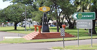
Ingham is a rural town and locality in the Shire of Hinchinbrook, Queensland, Australia. It is named after William Bairstow Ingham and is the administrative centre for the Shire of Hinchinbrook.

<span class="mw-page-title-main">Halifax, Queensland</span> Town in Queensland, Australia

Halifax is a town and a coastal locality in the Shire of Hinchinbrook, Queensland, Australia. In the 2021 census, the locality of Halifax had a population of 477 people.

<span class="mw-page-title-main">Abergowrie, Queensland</span> Town in Queensland, Australia

Abergowrie is a rural town and locality in the Shire of Hinchinbrook, Queensland, Australia. In the 2021 census, the locality of Abergowrie had a population of 305 people.

<span class="mw-page-title-main">Macknade, Queensland</span> Town in Queensland, Australia

Macknade is a rural town and coastal locality in the Shire of Hinchinbrook, Queensland, Australia. In the 2021 census, the locality of Macknade had a population of 203 people.

<span class="mw-page-title-main">Gairloch Bridge</span> Historic site in Queensland, Australia

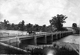
Gairloch Bridge is a heritage-listed road bridge on the Old Bruce Highway over the Herbert River between Foresthome and Gairloch, near Ingham in the Shire of Hinchinbrook, Queensland, Australia. It was designed by Alfred Barton Brady and built from 1890 to 1891 by James Graham. It was added to the Queensland Heritage Register on 17 July 2008.

Damper Creek is a coastal locality in the Cassowary Coast Region, Queensland, Australia. In the 2021 census, Damper Creek had a population of 34 people.

Victoria Plantation is a rural locality in the Shire of Hinchinbrook, Queensland, Australia. In the 2021 census, Victoria Plantation had a population of 169 people.

Bambaroo is a rural locality in the Shire of Hinchinbrook, Queensland, Australia. In the 2021 census, Bambaroo had a population of 146 people.

Helens Hill is a rural locality in the Shire of Hinchinbrook, Queensland, Australia. In the 2021 census, Helens Hill had a population of 118 people.

Foresthome is a rural locality in the Shire of Hinchinbrook, Queensland, Australia. In the 2021 census, Foresthome had a population of 84 people.

<span class="mw-page-title-main">Peacock Siding, Queensland</span> Suburb of Shire of Hinchinbrook, Queensland, Australia

Peacock Siding is a rural locality in the Shire of Hinchinbrook, Queensland, Australia. In the 2021 census, Peacock Siding had a population of 85 people.

<span class="mw-page-title-main">Bemerside, Queensland</span> Suburb of Shire of Hinchinbrook, Queensland, Australia

Bemerside is a rural locality in the Shire of Hinchinbrook, Queensland, Australia. In the 2021 census, Bemerside had a population of 259 people.

Yuruga is a rural locality in the Shire of Hinchinbrook, Queensland, Australia. In the 2021 census, Yuruga had a population of 64 people.

Rungoo is a coastal locality in the Cassowary Coast Region, Queensland, Australia. In the 2021 census, Rungoo had a population of 11 people.

<span class="mw-page-title-main">Hawkins Creek, Queensland</span> Suburb of Shire of Hinchinbrook, Queensland, Australia

Hawkins Creek is a rural locality in the Shire of Hinchinbrook, Queensland, Australia. In the 2021 census, Hawkins Creek had a population of 236 people.

Garrawalt is a rural locality in the Shire of Hinchinbrook, Queensland, Australia.

South Innisfail is a rural locality in the Cassowary Coast Region, Queensland, Australia. In the 2021 census, South Innisfail had a population of 508 people.

Warrubullen is a rural locality in the Cassowary Coast Region, Queensland, Australia. In the 2021 census, Warrubullen had a population of 59 people.

Daveson is a rural locality in the Cassowary Coast Region, Queensland, Australia. In the 2021 census, Daveson had a population of 33 people.

Friday Pocket is a rural locality in the Cassowary Coast Region, Queensland, Australia. In the 2021 census, Friday Pocket had a population of 39 people.

References

  1. 1 2 3 Australian Bureau of Statistics (28 June 2022). "Gairloch (SAL)". 2021 Census QuickStats. Retrieved 28 February 2023. OOjs UI icon edit-ltr-progressive.svg
  2. "Gairloch – locality in Shire of Hinchinbrook (entry 42516)". Queensland Place Names. Queensland Government . Retrieved 28 October 2019.
  3. "Layers: Locality; Mountains and ranges; Contours; Watercourses". Queensland Globe. Queensland Government . Retrieved 1 February 2025.
  4. 1 2 "Layers: Locality; Road and rail; Railways; Railway stations". Queensland Globe. Queensland Government . Retrieved 1 February 2025.
  5. "Layers: Locality; Protected areas and forests; Land use; Sugarcane areas". Queensland Globe. Queensland Government . Retrieved 1 February 2025.
  6. "Railway stations and sidings - Queensland". Queensland Open Data. Queensland Government. 2 October 2020. Archived from the original on 5 October 2020. Retrieved 5 October 2020.
  7. "Ingham" (Map). Queensland Government. 1943. Retrieved 1 February 2025.
  8. "Layers: Locality; Road and rail; Railways; Railway stations". Queensland Globe. Queensland Government . Retrieved 1 February 2025.
  9. "SCHOOLS EXPENDITURE". Daily Mercury . Vol. 56, no. 478. Queensland, Australia. 8 July 1922. p. 5. Retrieved 1 February 2025 via National Library of Australia.
  10. "PUBLIC WORKS". The Telegraph . No. 15258. Queensland, Australia. 22 October 1921. p. 10 (SECOND EDITION). Retrieved 1 February 2025 via National Library of Australia.
  11. "Advertising". Townsville Daily Bulletin . Vol. LVIII, no. 236. Queensland, Australia. 1 October 1936. p. 2. Retrieved 1 February 2025 via National Library of Australia.
  12. Queensland Family History Society (2010), Queensland schools past and present (Version 1.01 ed.), Queensland Family History Society, ISBN   978-1-921171-26-0
  13. "Queensland Two Mile series sheet 2m379" (Map). Queensland Government. 1940. Retrieved 1 February 2025.
  14. "Queensland Two Mile series sheet 2m379" (Map). Queensland Government. 1950. Retrieved 1 February 2025.
  15. "INGHAM DISTRICT". Townsville Daily Bulletin . Vol. LXXV. Queensland, Australia. 12 January 1955. p. 3. Retrieved 1 February 2025 via National Library of Australia.
  16. Australian Bureau of Statistics (27 June 2017). "Gairloch (SSC)". 2016 Census QuickStats. Retrieved 20 October 2018. OOjs UI icon edit-ltr-progressive.svg
  17. "Gairloch Bridge (entry 602591)". Queensland Heritage Register . Queensland Heritage Council. Retrieved 9 July 2013.
  18. "Layers: Locality; Schools and school catchments". Queensland Globe. Queensland Government . Retrieved 1 February 2025.