Gantts Quarry, Alabama | |
---|---|
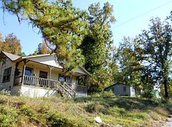
Abandoned houses in Gantts Quarry | |
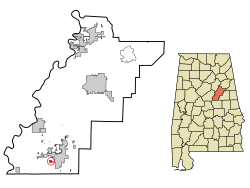
![]() Location in Talladega County and the state of Alabama | |
Coordinates: 33°08′54″N86°17′22″W / 33.14833°N 86.28944°W | |
Country | United States |
State | Alabama |
County | Talladega |
Area | |
• Total | 0.3 sq mi (0.9 km2) |
• Land | 0.3 sq mi (0.9 km2) |
• Water | 0 sq mi (0 km2) |
Elevation | 633 ft (193 m) |
Population (2020) | |
• Total | 0 |
• Density | 0.0/sq mi (0.0/km2) |
Time zone | UTC-6 (Central (CST)) |
• Summer (DST) | UTC-5 (CDT) |
FIPS code | 01-28984 |
GNIS feature ID | 0118815 |
Gantts Quarry is a quarry and former town in Talladega County, Alabama, United States. The population was zero at the 2000, 2010, and 2020 censuses, [1] although it had seven residents as late as the 1998 population estimate. [2] Incorporated in 1910 to keep neighboring Sylacauga from annexing it, [3] it was officially disincorporated after its population dwindled to 0 effective 31 December 2001. [4]
The history of the town goes back to 1830 when Dr. Edward Gantt discovered white marble and was one of the first towns in the county. A block of marble from the area is in the Washington Monument. [5] The 1930 census showed a population of 542 but the Great Depression and dwindling demand for marble used in building construction began the towns decline. In 1940 the population was 456 and by 1973 it was down to 63 residents. According to the 1990 U.S. Census, the incorporated town of Gantt's Quarry had a population of seven. [5]
When the town was first established, the town was governed by a mayor, a five-member city council, and the odd citizen out served as the town clerk. Company housing was set up for the employees. By the late 1960s, the company that owned the Quarry decided to demolish the company owned houses and this forced the residents to move to other towns and communities.
The town had its own post office, which also served as a library. The post office is pictured below. It was moved from the Quarry to its new location behind the B.B. Comer Museum in Sylacauga.
By the time of the 2000 Census, the town shows a population of zero, [6] and much of it appears to have been annexed into the city of Sylacauga. Preventing such an annexation was most likely the reason the town incorporated in the first place.
Census | Pop. | Note | %± |
---|---|---|---|
1920 | 413 | — | |
1930 | 542 | 31.2% | |
1940 | 456 | −15.9% | |
1950 | 426 | −6.6% | |
1960 | 238 | −44.1% | |
1970 | 63 | −73.5% | |
1980 | 71 | 12.7% | |
1990 | 7 | −90.1% | |
2000 | 0 | −100.0% | |
2010 | 0 | — | |
2020 | 0 | — | |
U.S. Decennial Census [7] |
Gantts Quarry is located at 33°08'54" North, 86°17'22" West (33.152570, −86.28942). [8]
According to the United States Census Bureau, the location has a total area of 0.9 km2 (0.3 mi2), all land.
Coosa County is a county located in the east central portion of the U.S. state of Alabama. As of the 2020 census the population was 10,387. Its county seat is Rockford. Its name derives from a town of the Creek tribe and the Coosa River, which forms one of the county borders.
Talladega County is one of the sixty-seven counties located in the east central portion of the U.S. state of Alabama. As of the 2020 census, the population was 82,149. Its county seat is Talladega.
Goodwater is a town in Coosa County, Alabama, United States. At the 2020 census, the population was 1,291. It is part of the Talladega-Sylacauga Micropolitan Statistical Area.
Rockford is a town in Coosa County, Alabama, United States. At the 2020 census, the population was 349. The town is the county seat of Coosa County and is part of the Talladega-Sylacauga Micropolitan Statistical Area.
Childersburg is a city in Talladega County in the U.S. state of Alabama. It was incorporated in 1889. At the 2020 census, the population was 4,754. It has a history dating back before 1540, when it was noted as a village of the Coosa Nation visited by the Spanish explorer Hernando de Soto. It is said a member of De Soto’s crew fell ill and was left to settle in the area of present day Childersburg where the Coosa people cared for the ill explorer. The Alabama Army Ammunition Plant, important during World War II, was located 4 miles (6 km) north of Childersburg.
Oak Grove is a town in Talladega County, Alabama, United States. It incorporated in 1966. At the 2020 census, the population was 564.
Sylacauga is a city in Talladega County, Alabama, United States. At the 2020 census, the population was 12,578.
Talladega is the county seat of Talladega County, Alabama, United States. It was incorporated in 1835. At the 2020 census, the population was 15,861. Talladega is approximately 50 miles (80 km) east of one of the state's largest cities, Birmingham.
Talladega Springs is a town in Talladega County, Alabama, United States. At the 2020 census, the population was 144.
Waldo is a town in Talladega County, Alabama, United States. It incorporated in 1972. At the 2020 census, the population was 258.
Natural Bridge is a town at the southwest edge of Winston County, Alabama, United States, located near the intersection of U.S. Route 278, Alabama Highway 13, and Alabama State Route 5. It initially incorporated on September 3, 1914. In the 1930s, due to a dwindling population, its charter became dormant. On July 24, 1997, it reincorporated.
Hampton is a city in southwestern Henry County, Georgia, United States. The population as of the 2020 census was 8,368. It is a southeastern suburb in the Atlanta metropolitan area.
New Columbus is a borough that is located in Luzerne County, Pennsylvania, United States. The population was 219 at the time of the 2020 census.
Damon is a census-designated place (CDP) in Brazoria County, Texas, United States. The population was 436 at the 2020 census. The town is located about 20 miles (32 km) south of Rosenberg on Texas State Highway 36. Damon sits partly atop a salt dome which was exploited for petroleum, sulphur, and limestone.
WSGN is a radio station broadcasting an oldies format. Licensed to Stewartville, Alabama, United States, it serves East Central Alabama. The station is owned and operated by Marble City Media LLC.
The Montgomery, Alabama Metropolitan Statistical Area is a metropolitan area in central Alabama. As of 2020, the MSA had a population of 386,047, ranking it 142nd among United States Metropolitan Statistical Areas. That number is up +3.07% from the 2010 census number of 374,536.
Kellyton is an incorporated town in Coosa County, Alabama, United States. It had a population of 217 as of the 2010 census.
Sylacauga marble, also commonly known as Alabama marble, is a marble that is found in a belt running through Talladega County, Alabama. It is prized for its pure white color and its crystalline structure. The stone is named after the town of Sylacauga, Alabama, which is sometimes called "the Marble City". Sylacauga marble has been called the "world's whitest". Discovered in 1814, it has been mined for over 160 years, and is used for building, sculpture, and industry. The Alabama Legislature passed Act 755 on September 12, 1969, which made this marble the state's official rock.
The Talladega-Sylacauga Micropolitan Statistical Area is a micropolitan statistical area that consisted of two counties in Alabama, anchored by the cities of Talladega and Sylacauga, as defined by the United States Census Bureau and the United States Office of Management and Budget. The area is also included in the Birmingham-Hoover-Talladega, Alabama Combined Statistical Area. As of the 2010 census, the μSA had a population of 93,830.
{{cite web}}
: CS1 maint: archived copy as title (link){{cite web}}
: CS1 maint: archived copy as title (link)