Related Research Articles

The North Pennines is the northernmost section of the Pennine range of hills which runs north–south through northern England. It lies between Carlisle to the west and Darlington to the east. It is bounded to the north by the Tyne Valley and to the south by the Stainmore Gap.
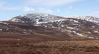
The Cheviot is an extinct volcano and the highest summit in the Cheviot Hills and in the county of Northumberland. Located in the extreme north of England, it is a 1+1⁄4-mile (2-kilometre) walk from the Scottish border and, with a height of 2,674 feet above sea-level, is located on the northernmost few miles of the Pennine Way, before the descent into Kirk Yetholm.
The geology of Shropshire is very diverse with a large number of periods being represented at outcrop. The bedrock consists principally of sedimentary rocks of Palaeozoic and Mesozoic age, surrounding restricted areas of Precambrian metasedimentary and metavolcanic rocks. The county hosts in its Quaternary deposits and landforms, a significant record of recent glaciation. The exploitation of the Coal Measures and other Carboniferous age strata in the Ironbridge area made it one of the birthplaces of the Industrial Revolution. There is also a large amount of mineral wealth in the county, including lead and baryte. Quarrying is still active, with limestone for cement manufacture and concrete aggregate, sandstone, greywacke and dolerite for road aggregate, and sand and gravel for aggregate and drainage filters. Groundwater is an equally important economic resource.

The geology of Wales is complex and varied; its study has been of considerable historical significance in the development of geology as a science. All geological periods from the Cryogenian to the Jurassic are represented at outcrop, whilst younger sedimentary rocks occur beneath the seas immediately off the Welsh coast. The effects of two mountain-building episodes have left their mark in the faulting and folding of much of the Palaeozoic rock sequence. Superficial deposits and landforms created during the present Quaternary period by water and ice are also plentiful and contribute to a remarkably diverse landscape of mountains, hills and coastal plains.
The geology of Monmouthshire in southeast Wales largely consists of a thick series of sedimentary rocks of different types originating in the Silurian, Devonian, Carboniferous, Triassic and Jurassic periods.

The Cheviot Hills, or sometimes The Cheviots, are a range of uplands straddling the Anglo-Scottish border between Northumberland and the Scottish Borders. The English section is within the Northumberland National Park. The range includes The Cheviot, plus Hedgehope Hill to the east, Windy Gyle to the west, and Cushat Law and Bloodybush Edge to the south.
The geology of County Durham in northeast England consists of a basement of Lower Palaeozoic rocks overlain by a varying thickness of Carboniferous and Permo-Triassic sedimentary rocks which dip generally eastwards towards the North Sea. These have been intruded by a pluton, sills and dykes at various times from the Devonian Period to the Palaeogene. The whole is overlain by a suite of unconsolidated deposits of Quaternary age arising from glaciation and from other processes operating during the post-glacial period to the present. The geological interest of the west of the county was recognised by the designation in 2003 of the North Pennines Area of Outstanding Natural Beauty as a European Geopark.
The geology of Tyne and Wear in northeast England largely consists of a suite of sedimentary rocks dating from the Carboniferous and Permian periods into which were intruded igneous dykes during the later Palaeogene Period.
The geology of Northumberland in northeast England includes a mix of sedimentary, intrusive and extrusive igneous rocks from the Palaeozoic and Cenozoic eras. Devonian age volcanic rocks and a granite pluton form the Cheviot massif. The geology of the rest of the county is characterised largely by a thick sequence of sedimentary rocks of Carboniferous age. These are intruded by both Permian and Palaeogene dykes and sills and the whole is overlain by unconsolidated sediments from the last ice age and the post-glacial period. The Whin Sill makes a significant impact on Northumberland's character and the former working of the Northumberland Coalfield significantly influenced the development of the county's economy. The county's geology contributes to a series of significant landscape features around which the Northumberland National Park was designated.
The geology of the Isle of Man consists primarily of a thick pile of sedimentary rocks dating from the Ordovician period, together with smaller areas of later sedimentary and extrusive igneous strata. The older strata was folded and faulted during the Caledonian and Acadian orogenies The bedrock is overlain by a range of glacial and post-glacial deposits. Igneous intrusions in the form of dykes and plutons are common, some associated with mineralisation which spawned a minor metal mining industry.
This article describes the geology of the Cairngorms National Park, an area in the Highlands of Scotland designated as a national park in 2003 and extended in 2010. The Cairngorms National Park extends across a much wider area than the Cairngorms massif itself and hence displays rather more varied geology.

The geology of England's Lake District is dominated by sedimentary and volcanic rocks of mainly Ordovician age underpinned by large granitic intrusions. Younger sedimentary sequences outcrop on the edges of the Lake District area, with Silurian to the south, Carboniferous to the north, east, and west and Permo-Triassic to the west and east. The entire area was covered by a Mesozoic sequence that was eroded off during the Paleogene uplift related to the opening of the North Atlantic. During the Quaternary the area was affected by repeated glaciations, which sculpted the current mountainous landscape.

The geology of Bosnia & Herzegovina is the study of rocks, minerals, water, landforms and geologic history in the country. The oldest rocks exposed at or near the surface date to the Paleozoic and the Precambrian geologic history of the region remains poorly understood. Complex assemblages of flysch, ophiolite, mélange and igneous plutons together with thick sedimentary units are a defining characteristic of the Dinaric Alps, also known as the Dinaride Mountains, which dominate much of the country's landscape.
The geology of Bhutan is less well studied than many countries in Asia, together with the broader Eastern Himalayas region. Older Paleozoic and Precambrian rocks often appear mixed together with younger sediments due to the Himalayan orogeny.
The geology of the Czech Republic is very tectonically complex, split between the Western Carpathian Mountains and the Bohemian Massif.
The geology of Yukon includes sections of ancient Precambrian Proterozoic rock from the western edge of the proto-North American continent Laurentia, with several different island arc terranes added through the Paleozoic, Mesozoic and Cenozoic, driving volcanism, pluton formation and sedimentation.
This article describes the geology of Dartmoor National Park in Devon, in south-west England. Dartmoor gained national park status in 1951 but the designated area of 954 km2 (368 sq mi) extends beyond the upland of Dartmoor itself to include much of the surrounding land, particularly in the northeast. The geology of the national park consists of a 625 km2 (241 sq mi) core of granite intruded during the early Permian period into a sequence of sedimentary rocks originating in the Devonian and Carboniferous periods. These rocks were faulted and folded, sometimes, intensely, during the Variscan orogeny. Thermal metamorphism has also taken place around the margins of the granite pluton altering the character of the sedimentary rocks whilst mineral veins were emplaced within the granite. A small outlier of Palaeogene sediments occurs on the eastern boundary of the national park.
The geology of national parks in Britain strongly influences the landscape character of each of the fifteen such areas which have been designated. There are ten national parks in England, three in Wales and two in Scotland. Ten of these were established in England and Wales in the 1950s under the provisions of the National Parks and Access to the Countryside Act 1949. With one exception, all of these first ten, together with the two Scottish parks were centred on upland or coastal areas formed from Palaeozoic rocks. The exception is the North York Moors National Park which is formed from sedimentary rocks of Jurassic age.
The geology of Loch Lomond and The Trossachs National Park in the southwestern part of the Scottish Highlands consists largely of Neoproterozoic and Palaeozoic bedrock faulted and folded and subjected to low grade metamorphism during the Caledonian orogeny. These older rocks, assigned to the Dalradian Supergroup, lie to the northwest of the northeast – southwest aligned Highland Boundary Fault which defines the southern edge of the Highlands. A part of this mountainous park extends south of this major geological divide into an area characterised by younger Devonian rocks which are assigned to the Old Red Sandstone.

Volcanic and igneous plumbing systems (VIPS) consist of interconnected magma channels and chambers through which magma flows and is stored within Earth's crust. Volcanic plumbing systems can be found in all active tectonic settings, such as mid-oceanic ridges, subduction zones, and mantle plumes, when magmas generated in continental lithosphere, oceanic lithosphere, and in the sub-lithospheric mantle are transported. Magma is first generated by partial melting, followed by segregation and extraction from the source rock to separate the melt from the solid. As magma propagates upwards, a self-organised network of magma channels develops, transporting the melt from lower crust to upper regions. Channelled ascent mechanisms include the formation of dykes and ductile fractures that transport the melt in conduits. For bulk transportation, diapirs carry a large volume of melt and ascent through the crust. When magma stops ascending, or when magma supply stops, magma emplacement occurs. Different mechanisms of emplacement result in different structures, including plutons, sills, laccoliths and lopoliths.
References
- ↑ British Geological Survey 1:625,000 scale geological map Bedrock Geology UK North 5th Edn. NERC 2007
- ↑ "Things to do; enjoy-nature". Northumberland National Park. Northumberland National Park Authority. Retrieved 16 November 2019.
- ↑ "BGS Lexicon of Named Rock Units - Result Details". Bgs.ac.uk. Retrieved 17 February 2019.
- ↑ "Things to do; enjoy nature". Northumberland National Park. Northumberland National Park Authority. Retrieved 16 November 2019.
- ↑ Stone, P. et al 2010 British Regional Geology: Northern England (5th edn) (Keyworth, Nottingham: British Geological Survey),pp184-5
- ↑ Stone, P. et al 2010 British Regional Geology: Northern England (5th edn) (Keyworth, Nottingham: British Geological Survey), pp212-3
- ↑ British Geological Survey 1:625,000 scale geological map Quaternary Map of the United Kingdom South 1st Edn. 1977