Geology of the Cairngorms National Park

Last updated

This article describes the geology of the Cairngorms National Park, an area in the Highlands of Scotland designated as a national park in 2003 and extended in 2010. The Cairngorms National Park extends across a much wider area than the Cairngorms massif itself and hence displays rather more varied geology.

Contents

The majority of the rocks within the National Park belong to the Dalradian Supergroup, a thick sequence of sands, muds and limestones that were deposited between about 800 and 600 million years ago on the margins of the former continent of Laurentia. [1] Rocks now ascribed to the Moine Supergroup occur along the northwestern edge of the Park.

The Dalradian and Moine successions were intensely faulted, folded and metamorphosed during the Caledonian Orogeny between about 490 and 430 million years ago [2] Geologists recognize a ‘Grampian event’, centred around 470 million years ago, which was responsible for the initial deformation of the Dalradian and relates to the collision of a volcanic island arc with Laurentia over a period of about 20 million years. The subsequent collision of Baltica with Laurentia caused the ‘Scandian event’ which involved further folding and faulting of the Dalradian rock sequence. The Great Glen, Ericht-Laidon and Glen Tilt faults were all active as strike-slip faults at this time and may have played a part in allowing large plutons of granite to rise up amongst the Dalradian rocks and then cool in situ. [3]

The largest of these plutons is the granite mass which forms the Cairngorms themselves and which was emplaced around 427 million years ago. It is thought that the pluton had been unroofed within 20 million years of its emplacement and that the present landscape of the Cairngorms had begun to form by 390 million years ago. Evidence suggests that the granite currently at the surface was initially to be found at a depth of between 4 and 7 km. [2]

Other than a small outlier of Old Red Sandstone, there are no younger solid rocks within the National Park. The ice ages of the last 2.5 million years have however left their mark both in terms of erosional and depositional features. Post-glacial features include peat and landslips.

Moine Supergroup

The metamorphic rocks of the Moine are generally identified with the Northwest Highlands west of the Great Glen Fault but there are some similar rocks east of the fault which are tentatively assigned to the Moine succession.

The Markie Gneiss is a unit of micaceous psammite within fault-bounded blocks on the western margin of the National Park. It is of Neoproterozoic age but its exact relationship to other strata continues to be debated. [4]

Badenoch Group

The oldest rocks within the area are those of the Tonian age Badenoch Group, [5] which occur along the northwestern edge of the national park. These rocks were formerly referred to as the Central Highland Division or Central Highland Migmatite Complex and have been included both within the Moine and Dalradian successions at various times. Estimates of age have varied but an age of around 900 million years is suggested by the British Geological Survey. [6] They are largely psammites and semipelites which have been intensely deformed and which are generally heavily migmatised. The group is divided into a lower part, the Dava Subgroup (previously the ‘Dava Succession’ and named after the Dava district between Grantown-on-Spey and Inverness) and an upper part, the Glen Banchor Subgroup (named after Glen Banchor which extends west from Newtonmore). Though its lower (western) boundary is not seen, the whole sequence is believed to be several kilometres thick. The nature of its upper boundary with Grampian Group rocks in the east has been disputed. The latter may rest unconformably on the Glen Banchor rocks or else the relationship may be wholly tectonic in nature i.e. faulted or sheared. [7] Within the groups are various named formations:

Badenoch Group rocks crop out northwest of a line running southwest from the Grantown Pluton towards the Boat of Garten and Monadhliath plutons. Within this area, a broad band of non-migmatised psammites extends beneath Carrbridge area and is well exposed further north at Creag an Righ, west of Grantown.

Dalradian Supergroup

Besides intrusive igneous rocks, the rest of the National Park is almost exclusively formed in metamorphosed strata collectively known as the Dalradian Supergroup or simply the Dalradian. They are a complex mix of psammites, phyllites, pelites, semipelites, quartzites and meta-limestones and other lithologies originally laid down as marine sand, mud, silt etc. in a depositional basin which alternately deepened and was filled over an extended period of time. The total thickness of this sequence is estimated at 25 km or more though the full thickness is unlikely ever to have accumulated at any one location [10] A variety of dates have been suggested for the age of the succession but sedimentation perhaps took place broadly between about 750 and 500 million years ago. [6]

The Dalradian is divided into four groups which stretch across the Grampian Highlands from Argyll in the southwest to northeast Scotland. All four groups and their various constituent subgroups and formations are seen within the National Park. The broad stratigraphy of the Dalradian is (oldest at bottom of list, youngest at top):

Grampian Group

The Grampian Group is the oldest division of the Dalradian and is recognized from Islay to Nairn and is also seen on the Atlantic coast of Ireland. It is itself divided into three parts; the Glenshirra, Corrieyairack and Glen Spean subgroups. The succession is considered to be 7–8 km thick and composed of psammites and semipelites and quartzites. The lowermost (i.e. oldest) strata within the group (overlying the rocks of the Badenoch Group) are meta-limestones and pelites, referred to at one time as the Ord Ban Subgroup but now referred to as the Grantown Formation and placed within the Glenshirra Subgroup. They may have originated as shallow marine shelf deposits. [11] Overlying these are the rocks of the Corrieyairick Subgroup which are thought to have originally been turbidites and represent a time of rifting and basin development. The following formations are recognized within the subgroup: Creag Meagaidh Psammite, Ardair Semipelite, Elrick Psammite and Semipelite, Loch Laggan Psammite, Kincraig, Coire nan Laogh Semipelite and Ruthven Semipelite formations. The youngest Grampian Group rocks are those of the Glen Spean Subgroup, originally nearshore and tidal deposits laid down at a time when the depositional basin was gradually filling. Within this subgroup are the Grantown Formation, Feshiebridge Formation, Coylumbridge Formation [12] and Pityoulish Formation. [13] The following formations are recognised within the undivided Grampian Group: Tormore Psammite, Nethybridge Psammite, Knockando Quartzite, Pityoulish and Dallas Psammite formations.

Appin Group

Overlying the Grampian Group is the Appin Group which is divided into three subgroups, the oldest being the Lochaber and the youngest the Blair Atholl with the Ballachulish separating the two. It was formerly referred to as the Lower Dalradian or Lower Dalradian Group. [14] The rocks of the Lochaber Subgroup, sometimes encountered in earlier references as the Lochaber (Transition) Subgroup [15] Much of this succession represents tidal and shelf deposits as the basin gradually subsided and deepened. The subgroup includes the Tom na Fianaig, Fodderletter Calcareous Flag, Riabhach Banded and Dalvrecht Slate formations. The Ballachulish Subgroup was formerly referred to as the Ballachulish Group. [16] It includes the Ailnack Phyllite and Limestone, Corryhabbie Quartzite and Mortlach Graphitic Schist formations. The youngest Appin rocks are those of the Blair Atholl Subgroup, previously referred to as the Blair Atholl Series. [17] These were laid down during a period of basin filling. They include the Glenfiddich Pelite, Tornahaish Dark Schist and Limestone, Inchrory Limestone, Clashnoir Semipelite and Neilead Limestone formations.

Argyll Group

The Islay Subgroup is the oldest/lowermost division of the group and includes the Kymah Quartzite, Auchnahyle, Ladder Hills and Nochty Semipelite and Limestone formations. Overlying this is the Easdale Subgroup which includes the Badenyon Schist and Limestone, Reppachie Semipelitic Schist, Glenbuchat Graphitic Schist, Lynavoir Semipelite and Culchavie Striped formations. Within the overlying Crinan Subgroup is the Queens Hill Gneiss Formation (or Queen's Hill Formation). The youngest part of the Argyll Group is the Tayvallich Subgroup. It contains the Deeside Limestone Formation. Certain stratigraphic relationships within the Argyll Group are uncertain but the group also includes the Craigievar, Blackwater and Scors Burn Schist formations.

Southern Highland Group

The Southern Highland Group is the youngest part of the Dalradian and occurs in the southeast of the park around Glen Prosen and from Glen Clova east to Loch Lee in Glen Esk, Its wider extent stretches from Northern Ireland to the North Sea coast including southern Shetland. The larger part of Glen Clova is cut into rocks of the Southern Highland Group rocks whilst the neighbouring mountains of Mayar and Driesh are formed from these same rocks. It includes the Clashindarroch and Suie Hill formations.

Old Red Sandstone

An outlier of the Lower Old Red Sandstone occurs around the Tomintoul area. Principally Devonian age sandstones, they contain siltstones too and a basal conglomerate. These strata are collected together as the Tomintoul Group and consist of a lower Delnabo Conglomerate Formation, an overlying Raebeg Sandstone Formation and an upper Conglass Sandstone Formation. The lower part of this sequence may be latest Silurian in age. [18]

Theses rocks form hills such as Carn na Farraidh, Carn Meadhonach and Tom na Bal to the west and south of Tomintoul. No solid rocks of late Devonian or succeeding periods are recorded within the area of the National Park.

Plutons

Numerous plutons were emplaced within the Dalradian sequence at the close of the Caledonian Orogeny from late Silurian to early Devonian times. These have been be divided into a ‘Cairngorm suite’, an ‘Argyll and Northern Highland suite’ and a ‘South of Scotland suite’ on the basis of different geochemical characteristics. [19] There are also variations in lithology within individual plutons.

The largest pluton within the National Park (by area) and the one which has the most dramatic effect on the landscape is the centrally located Cairngorm pluton. It extends over an area of about 365 square kilometres and was emplaced around 427 million years ago. [20] The Mount Battock pluton is of a similar size but only the western portion of it falls within the national park.

Structure

The geological structures within the area are complex, being the product of multiple deformational events. Two late Proterozoic events were followed by a further event during the Ordovician and Silurian. Metamorphism was associated with some of the deformational events. [21]

The Ericht-Laidon Fault is a major northeast–southwest aligned structure passing through the west of the Park. Though little exposed at the surface, it has been mapped passing beneath Grantown-on-Spey and, outside the Park's southwestern border, running the length of both Loch Ericht and Loch Laidon from which it takes its name. The similarly aligned Loch Tay Fault is a major landscape-forming feature running through the centre of the Park. It is mapped along the length of the notably straight Glen Tilt, passing out of the Park immediately west of Blair Atholl, en route for the Highland border via the central alignment of the loch which gives it its name. It also runs through Clais Fhearnaig, a glacial meltwater channel which connects Glen Lui and Glen Quoich. It defines the eastern margin of the Cairngorm pluton before running into Glen Builg at its northeastern end. The Bridge of Garry-Loch Balgie Fault is a third member of this group entering the Park from the southwest in the vicinity of Dalnaspidal Lodge. They are considered to be members of a family of faults with associated movement histories which includes the Great Glen Fault with which they run in parallel.

The Grampian Shear Zone, otherwise referred to as the Grampian Slide Zone juxtaposes rocks of the Badenoch Group against those of the Grampian Group. It has been dated to around 750 million years ago.

Quaternary

Within Britain, the Cairngorm landscape is considered to be of the very highest importance for its glacial geomorphology. [22] It displays a large number and wide range of features associated with glaciation and periglaciation including corries and glacial troughs, moraines, kames, eskers and other depositional features, pro-talus ramparts, meltwater channels. Corrie lakes of glacial origin occur at Loch nan Eun and Lochnagar beneath the mountain of Lochnagar, Loch Brandy and Loch Wharral above Glen Clova, Lochan nan Gabhar beneath Ben Avon and Dubh Lochan beneath Beinn a Bhuird. There are several Lochan Uaine's within the central Cairngorms alongside Loch Etchachan and Loch Coire an Lochain. Loch Kander is another with a glacial origin near the head of Glen Callater. On the eastern margins of the Monadhliath are Lochan a Choire beneath Geal Charn and Loch Dubh. Besides corries, nivation hollows are present such as that at Ciste Mhearaid. [23] Amongst the most significant glacial troughs are those of Loch Avon, Glen Einich, the Lairig Ghru and Strath Nethy within the Cairngorm massif and those of Loch Muick and Glen Clova in the wider Park. [24] Meltwater channels are common, notable examples being those at Chalamain Gap and Eag a’ Chait east of the Lairig Ghru, the Ryvoan Pass east of Glenmore and Clais Fhearnaig between Glen Lui and Glen Quoich. The various deposits associated with the Devensian (last) ice age are collectively known as the Caledonia Glacigenic Group and include the Central Grampian and East Grampian Glacigenic subgroups in this area.

Tors

Tors are a common feature of the Cairngorm granite massif, being especially frequent on Ben Avon and Beinn Mheadhoin and impressively high on Bynack More. They represent masses of granite which are less closely jointed than surrounding rock and which have therefore been less susceptible to underground weathering associated with fluid percolation along joints. The present tors have been exhumed, over a long period of time, not least by periglacial processes associated with ice ages during the Quaternary period. [25]

Related Research Articles

Old Red Sandstone Assemblage of rocks in the North Atlantic region

The Old Red Sandstone is an assemblage of rocks in the North Atlantic region largely of Devonian age. It extends in the east across Great Britain, Ireland and Norway, and in the west along the northeastern seaboard of North America. It also extends northwards into Greenland and Svalbard. These areas were a part of the ancient continent of Euramerica/Laurussia. In Britain it is a lithostratigraphic unit to which stratigraphers accord supergroup status and which is of considerable importance to early paleontology. For convenience the short version of the term, ORS is often used in literature on the subject. The term was coined to distinguish the sequence from the younger New Red Sandstone which also occurs widely throughout Britain.

Cairngorms National Park National park in Scotland

Cairngorms National Park is a national park in northeast Scotland, established in 2003. It was the second of two national parks established by the Scottish Parliament, after Loch Lomond and The Trossachs National Park, which was set up in 2002. The park covers the Cairngorms range of mountains, and surrounding hills. Already the largest national park in the United Kingdom, in 2010 it was expanded into Perth and Kinross.

Highland Boundary Fault Geological fault zone crossing Scotland

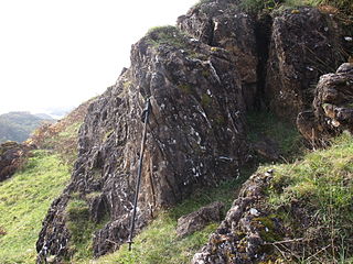
The Highland Boundary Fault is a major fault zone that traverses Scotland from Arran and Helensburgh on the west coast to Stonehaven in the east. It separates two different geological terranes which give rise to two distinct physiographic terrains: the Highlands and the Lowlands, and in most places it is recognisable as a change in topography. Where rivers cross the fault, they often pass through gorges, and the associated waterfalls can be a barrier to salmon migration.

Dalradian

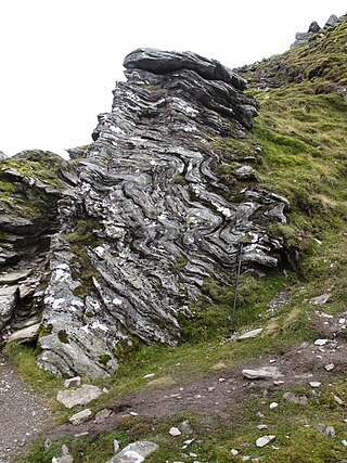
The Dalradian Supergroup is a stratigraphic unit in the lithostratigraphy of the Grampian Highlands of Scotland and in the north and west of Ireland. The diverse assemblage of rocks which constitute the supergroup extend across Scotland from Islay in the west to Fraserburgh in the east and are confined by the Great Glen Fault to the northwest and the Highland Boundary Fault to the southeast. Much of Shetland east of the Walls Boundary Fault is also formed from Dalradian rocks. Dalradian rocks extend across the north of Ireland from County Antrim in the north east to Clifden on the Atlantic coast, although obscured by later Palaeogene lavas and tuffs or Carboniferous rocks in large sections.

The Northwest Highlands are located in the northern third of Scotland that is separated from the Grampian Mountains by the Great Glen. The region comprises Wester Ross, Assynt, Sutherland and part of Caithness. The Caledonian Canal, which extends from Loch Linnhe in the south-west, via Loch Ness to the Moray Firth in the north-east splits this area from the rest of the country. The city of Inverness and the town of Fort William serve as gateways to the region from the south.

Argyll Group

The Argyll Group is a thick sequence of metamorphosed Neoproterozoic sedimentary rocks that outcrop across the Central Highlands of Scotland, east of the Great Glen, as well as appearing in the north of Ireland. It is a subdivision of the Dalradian Supergroup and is itself divided into four units; from oldest to youngest these are the Islay, Easdale, Crinan and Tayvallich subgroups.

The Lias Group or Lias is a lithostratigraphic unit found in a large area of western Europe, including the British Isles, the North Sea, the Low Countries and the north of Germany. It consists of marine limestones, shales, marls and clays.

Moine Supergroup

The Moine Supergroup is a sequence of Neoproterozoic metamorphic rocks that form the dominant outcrop of the Scottish Highlands between the Moine Thrust Belt to the northwest and the Great Glen Fault to the southeast. The sequence is metasedimentary in nature and was metamorphosed and deformed in a series of tectonic events during the Late Proterozoic and Early Paleozoic. It takes its name from A' Mhòine, a peat bog in northern Sutherland.

Exmoor Group

The Exmoor Group is a late Devonian to early Carboniferous lithostratigraphic group in southwest England whose outcrop extends from Croyde in north Devon east across Exmoor to Minehead in west Somerset. The group comprises the following formations the:

The Grampian Group is an estimated 9,000 m thick sequence of metamorphosed Neoproterozoic sedimentary rocks that outcrop across the Central Highlands of Scotland, east of the Great Glen. It forms a part of the Dalradian Supergroup. The sequence thickness at any one place is limited to 5km.

The geology of Northumberland in northeast England includes a mix of sedimentary, intrusive and extrusive igneous rocks from the Palaeozoic and Cenozoic eras. Devonian age volcanic rocks and a granite pluton form the Cheviot massif. The geology of the rest of the county is characterised largely by a thick sequence of sedimentary rocks of Carboniferous age. These are intruded by both Permian and Palaeogene dykes and sills and the whole is overlain by unconsolidated sediments from the last ice age and the post-glacial period. The Whin Sill makes a significant impact on Northumberland's character and the former working of the Northumberland Coalfield significantly influenced the development of the county's economy. The county's geology contributes to a series of significant landscape features around which the Northumberland National Park was designated.

Appin Group

The Appin Group is a thick sequence of metamorphosed Neoproterozoic sedimentary rocks that outcrop across the Central Highlands of Scotland, east of the Great Glen. It forms a part of the Dalradian Supergroup.

Southern Highland Group

The Southern Highland Group is a sequence of metamorphosed Neoproterozoic sedimentary rocks that outcrop across the Central Highlands of Scotland, east of the Great Glen. It forms the uppermost/youngest part of the Dalradian Supergroup and is divided into two formations. Volcanism is recorded by the Loch Avich Lavas Formation which divides the Loch Avich Grits Formation into lower and upper parts – the grits are turbidite and submarine fan deposits. In Perthshire and on Deeside, the Leny Limestone, which has been dated to 514 Ma, is present. A tillite, the Macduff Boulder Bed is known from the upper part of the group in northeast Scotland.


The Badenoch Group is a sequence of metamorphosed Tonian age sedimentary rocks that outcrop across the Central Highlands of Scotland, east of the Great Glen. This rock sequence has formerly been referred to as the Central Highland Migmatite Complex and the Central Highland Division.

The Ladder Hills are a range of hills in northeast Scotland which straddle the border between Aberdeenshire and Moray and form a part of the Grampian Mountains. The highest point of the range is Càrn Mòr at 804 metres (2,638 ft) which is classed as a Corbett; other named tops include Monadh an t-Sluich Leith (800m), Carn Liath (792m), Dun Muir (754m) and Little Geal Charn (742m).

The geology of national parks in Britain strongly influences the landscape character of each of the fifteen such areas which have been designated. There are ten national parks in England, three in Wales and two in Scotland. Ten of these were established in England and Wales in the 1950s under the provisions of the National Parks and Access to the Countryside Act 1949. With one exception, all of these first ten, together with the two Scottish parks were centred on upland or coastal areas formed from Palaeozoic rocks. The exception is the North York Moors National Park which is formed from sedimentary rocks of Jurassic age.

The geology of Loch Lomond and The Trossachs National Park in the southwestern part of the Scottish Highlands consists largely of Neoproterozoic and Palaeozoic bedrock faulted and folded and subjected to low grade metamorphism during the Caledonian orogeny. These older rocks, assigned to the Dalradian Supergroup, lie to the northwest of the northeast – southwest aligned Highland Boundary Fault which defines the southern edge of the Highlands. A part of this mountainous park extends south of this major geological divide into an area characterised by younger Devonian rocks which are assigned to the Old Red Sandstone.

The geology of Northumberland National Park in northeast England includes a mix of sedimentary, intrusive and extrusive igneous rocks from the Palaeozoic and Cenozoic eras. Devonian age volcanic rocks and a granite pluton form the Cheviot massif. The geology of the rest of the national park is characterised largely by a thick sequence of sedimentary rocks of Carboniferous age. These are intruded by Permian dykes and sills, of which the Whin Sill makes a significant impact in the south of the park. Further dykes were intruded during the Palaeogene period. The whole is overlain by unconsolidated sediments from the last ice age and the post-glacial period.

Geology of the Isle of Mull

The geology of the Isle of Mull in Scotland is dominated by the development during the early Palaeogene period of a ‘volcanic central complex’ associated with the opening of the Atlantic Ocean. The bedrock of the larger part of the island is formed by basalt lava flows ascribed to the Mull Lava Group erupted onto a succession of Mesozoic sedimentary rocks during the Palaeocene epoch. Precambrian and Palaeozoic rocks occur at the island's margins. A number of distinct deposits and features such as raised beaches were formed during the Quaternary period.

References

  1. Thomas, C.W.; Gillespie, M.R.; Jordan, C.J.; Hall, A.M. (2004). "Geological Structure and Landscape of the Cairngorm Mountains" (PDF). Commissioned report no 064. Scottish Natural Heritage. pp. 18, 21. Archived from the original (PDF) on 4 February 2018. Retrieved 3 February 2018.
  2. 1 2 Thomas, C.W.; Gillespie, M.R.; Jordan, C.J.; Hall, A.M. (2004). "Geological Structure and Landscape of the Cairngorm Mountains" (PDF). Commissioned report no 064. Scottish Natural Heritage. p. 18. Archived from the original (PDF) on 4 February 2018. Retrieved 3 February 2018.
  3. Thomas, C.W.; Gillespie, M.R.; Jordan, C.J.; Hall, A.M. (2004). "Geological Structure and Landscape of the Cairngorm Mountains" (PDF). Commissioned report no 064. Scottish Natural Heritage. p. 22. Archived from the original (PDF) on 4 February 2018. Retrieved 3 February 2018.
  4. "BGS Lexicon of Named Rock Units - Result Details". webapps.bgs.ac.uk.
  5. "BGS Lexicon of Named Rock Units - Result Details". webapps.bgs.ac.uk.
  6. 1 2 http://earthwise.bgs.ac.uk/images/a/a4/P915452.png [ bare URL image file ]
  7. "BGS Lexicon of Named Rock Units - Result Details". webapps.bgs.ac.uk.
  8. "BGS Lexicon of Named Rock Units - Result Details". webapps.bgs.ac.uk.
  9. "BGS Lexicon of Named Rock Units - Result Details". webapps.bgs.ac.uk.
  10. Woodcock and Strachan p73-4
  11. Woodcock and Strachan p76-77
  12. "BGS Lexicon of Named Rock Units - Result Details". webapps.bgs.ac.uk.
  13. "BGS Lexicon of Named Rock Units - Result Details". webapps.bgs.ac.uk.
  14. "BGS Lexicon of Named Rock Units - Result Details". webapps.bgs.ac.uk.
  15. "BGS Lexicon of Named Rock Units - Result Details". webapps.bgs.ac.uk.
  16. "BGS Lexicon of Named Rock Units - Result Details". webapps.bgs.ac.uk.
  17. "BGS Lexicon of Named Rock Units - Result Details". webapps.bgs.ac.uk.
  18. British Geological Survey 1996 ‘’Glenlivet’’. Scotland Sheet 75W Solid geology 1:50,000 (Keyworth, Nottingham: BGS)
  19. Highton, A.J. 1999 Solid Geology of the Aviemore District Memoir of the British Geological Survey Sheet 74E (Scotland) p57
  20. Thomas, C.W.; Gillespie, M.R.; Jordan, C.J.; Hall, A.M. (2004). "Geological Structure and Landscape of the Cairngorm Mountains" (PDF). Commissioned report no 064. Scottish Natural Heritage. p. 17. Archived from the original (PDF) on 4 February 2018. Retrieved 3 February 2018.
  21. Highton, A.J. (1999). Solid Geology of the Aviemore District (First ed.). British Geological Survey. p. 29. ISBN   011884539X.
  22. http://jncc.defra.gov.uk/pdf/gcrdb/GCRsiteaccount2284.pdf p17
  23. http://jncc.defra.gov.uk/pdf/gcrdb/GCRsiteaccount2284.pdf p13
  24. http://jncc.defra.gov.uk/pdf/gcrdb/GCRsiteaccount2284.pdf p15
  25. http://jncc.defra.gov.uk/pdf/gcrdb/GCRsiteaccount2284.pdf p3