Geology of the South Downs National Park

Last updated

The geology of the South Downs National Park in South East England comprises a gently folded succession of sedimentary rocks from the Cretaceous and early Palaeogene periods overlain in places by a range of superficial deposits from the last 2.6 million years. Whereas the South Downs are formed from the Late Cretaceous age chalk, the South Downs National Park extends into the Weald to the north of the range and thereby includes older rock strata dating from the Early Cretaceous including sandstones and mudstones. The youngest solid rocks are found on the southern fringes of the National Park in the eastern extension of the Hampshire Basin and include sand, silt and clay deposited during the Palaeocene and Eocene epochs.

Contents

Early Cretaceous strata

The oldest rocks encountered within the National Park are those of the Weald Clay Formation which stratigraphers place within the Wealden Group. They comprise a mix of sandstones, mudstones and limestones from the Hauterivian (c.139-129 Ma (million years ago)) and Barremian (c.129-124 Ma) stages. [1] These are succeeded (overlain) by the sandstones, mudstones and clays of the Lower Greensand Group. Four formations are present, within one of which five members are identifiable as mappable units. All were laid down during the Aptian stage (c.126-113 Ma), though the Folkestone Formation extends into the succeeding Albian stage (c.113-100.5 Ma). These strata are (uppermost/youngest at top):

Overlying the Lower Greensand are the two formations which comprise the Selborne Group; the Albian age Gault Formation and the Upper Greensand Formation which extends from the Albian into the Cenomanian (c.100.5-94 Ma) thereby straddling the boundary with the Late Cretaceous epoch. The highest point in the South Downs National Park is the 280m Black Down south of Haslemere, the summit of which is formed from sandstone of the Hythe Formation.

Chalk

Chalk is the rock type associated most closely with the National Park and, in common with the chalk which provides other key landscape features in the southeast of England, was formed by the settling to the sea floor of myriad coccoliths (microscopic plates of calcium carbonate formed by single-celled algae known as coccolithophores) during the Late Cretaceous epoch between about 100 and 70 million years ago. The Chalk Group which includes all of the different units which make up the succession in England, is subdivided into an earlier/lower Grey Chalk Subgroup and a later/higher White Chalk Subgroup. The Chalk has previously been subdivided in other ways and references to Upper, Middle and Lower abound in the literature and on geological maps. The Chalk is not homogeneous and within these two subgroups, numerous further units are distinguished, each with their own characteristics.

Grey Chalk Subgroup

The Grey Chalk Subgroup within the National Park is divided into two formations, an earlier West Melbury Marly Chalk Formation (within which the Glauconitic Marl Member is recognised) and a later Zig Zag Chalk Formation. All originate during the Cenomanian (100.5-94 Ma). The Grey Chalk is often described as marly, having a higher content of insoluble material - largely clay – than the White Chalk, and leading to it being less permeable. [2]

White Chalk Subgroup

The White Chalk Subgroup is locally divided into six formations, the uppermost of which is further subdivided into two members. Two distinct members are also identified within the lowermost formation. Ranging from Cenomanian to Campanian (c.84-72 Ma) in age, these strata are (uppermost/youngest at top):

The White Chalk is generally a more pure limestone and usually forms the main scarp face. [3] Amongst the exceptions are the ‘Plenus Marls’ which are a grey/green marly chalk up to 3m thick whilst the Melbourn Rock is a hard cream-coloured nodular chalk up to 5m thick. [4] The Newhaven Chalk typically forms a secondary scarp some distance to the south of the main scarp, and much less continuous in nature. [5] Bands of flint nodules occur throughout the chalk but are more numerous in parts of the succession than others. Flint is a variety of chert, a microcrystalline or cryptocrystalline form of quartz the mode of formation of which is still debated. [6]

Palaeogene strata

There are no rocks recorded within the area from the last part of the Cretaceous (the Maastrichtian age) nor the earliest parts of the following Paleogene period (Danian and Selandian ages).

Lambeth Group

A succession of sands, silts and clays date back to the Thanetian (c.59-56 Ma) and Ypresian (c.56-48 Ma) ages and named as the Lambeth Group. The Woolwich and Reading formations within this Group contain some thin lignites and shell beds in places. These rocks lie unconformably on an eroded surface of the Culver Chalk Formation and in places, the uppermost Newhaven Chalk.

Thames Group

Three formations occur within the boundaries of the National Park; uppermost/youngest at top, these strata are:

Geological structures

Geological strata within the area are flat-lying to moderately dipping. The major structure within southeast England is the Wealden Anticline, itself a part of the larger Weald-Artois Anticline, an upward folding of the entire Cretaceous succession along a broadly east-west axis. The South Downs are the eroded remnant of the southern limb of this regional-scale fold, paired with the North Downs which represent the opposing limb of this 'unroofed' elongate dome. The southerly dipping chalk beds of the South Downs present one of the major escarpments to be found in Britain. [7] A feature originating from the same tectonic causes is the Greensand Ridge, a significant north-facing scarp formed by the Lower Greensand (in particular the Hythe Beds sandstone) west of the Arun valley. The scarp runs sub-parallel to that of the chalk as far as Combe Hill, southeast of Liss where it turns to the northeast to exit the national park near Haslemere. [8]

To the south are the broadly parallel Portsdown and Littlehampton anticlines, separated from the Wealden Anticline by the Chichester Syncline. The synclinal axis comes ashore at Lancing (albeit the bedrock is thickly concealed by other deposits) and can be traced WNW to the south of Arundel. It passes through the fringes of the national park between West Durrington and Crossbush. A further gentle anticline is mapped running from the vicinity of Hailsham west towards Brighton and named as the Kingston-Beddingham Anticline. It is paired with the Caburn Syncline running through Lewes to its north. Each of these folds was formed during a phase of the Alpine Orogeny. Geological faults are inferred to run beneath the Moulsecoomb valley and the lower section of the Cuckmere valley whilst minor faults have been mapped elsewhere within the national park.

Quaternary landscape evolution and superficial deposits

Southeast England was not glaciated during the Quaternary period i.e. the last 2.6 million years but was subject to severe climate at times that has contributed to the shape of today’s landscape. It is theorised that many of the coombes which scallop the scarp of the South Downs were excavated by surface water flowing over perennially frozen ground thus rendering the normally permeable chalk impermeable. Frost action and solifluction will also have been contributors to their development. [9]

Clay-with-flints and head

The British Geological Survey map numerous residual deposits across the upper surfaces of the South Downs, derived from the solution, decalcification and cryoturbation of the underlying bedrock. Referred to as the Clay-with-flints Formation, the deposit also contains sand and silt in places. It varies from 0 to 10m in thickness but can exceed this where it fills solution hollows. [10] Where this and/or other material has moved down steeper slopes during the post-glacial period, it is referred to as head. [11] Head deposits are present in the base of most of the dry valleys which penetrate the Downs.

Effects of sea level changes

The Itchen, Meon, Lavant, Arun, Adur, Ouse and Cuckmere rivers each cut through the chalk ridge of the Downs conveying water from their north to the English Channel to the south. During times of lowered sea level as during the Last Glacial Period, each river was rejuvenated and cut down into its bed. As sea levels recovered to levels similar to today, the lower parts of the valleys were inundated by the sea to become rias. River-borne sediments (sand, silt and clay) then progressively infilled the rias. In places, similar material forms not only the modern floodplain but also river terraces perched at some height above it as a remnant of an earlier floodplain when sea levels were temporarily higher than those of today. [12]

Beach and tidal flats

Shingle, sand and gravel etc occur around the mouths of the Cuckmere and Ouse rivers. A storm beach extends from the mouth of the Ouse southeast to the end of the esplanade at Seaford. Sediments around Arundel are regarded as raised marine deposits. Each of these deposits is of Holocene age.

Artificial ground

Ground surfaces which have been raised or otherwise formed by human activity are classed as artificial. They include railway and major road embankments, together with quarry spoil and landfill for example. Small examples occur throughout the national park. Some of the more striking examples are those at Midhurst which are associated with the former Midhurst Brickworks.

Landslide deposits

Rock debris at the foot of the high chalk cliffs at Beachy Head at the eastern extremity of the national park is landslipped material. Cliff falls are common on the steep to vertical chalk cliffs of this coast, though most lie just outside of the national park. Several areas of landslip occur in the vicinity of Petersfield and north towards Farnham at the junction of the Gault with the overlying Upper Greensand. [13]

Conservation and recreation

Of the many Sites of Special Scientific Interest within the national park, ten are designated for their geological interest:

In addition to these, 50 sites have been designated as Local Geological Sites. [14] Sussex Heritage Coast was the first to be defined in England and Wales and protects the chalk-cliffed coast of the national park around Beachy Head and the Seven Sisters. [15]

The South Downs Way is a national trail which takes advantage of the north-facing chalk escarpment of the South Downs as it extends for the length of the national park from the margins of Eastbourne in the east to Winchester in the west.

See also

Related Research Articles

Downland Area of open chalk hills

For the ship anchorage, see The Downs.

North Downs Range of hills in south east England, UK

The North Downs are a ridge of chalk hills in south east England that stretch from Farnham in Surrey to the White Cliffs of Dover in Kent. Much of the North Downs comprises two Areas of Outstanding Natural Beauty (AONBs): the Surrey Hills and the Kent Downs. The North Downs Way National Trail runs along the North Downs from Farnham to Dover.

Chalk Group

The Chalk Group is the lithostratigraphic unit which contains the Upper Cretaceous limestone succession in southern and eastern England. The same or similar rock sequences occur across the wider northwest European chalk 'province'. It is characterised by thick deposits of chalk, a soft porous white limestone, deposited in a marine environment.

Greensand

Greensand or green sand is a sand or sandstone which has a greenish color. This term is specifically applied to shallow marine sediment that contains noticeable quantities of rounded greenish grains. These grains are called glauconies and consist of a mixture of mixed-layer clay minerals, such as smectite and glauconite mica. Greensand is also loosely applied to any glauconitic sediment.

Gault

The Gault Formation is a geological formation of stiff blue clay deposited in a calm, fairly deep-water marine environment during the Lower Cretaceous Period. It is well exposed in the coastal cliffs at Copt Point in Folkestone, Kent, England, where it overlays the Lower Greensand formation, and underlies the Upper Greensand Formation. These represent different facies, with the sandier parts probably being deposited close to the shore and the clay in quieter water further from the source of sediment; both are believed to be shallow-water deposits.

Geology of Dorset

Dorset is a county in South West England on the English Channel coast. Covering an area of 2,653 square kilometres (1,024 sq mi); it borders Devon to the west, Somerset to the north-west, Wiltshire to the north-east, and Hampshire to the east. The great variation in its landscape owes much to the underlying geology, which includes an almost unbroken sequence of rocks from 200 to 40 million years ago (Mya) and superficial deposits from 2 Mya to the present. In general, the oldest rocks appear in the far west of the county, with the most recent (Eocene) in the far east. Jurassic rocks also underlie the Blackmore Vale and comprise much of the coastal cliff in the west and south of the county; although younger Cretaceous rocks crown some of the highpoints in the west, they are mainly to be found in the centre and east of the county.

The geology of Hampshire in southern England broadly comprises a gently folded succession of sedimentary rocks dating from the Cretaceous and Palaeogene periods. The lower (early) Cretaceous rocks are sandstones and mudstones whilst those of the upper (late) Cretaceous are the various formations which comprise the Chalk Group and give rise to the county's downlands. Overlying these rocks are the less consolidated Palaeogene clays, sands, gravels and silts of the Lambeth, Thames and Bracklesham Groups which characterise the Hampshire Basin.

The Vale of Kent, located in Kent, England, is the name given to the broad clay vale between the Greensand Ridge and the High Weald. The area is drained by a number of rivers, including the Beult, Eden Medway, Stour and River Teise.

Greensand Ridge Range of hills in south east England, UK

The Greensand Ridge, also known as the Wealden Greensand is an extensive, prominent, often wooded, mixed greensand/sandstone escarpment in south-east England. Forming part of the Weald, a former dense forest in Sussex, Surrey and Kent, it runs to and from the East Sussex coast, wrapping around the High Weald and Low Weald. It reaches its highest elevation, 294 metres (965 ft), at Leith Hill in Surrey—the second highest point in south-east England, while another hill in its range, Blackdown, is the highest point in Sussex at 280 metres (919 ft). The eastern end of the ridge forms the northern boundary of Romney Marsh.

Geography of Kent Overview of the geography of Kent

Kent is the south-easternmost county in England. It is bounded on the north by the River Thames and the North Sea, and on the south by the Straits of Dover and the English Channel. The continent of Europe is 21 miles across the straits.

Lower Greensand Group Geological unit

The Lower Greensand Group is a geological unit present across large areas of Southern England. It was deposited during the Aptian and Albian stages of the Early Cretaceous. It predominantly consists of sandstone and unconsolidated sand that were deposited in shallow marine conditions.

Geology of East Sussex Overview of the geology of East Sussex

The geology of East Sussex is defined by the Weald–Artois anticline, a 60 kilometres (37 mi) wide and 100 kilometres (62 mi) long fold within which caused the arching up of the chalk into a broad dome within the middle Miocene, which has subsequently been eroded to reveal a lower Cretaceous to Upper Jurassic stratigraphy. East Sussex is best known geologically for the identification of the first dinosaur by Gideon Mantell, near Cuckfield, to the famous hoax of the Piltdown man near Uckfield.

Ashdown Formation

The Ashdown Formation is a geological unit, which forms part of the Wealden Group and the lowermost and oldest part of the now unofficial Hastings Beds. These geological units make up the core of the Weald in the English counties of East Sussex and Kent.

Geology of the Isle of Wight

The geology of the Isle of Wight is dominated by sedimentary rocks of Cretaceous and Paleogene age. This sequence was affected by the late stages of the Alpine Orogeny, forming the Isle of Wight monocline, the cause of the steeply-dipping outcrops of the Chalk Group and overlying Paleogene strata seen at The Needles, Alum Bay and Whitecliff Bay.

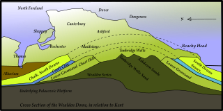
The geology of Kent in southeast England largely consists of a succession of northward dipping late Mesozoic and Cenozoic sedimentary rocks overlain by a suite of unconsolidated deposits of more recent origin.

The geology of Norfolk in eastern England largely consists of late Mesozoic and Cenozoic sedimentary rocks of marine origin covered by an extensive spread of unconsolidated recent deposits.

The geology of West Sussex in southeast England comprises a succession of sedimentary rocks of Cretaceous age overlain in the south by sediments of Palaeogene age. The sequence of strata from both periods consists of a variety of sandstones, mudstones, siltstones and limestones. These sediments were deposited within the Hampshire and Weald basins. Erosion subsequent to large scale but gentle folding associated with the Alpine Orogeny has resulted in the present outcrop pattern across the county, dominated by the north facing chalk scarp of the South Downs. The bedrock is overlain by a suite of Quaternary deposits of varied origin. Parts of both the bedrock and these superficial deposits have been worked for a variety of minerals for use in construction, industry and agriculture.

Geology of Surrey

The geology of Surrey is dominated by sedimentary strata from the Cretaceous, overlaid by clay and superficial deposits from the Cenozoic.

This article describes the geology of the New Forest, a national park in Hampshire, in Southern England.

The geology of the Peak District National Park in England is dominated by a thick succession of faulted and folded sedimentary rocks of Carboniferous age. The Peak District is often divided into a southerly White Peak where Carboniferous Limestone outcrops and a northerly Dark Peak where the overlying succession of sandstones and mudstones dominate the landscape. The scarp and dip slope landscape which characterises the Dark Peak also extends along the eastern and western margins of the park. Although older rocks are present at depth, the oldest rocks which are to be found at the surface in the national park are dolomitic limestones of the Woo Dale Limestone Formation seen where Woo Dale enters Wye Dale east of Buxton.

References

  1. "Weald Clay Formation". Lexicon of named rock units. British Geological Survey. Retrieved 22 April 2022.
  2. Goudie, Andrew (1990). The Landforms of England and Wales (First ed.). Oxford: Blackwell. p. 149. ISBN   0631173064.
  3. Goudie, Andrew (1990). The Landforms of England and Wales (First ed.). Oxford: Blackwell. p. 149. ISBN   0631173064.
  4. "England and Wales Sheet 318/333, Brighton and Worthing: Bedrock and Superficial Deposits". BGS Maps Portal. British Geological Survey. Retrieved 22 April 2022.
  5. "England and Wales sheet 316 Fareham, Solid and Drift Geology". Maps Portal. British Geological Survey. Retrieved 23 April 2022.
  6. "The Flints from Portsdown Hill". The Geology of Portsdown Hill. Archived from the original on 13 November 2007. Retrieved 23 April 2022.
  7. "Geology & Landscapes: Geology". SDNP Learning Zone. South Downs National Park Authority. Retrieved 23 April 2022.
  8. "SDNP Interactive map" (PDF). SDNP Learning Zone. South Downs National Park Authority. Retrieved 23 April 2022.
  9. Gallois, R.W. (1965). British Regional Geology: The Wealden District (Fourth ed.). London: Institute of Geological Sciences, HMSO. p. 72.
  10. "Clay-with-flints Formation". Lexicon of named rock units. British Geological Survey. Retrieved 22 April 2022.
  11. "Head". Lexicon of named rock units. British Geological Survey. Retrieved 22 April 2022.
  12. Gallois, R.W. (1965). British Regional Geology: The Wealden District (Fourth ed.). London: Institute of Geological Sciences, HMSO. p. 77.
  13. "GeoIndex Onshore". British Geological Survey. Retrieved 23 April 2022.
  14. "State of the National Park Report 2012" (PDF). South Downs National Park Authority. Retrieved 22 April 2022.
  15. "Heritage Coasts". Natural England. Retrieved 22 April 2022.