Gherang, Victoria

Last updated

Gherang
Victoria
Australia Victoria Surf Coast Shire location map.svg
Red pog.svg
Gherang
Coordinates 38°18′13″S144°05′26″E / 38.30361°S 144.09056°E / -38.30361; 144.09056
Population370 (2016 census) [1]
Postcode(s) 3240
Elevation144 m (472 ft)
Time zone AEST (UTC)
Location
LGA(s) Surf Coast Shire
County Australia
State electorate(s) Polwarth
Federal division(s) Corangamite
Localities around Gherang:
Wurdiboluc Modewarre Modewarre
Wurdiboluc Gherang Paraparap
Wensleydale Wensleydale
Anglesea
Anglesea

Gherang is a small rural township in Victoria, Australia. It is in the Surf Coast Shire local government area, and is on the northern edge of the Great Otway National Park and the Anglesea Heath. At the 2006 census, Gherang had a population of 370. [1] The area is mostly farmland, although there has been some rural-residential subdivision. Quarries in the area produce good quality gravel which is mostly used for roads.

Contents

History

Before British colonisation, the area had been home to the Gadubanud Aboriginal people for thousands of years. [2] Settlement by Europeans began in the mid-19th century and, as a consequence, the number of Gadubanud people rapidly declined.

The area was heavily forested and gravel suitable for roads was discovered. The Wensleydale railway line was completed in 1890, connecting the area to the Port Fairy railway line near Moriac, with the intention of inducing development along the route and transporting timber and firewood. [3] :7 A small station served Gherang but saw very little traffic.

However, in 1921, a rail siding about 700 metres south of the station was provided for the Gherang Gravel Conference, a grouping of three municipalities in the Geelong area, which was quarrying a large gravel deposit adjacent to the line. Considerable quantities of gravel were railed out until the operation ceased in 1939. [3] :16 Just over a kilometre south of the station, another rail siding was provided in 1926 for a privately-owned gravel quarrying operation, which functioned intermittently until 1941. [3] :48

During World War II, a small army base was established a few hundred metres east of the station, and materials and troops were brought in and out by train. The Gherang Military Post Office was open from 13 January 1942 until 22 September 1942, and from 15 February 1943 until 13 April 1943. Gherang has never had a civilian post office. [4] After the war, the line fell back into disuse and was permanently closed in 1948. [3] :16

Wildlife

Larger wildlife inhabiting Gherang include kangaroos, echidnas, koalas and the brushtail possum. Bird life in the area includes kookaburras, magpies, little ravens, willie wagtails, pigeons, quail, and a variety of parrot species. Reptiles include the brown snake, blue-tongued lizard and smaller skinks. There are pest species such as rabbits, foxes and feral cats.

Geothermal Power

In 2007, Greenearth Energy announced a plan to build several geothermal power plants in the Gherang area to harness heat from granite which is 4 km below ground. [5] Construction of a trial plant was planned to commence in the early 2010s but did not go ahead.

Australian Automotive Research Centre

South of Gherang is the Australian Automotive Research Centre, the largest privately owned and independently operated automotive testing facility in Australia. Occupying a 1000 hectare site, it includes a 4.2 km highway circuit, vehicle handling tracks, brake test surfaces, and four wheel drive test tracks.[ citation needed ]

Related Research Articles

<span class="mw-page-title-main">Werribee, Victoria</span> Suburb of Melbourne, Victoria, Australia

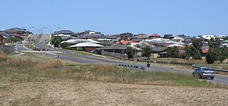
Werribee is a suburb in Melbourne, Victoria, Australia, 32 km (20 mi) south-west of Melbourne's Central Business District, located within the local government area of the City of Wyndham. Werribee recorded a population of 50,027 at the 2021 census.

<span class="mw-page-title-main">Grovedale, Victoria</span> Suburb of Geelong, Victoria, Australia

Grovedale is a southern suburb of Geelong, Victoria, Australia. At the 2021 census, Grovedale had a population of 14,869.

<span class="mw-page-title-main">Waurn Ponds, Victoria</span> Suburb of Geelong, Victoria, Australia

Waurn Ponds is a mainly residential southern suburb of Geelong, Victoria, Australia.

<span class="mw-page-title-main">North Shore, Victoria</span> Suburb of Geelong, Victoria, Australia

North Shore is an industrial and residential suburb of Geelong, Victoria, Australia. The suburb overlooks Corio Bay. A small residential area is east of the North Shore railway station with a few neighbourhood shops.

<span class="mw-page-title-main">South Geelong railway station</span> Railway station in Geelong, Victoria, Australia

South Geelong railway station is located on the Warrnambool line in Victoria, Australia. It serves the southern Geelong suburb of South Geelong, and it opened on 1 November 1883.

Mount Duneed is a suburb of Geelong, Victoria, Australia. It is divided between the City of Greater Geelong and Surf Coast Shire local government areas. Mount Duneed itself is an extinct volcano and the remains of the crater can be seen in the Mount Duneed Recreation Reserve.

<span class="mw-page-title-main">Forrest, Victoria</span> Town in Victoria, Australia

Forrest is a small rural township in the Otway Ranges, Victoria, Australia. At the 2016 census, Forrest and the surrounding area had a population of 230.

<span class="mw-page-title-main">Inverleigh, Victoria</span> Town in Victoria, Australia

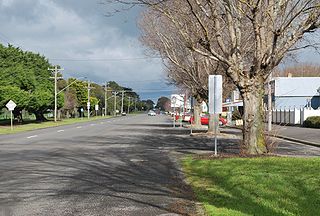
Inverleigh is a town in Victoria, Australia located 28 kilometres (17 mi) west from the City of Geelong and 87 kilometres (54 mi) from the state capital, Melbourne. The town is divided between Golden Plains Shire and Surf Coast Shire. In the 2021 census, the central area of Inverleigh had a population of 1,746. Inverleigh is known to be a popular stopover destination on the way to Lorne. The Inverleigh Hotel is very popular attracting customers from Geelong.

<span class="mw-page-title-main">Moriac, Victoria</span> Town in Victoria, Australia

Moriac is a town in Victoria, Australia, located approximately 22 kilometres (14 mi) west of Geelong. It forms part of the Surf Coast Shire. At the 2016 census, Moriac had a population of 782. A Post Office opened on 1 August 1854 as Duneed, was renamed Mount Moriac in 1864, and Moriac in about 1909.

<span class="mw-page-title-main">Moriac railway station</span> Former railway station in Victoria, Australia

Moriac is a closed station on the Warrnambool railway line, located in the town of Moriac, Victoria. The station opened on 1 October 1877, and was one of 35 stations in Victoria, and five on the Warrnambool line, which were closed to passenger traffic on 4 October 1981, as part of the so-called New Deal for country passengers.

<span class="mw-page-title-main">Beeac</span> Town in Victoria, Australia

Beeac is a town in the Western District of Victoria, Australia. The town is located on the shore of the hyper-saline Lake Beeac in the Colac Otway Shire local government area, 160 kilometres southwest of the state capital, Melbourne. At the 2016 census, Beeac had a population of 370.

<span class="mw-page-title-main">Warrnambool railway line</span> Railway line in Victoria, Australia

The Port Fairy railway line is a railway serving the south west of Victoria, Australia. Running from the western Melbourne suburb of Newport through the cities of Geelong and Warrnambool, the line once terminated at the coastal town of Port Fairy before being truncated to Dennington. This closed section of line has been converted into the 37 km long Port Fairy to Warrnambool Rail Trail. The line continues to see both passenger and freight services today.

<span class="mw-page-title-main">Shire of Barrabool</span> Local government area in Victoria, Australia

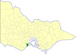
The Shire of Barrabool was a local government area about 100 kilometres (62 mi) southwest of Melbourne, the state capital of Victoria, Australia. The shire covered an area of 575.18 square kilometres (222.1 sq mi), and existed from 1853 until 1994.

Wensleydale is a small rural community in Victoria, Australia.

The Wensleydale railway line was a railway branch line in Victoria, Australia. It ran for approximately 18 km from the Port Fairy railway line near Moriac, to Wensleydale, Victoria. It was opened in March 1890 and was used to transport firewood, gravel and brown coal out of the area. Apart from troop trains during World War II the line saw very little traffic and was closed in 1948.

<span class="mw-page-title-main">Maxwelton, Queensland</span> Town in Queensland, Australia

Maxwelton is an outback town and locality in the Shire of Richmond in central north Queensland, Australia. In the 2016 census, the locality of Maxwelton had a population of 22 people.

Buckley is a rural locality in the Surf Coast Shire, Victoria, Australia. It was formerly known as Laketown. In the 2021 census, Buckley had a population of 227.

Paraparap is a rural locality in the Surf Coast Shire, Victoria, Australia. At the 2016 census, Paraparap had a population of 151 people.

Winchelsea South is a rural locality in the Surf Coast Shire, Victoria, Australia. In the 2016 census, Winchelsea South had a population of 179 people.

Benwerrin is a rural locality in the Surf Coast Shire, Victoria, Australia.

References

  1. 1 2 Australian Bureau of Statistics (27 June 2017). "Gherang (State Suburb)". 2016 Census QuickStats. Retrieved 16 November 2017. OOjs UI icon edit-ltr-progressive.svg
  2. "Acknowledging and Celebrating Aboriginal Heritage in the Surf Coast Shire" (PDF). Surfcoast Shire. Retrieved 10 December 2023.
  3. 1 2 3 4 Houghton, Norm (1982). The Saddle Line: A History of the Moriac to Wensleydale Railway. Geelong: self-published. ISBN   0 9593013 0 5.
  4. Premier Postal History. "Post Office List". Premier Postal Auctions. Retrieved 26 May 2011.
  5. "Greenearth Energy Project". ANGAIR. 3 June 2011. Retrieved 10 December 2023.