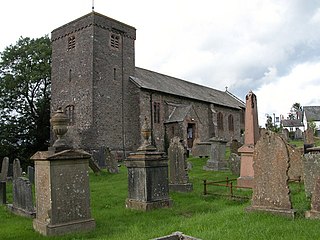
Llangammarch Wells or simply Llangammarch is a village in the community of Llangamarch in Powys, Wales, lying on the Afon Irfon, and in the historic county of Brecknockshire (Breconshire).

The Afon Mawddach is a river in Gwynedd, Wales, which has its source in a wide area SH820300 north of Dduallt in Snowdonia. It is 28 miles (45 km) in length, and is much branched; many of the significant tributaries are of a similar size to the main river. The catchment area is bounded to the east by the Aran Fawddwy massif and to the west and north by the Harlech dome which forms a watershed just south of Llyn Trawsfynydd.
The River Ystwyth is a river in Ceredigion, Wales. The length of the main river is 20.5 miles (33.0 km). Its catchment area covers 75 square miles (190 km2). Its source is a number of streams that include the Afon Diliw, located on the west slopes of Plynlimon on the border of Ceredigion and Powys in the Cambrian Mountains. The Ystwyth flows westwards before its confluence with the Afon Rheidol and the estuary at Aberystwyth to drain into Cardigan Bay.

Afon Rheidol is a river in Ceredigion, Wales, 19 miles (31 km) in length. The source is Plynlimon. Receiving an average annual rainfall of 40 inches (1.02 m), Plynlimon is also the source of both the Wye and the Severn.

Tanygrisiau is a village and area within Blaenau Ffestiniog in the upper end of the Vale of Ffestiniog in the county of Gwynedd, north-west Wales. It can be found along the southern side of the Moelwyn mountain range and dates to around 1750. It joins onto the semi-urban area of Blaenau Ffestiniog, and is in the community of Ffestiniog; located between 650 feet (200 m) and 750 feet (230 m) above sea level. it is in the electoral ward of Bowydd and Rhiw which had a 2011 census population of 1878. The village itself has a population of around 350.

Pumsaint is a village in Carmarthenshire, Wales, halfway between Llanwrda and Lampeter on the A482 in the valley of the Afon Cothi. It forms part of the extensive estate of Dolaucothi, which is owned by the National Trust.

Ponterwyd is a village in Ceredigion, Wales. It lies in the Cambrian Mountains of Mid Wales, approximately 12 miles (19 km) east of Aberystwyth on the A44 road.
The Plynlimon and Hafan Tramway was a 2 ft 3 in gauge narrow gauge railway in Cardiganshire in Mid Wales. It ran from Llanfihangel station on the Cambrian Line, through the village of Tal-y-bont and the valley of the Afon Leri, into the foothills of Plynlimon Fawr. It was built to serve the lead mines at Bwlch Glas and stone quarries around Hafan and opened in 1897, closing just two years later. The line was a little over 7 miles (11 km) long and, despite running a short-lived passenger service, it served no communities of more than 100 people.

Llanbrynmair or Llanbryn-mair is a village, community and electoral ward in Montgomeryshire, Powys, on the A470 road between Caersws and Machynlleth. Llanbrynmair, in area, is the second largest in Powys. In 2011, it had a population of 920.

Llangynog is a village and community at the confluence of the Afon Eirth and the Afon Tanat at the foot of the Berwyn range in north Powys, Wales.

Gladestry is a small village and community in Radnorshire, Powys, mid-Wales, close to the border with England at the end of the Hergest Ridge and south of the large moorland area of Radnor Forest. People living in Gladestry rely on the nearby town of Kington, Herefordshire, for shops, employment, and public services.
Afon Mynach is a river in Ceredigion, Wales.
Pentre Berw is a small village located on the island of Anglesey in north Wales. It lies about 2 miles (3.2 km) south of the county town of Llangefni, and next to Gaerwen.

Afon Cych is a tributary of the River Teifi in south-west Wales. It is 13 km long, passes through a number of small settlements on the border between Pembrokeshire and Carmarthenshire, and is significant in Welsh legend.

The Afon Dulas, or North Dulas, is a river forming the border between Merionethshire/Gwynedd and Montgomeryshire/Powys in Wales. Another river called Afon Dulas joins the Dyfi from the south, upstream of its confluence with the North Dulas: locally this is referred to as the South Dulas.
The River Brenig is a tributary river of the River Teifi and runs through the market town of Tregaron in Ceredigion, Wales.
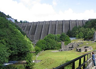
Bryntail lead mine is a disused lead mine near Llanidloes in Powys, Wales. Sited on the Afon Clywedog and in the shadow on the Clywedog reservoir dam, it is in the care of Cadw.
Ffarmers is a village near Lampeter, in the north of Carmarthenshire, Wales. It was named after the old "Farmers' Arms" public house, which is now closed. The double "f" in the name comes from the Welsh language spelling of the "f" sound in "farmers". The village stands on the old Roman road, Sarn Helen, which was used by cattle drovers to take their livestock from Wales to Smithfield market in London.

Afon Elan is a tributary of the River Wye which runs through the wide expanse of upland moors, traditionally known as Elenydd, in central Wales. Its valley is the Elan Valley. The name probably arises from elain meaning 'hind' or 'fawn' in reference perhaps to the rushing, bounding nature of its course.

Melindwr is a community in the county of Ceredigion, Wales, to the east of Aberystwyth and is 71.6 miles (115.1 km) from Cardiff and 173.8 miles (279.7 km) from London. In 2011 the population of Melindwr was 1070 with 54.7% of them able to speak Welsh.


