
The Ordnance Survey National Grid reference system (OSGB) is a system of geographic grid references used in Great Britain, distinct from latitude and longitude.

Virginstow is a village and civil parish in the Torridge district of Devon, England. It is situated about 7 miles north of Launceston in Cornwall. According to the 2001 census, it had a population of 115.

St Goran is a coastal civil parish in Cornwall, England, UK, six miles (10 km) south-southwest of St Austell. The largest settlement in the parish is the coastal village of Gorran Haven, a mile to the east with a further cluster of homes at Trevarrick. The population at the 2011 census was 1,411.
Benjamin Neeve Peach was a British geologist.

Vault Beach is situated on the south coast of Cornwall, England, UK, near Gorran Haven. The beach consists mainly of shingle but does have some sand at low tide. Vault Beach faces southeast onto the English Channel and lies between Cadythew Rocks in the north and Dodman Point at the southern end.

Gorran Haven is a fishing village, in the civil parish of St Goran, on the south coast of Cornwall, England, UK. It is about 2 miles (3.2 km) south of Mevagissey and lies within the Cornwall Area of Outstanding Natural Beauty (AONB).

Dodman Point near Mevagissey is the highest headland on the south Cornwall coast, measuring 374 feet (114 m). It is also known by its earlier names of the Deadman and Deadman's Point. It hosts the remains of an Iron Age promontory fort, and at its seaward end is "Parson Martin's Cross" – a large granite cross erected in 1896 to encourage those involved in Christian service, and which aids navigation around the headland. Dodman Point is mentioned in the shanty Spanish Ladies.

The River Allen in north Cornwall is one of two rivers in Cornwall which share this name. In this case the name is the result of a mistake made in 1888 by Ordnance Survey, replacing the name Layne with Allen which is the old name for the lower reaches of the Camel. The other River Allen runs through Truro.

The De Lank River is a small river in north Cornwall, England. It is a tributary of the River Camel and is approximately nine miles (14.5 km) long from its source on Bodmin Moor to its confluence with the Camel two miles (3 km) south of St Breward.
Coxpark is a hamlet in the parish of Calstock, Cornwall, England.

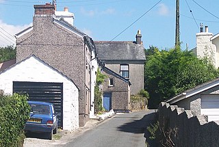
Gorran Churchtown is a village in the parish of St Goran, Cornwall, England. Gorran Churchtown is situated approximately nine miles (14 km) south-southwest of St Austell; Gorran Haven, the largest settlement in the parish, is a mile to the east.

Harrowbarrow is a village in the parish of Calstock in east Cornwall, England.
Higher Boscaswell is a hamlet near Pendeen in west Cornwall, England. It is east of Pendeen and on the B road from St Ives to St Just. Higher Boscaswell is included in the St Just in Penwith division on Cornwall Council.

Lamledra is a house near Gorran Haven in Cornwall, England, UK. It is situated immediately above Vault Beach. It was built in 1911 by the barrister, John Fischer Williams, and extended in the 1920s. It was formerly the residence of the Oxford academics Herbert and Jenifer Hart.
Norris Green is a village in Cornwall, England, UK. It was enlarged from a farming hamlet so that it now adjoins the neighbouring village of Higher Metherell. Both settlements are within the civil parish of Calstock which borders the River Tamar, the county boundary with Devon in south-east Cornwall.

Penare is a hamlet near Gorran Haven in Cornwall, England, UK. Penare is situated 1 mile (2 km) south-west of Gorran Haven.

Rising Sun is a hamlet near Calstock in Cornwall, England.
Treveor is a hamlet west of Gorran Haven, Cornwall, England, United Kingdom.
Trewollock is a hamlet north of Gorran Haven, Cornwall, England, United Kingdom.

The River Kensey is a river in east Cornwall, England, UK which is a tributary of the River Tamar.

