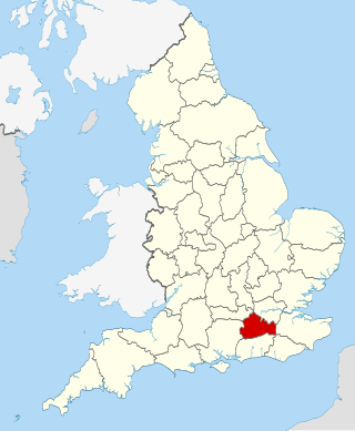
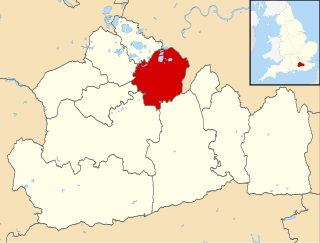
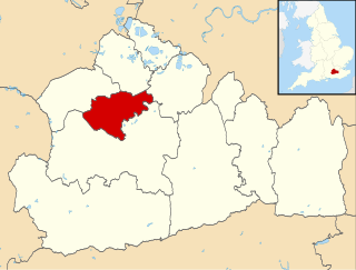
There are over 20,000 Grade II* listed buildings in England. This page is a list of the 52 Grade II* listed buildings in the district of Tandridge in Surrey. For links to similar articles in relation to the other 10 districts of Surrey see Grade II* listed buildings in Surrey.
Contents
| Name | Location | Type | Completed [note 1] | Date designated | Grid ref. [note 2] Geo-coordinates | Entry number [note 3] | Image |
|---|---|---|---|---|---|---|---|
| King Charles Cottage Restaurant | Bletchingley | House | 19th century | 11 June 1958 | TQ3272150790 51°14′27″N0°06′00″W / 51.240858°N 0.100071°W | 1029976 |  Upload Photo |
| Place Farm House including Cleves Cottage | Bletchingley | House | 16th century | 11 June 1958 | TQ3266252121 51°15′10″N0°06′02″W / 51.252833°N 0.100423°W | 1029989 | Upload Photo |
| The Hawthorns (Pendell Court) | Bletchingley | House/School | 1624 | 11 June 1958 | TQ3170651889 51°15′03″N0°06′51″W / 51.250969°N 0.114199°W | 1281104 |  |
| The Manor House | Bletchingley | House | Late 18th century | 11 June 1958 | TQ3160951718 51°14′58″N0°06′56″W / 51.249455°N 0.115651°W | 1204686 |  |
| The Whyte Harte Inn including Former Stable to Rear | Bletchingley | Inn | 16th century | 11 June 1958 | TQ3274550748 51°14′26″N0°05′59″W / 51.240475°N 0.099743°W | 1377531 |  |
| 42–44 High Street | Bletchingley | House | 18th century | 11 June 1958 | TQ3270850786 51°14′27″N0°06′01″W / 51.240825°N 0.100259°W | 1204531 | Upload Photo |
| Burstow Lodge | Burstow | House | C15 | 11 June 1958 | TQ3147144189 51°10′55″N0°07′13″W / 51.181823°N 0.120385°W | 1204768 |  |
| Crullings & Smallfield Place | Burstow | House | c. 1600 | 11 June 1958 | TQ3267043173 51°10′21″N0°06′13″W / 51.172416°N 0.103615°W | 1029963 | Upload Photo |
| Chaldon Court | Chaldon | Timber Framed House | 14th century | 21 September 1954 | TQ3082055676 51°17′07″N0°07′32″W / 51.285207°N 0.125503°W | 1029812 | Upload Photo |
| Tollsworth Manor House | Chaldon | House | 17th century | 21 September 1954 | TQ3059954595 51°16′32″N0°07′45″W / 51.275543°N 0.129065°W | 1029822 | Upload Photo |
| Beddlestead House | Chelsham, Chelsham and Farleigh | Wealden Hall House | 15th Century | 11 June 1958 | TQ3986657739 51°18′06″N0°00′18″E / 51.301598°N 0.004936°E | 1029796 |  |
| Granary and Barn 15 Yards South West of Crowhurst Place | Crowhurst | Granary | 15th century | 9 March 1982 | TQ3859546336 51°11′58″N0°01′04″W / 51.199436°N 0.017696°W | 1377584 | Upload Photo |
| Mansion House Farm House | Crowhurst | House | 17th century | 11 June 1958 | TQ3911847414 51°12′32″N0°00′35″W / 51.208997°N 0.009797°W | 1029930 |  |
| Dwelly Farm House | Dormansland | Farmhouse | late C16/early 17th century | 11 February 1958 | TQ4170946000 51°11′44″N0°01′36″E / 51.195654°N 0.026712°E | 1029914 | Upload Photo |
| Hoopers Farm House | Dormansland | Farmhouse | 19th century | 11 June 1958 | TQ4269942788 51°10′00″N0°02′23″E / 51.166544°N 0.039597°E | 1205719 | Upload Photo |
| Puttenden Manor House | Dormansland | House | 17th century | 11 June 1958 | TQ4088145477 51°11′28″N0°00′53″E / 51.191158°N 0.014665°E | 1280736 | 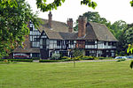 |
| Starborough Castle Walls and Garden House | Dormansland | Castle | 1754 | 11 June 1958 | TQ4260744120 51°10′43″N0°02′20″E / 51.178536°N 0.03881°E | 1205666 | Upload Photo |
| Lagham Manor | Godstone | Manor House | 16th century | 11 June 1958 | TQ3636448055 51°12′56″N0°02′56″W / 51.215421°N 0.048955°W | 1029769 | Upload Photo |
| St Mary's Almshouses and Chapel of St Mary | Godstone | Jettied House | 1872 | 11 June 1958 | TQ3569851465 51°14′46″N0°03′26″W / 51.246224°N 0.057194°W | 1188470 | 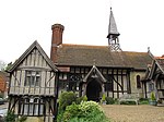 |
| The Bell Hotel | Godstone | House | c. 1700 | 11 June 1958 | TQ3509151467 51°14′47″N0°03′57″W / 51.246386°N 0.065885°W | 1029779 | 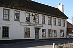 |
| The Old Packhouse | Godstone | House | Late 16th century | 11 June 1958 | TQ3571051096 51°14′34″N0°03′26″W / 51.242905°N 0.057162°W | 1294724 | Upload Photo |
| The White Hart | Godstone | Restaurant | 16th century | 11 June 1958 | TQ3505951557 51°14′50″N0°03′59″W / 51.247202°N 0.066309°W | 1188625 | 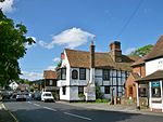 |
| Church of St Mary the Virgin | Horne | Church | 14th century | 11 June 1958 | TQ3368544349 51°10′58″N0°05′19″W / 51.182748°N 0.088668°W | 1377549 |  |
| Lowlands Farm House | Horne | House | 16th century | 25 April 1984 | TQ3635942407 51°09′53″N0°03′04″W / 51.164665°N 0.051169°W | 1205065 | Upload Photo |
| Batchelors Farm House | Limpsfield | Farmhouse | 15th century | 19 November 1984 | TQ4262448469 51°13′03″N0°02′27″E / 51.217613°N 0.040779°E | 1188980 | Upload Photo |
| Court Cottage | Limpsfield | Row | 16th century and 17th century | 11 June 1958 | TQ4055753090 51°15′35″N0°00′47″E / 51.259651°N 0.013015°E | 1188723 | Upload Photo |
| Detillens Cottage | Limpsfield | House | C20 | 11 June 1958 | TQ4056853096 51°15′35″N0°00′47″E / 51.259702°N 0.013175°E | 1377656 |  |
| Detillens House | Limpsfield | House | 1736 | 11 June 1958 | TQ4057353067 51°15′34″N0°00′48″E / 51.259441°N 0.013235°E | 1377657 | |
| Friars Cottage | Pains Hill, Limpsfield | House | C20 | 11 June 1958 | TQ4114851719 51°14′50″N0°01′15″E / 51.247185°N 0.020939°E | 1377660 | Upload Photo |
| Miles Butchers Shop and Dentists Surgery | Limpsfield | Cross Wing House | 15th century | 11 June 1958 | TQ4059453050 51°15′33″N0°00′49″E / 51.259283°N 0.013529°E | 1188829 | Upload Photo |
| Pebble Mill House Including Rangers Cottage to Rear | Limpsfield | House | c. 1776 | 11 June 1958 | TQ4087652731 51°15′23″N0°01′03″E / 51.256346°N 0.017442°E | 1029730 | Upload Photo |
| Tenchleys Manor | Itchingwood Common, Limpsfield | House | 1599 (Dendrochronology report) | 11 June 1958 | TQ4215250980 51°14′25″N0°02′06″E / 51.240295°N 0.035021°E | 1029762 | 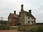 |
| The Moat Farm House including Barn Attached to Right | Limpsfield | House | Late 16th century | 11 June 1958 | TQ4252250697 51°14′16″N0°02′25″E / 51.23766°N 0.040205°E | 1029763 | Upload Photo |
| Church House & Star Inn Cottages | Lingfield | House | 16th century | 11 June 1958 | TQ3892243734 51°10′34″N0°00′50″W / 51.175974°N 0.014024°W | 1205173 | 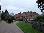 |
| Magnus Deo | Lingfield | House | 18th century | 11 June 1958 | TQ3858243527 51°10′27″N0°01′08″W / 51.174196°N 0.018964°W | 1205825 | Upload Photo |
| New Place | Lingfield | House | 1617 | 11 June 1958 | TQ3928643745 51°10′34″N0°00′32″W / 51.175984°N 0.008816°W | 1280486 |  |
| Old Town House and Old Town Cottage | Lingfield | House | 17th century | 11 June 1958 | TQ3889643739 51°10′34″N0°00′52″W / 51.176025°N 0.014394°W | 1029910 | 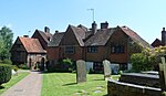 |
| The College including former Kitchen to South West | Lingfield | College | c. 1700 | 11 June 1958 | TQ3883543778 51°10′35″N0°00′55″W / 51.176391°N 0.015251°W | 1205289 |  |
| The Garth | Lingfield | House | 1729 | 11 June 1958 | TQ3807043666 51°10′32″N0°01′34″W / 51.175569°N 0.02623°W | 1205754 | Upload Photo |
| The Guest House (The Library) | Lingfield | House/Library | C20 | 11 June 1958 | TQ3887643828 51°10′37″N0°00′53″W / 51.17683°N 0.014645°W | 1205909 |  |
| The Old House | Lingfield | House | 17th century | 22 March 1973 | TQ3837243841 51°10′37″N0°01′19″W / 51.177069°N 0.021846°W | 1205370 | Upload Photo |
| Church of St Peter and St Paul | Nutfield | Church | 13th century | 11 June 1958 | TQ3092050870 51°14′31″N0°07′33″W / 51.241992°N 0.125828°W | 1377573 |  |
| Cogmans Farm House | Outwood | Base Cruck House | 15th century | 11 June 1958 | TQ3248044571 51°11′06″N0°06′21″W / 51.185024°N 0.105817°W | 1377560 | Upload Photo |
| Mayflower Cottage | Broadham Green, Oxted | Hall House | 15th century | 11 June 1958 | TQ3886051194 51°14′35″N0°00′43″W / 51.243028°N 0.012025°W | 1189581 | Upload Photo |
| Stocketts Manor | Oxted | House | 17th century | 11 June 1958 | TQ3925150387 51°14′08″N0°00′24″W / 51.235681°N 0.006741°W | 1189612 |  |
| The Old Bell Inn | Oxted | Inn | 16th century | 11 June 1958 | TQ3848552230 51°15′09″N0°01′01″W / 51.252429°N 0.016994°W | 1189620 | 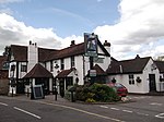 |
| The Old Cottage | Broadham Green, Oxted | House | 19th century | 11 June 1958 | TQ3870051150 51°14′34″N0°00′52″W / 51.242672°N 0.014333°W | 1029734 | Upload Photo |
| Hobbs Farm House | Tandridge | Farmhouse | 17th century | 11 June 1958 | TQ3754047377 51°12′33″N0°01′57″W / 51.209046°N 0.032387°W | 1029716 | Upload Photo |
| The Red Barn | Tandridge | House | 17th century | 11 June 1958 | TQ3703145232 51°11′24″N0°02′26″W / 51.189892°N 0.040488°W | 1189853 | Upload Photo |
| Church of St James the Greater | Titsey | Former Church | 1861 | 11 June 1958 | TQ4091354975 51°16′35″N0°01′08″E / 51.276502°N 0.018856°E | 1294053 |  |
| Church of All Saints | Warlingham | Church | 13th century | 21 September 1954 | TQ3557858960 51°18′49″N0°03′22″W / 51.313607°N 0.056071°W | 1188033 | 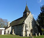 |
| The Vicarage | Warlingham | House | c. 1674 | 21 September 1954 | TQ3553158414 51°18′31″N0°03′25″W / 51.308712°N 0.056952°W | 1029794 | 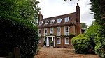 |