There are over 20,000 Grade II* listed buildings in England. This article comprises a list of these buildings in the county of Wiltshire.
There are over 20,000 Grade II* listed buildings in England. This article comprises a list of these buildings in the county of Wiltshire.
| Name | Location | Type | Completed [note 1] | Date designated | Grid ref. [note 2] Geo-coordinates | Entry number [note 3] | Image |
|---|---|---|---|---|---|---|---|
| Parish Church | Easton Grey, Wiltshire | Anglican Church | 1836 | 28 October 1959 | ST8808487642 51°35′15″N2°10′24″W / 51.587504°N 2.173389°W | 1023199 |  |
| Parish Church of St Denys (the Minster Church) | Warminster, Wiltshire | Parish Church | 11th century | 28 April 1952 | ST8692445494 51°12′31″N2°11′19″W / 51.208501°N 2.188565°W | 1364460 |  |
| Parks Court | Upton Scudamore, Wiltshire | Farmhouse | 15th century | 24 July 1969 | ST8655847759 51°13′44″N2°11′38″W / 51.228859°N 2.19389°W | 1021515 |  Upload Photo |
| Parliament Piece | Ramsbury, Wiltshire | House | c. 1620 | 22 August 1966 | SU2734471707 51°26′37″N1°36′29″W / 51.443699°N 1.607952°W | 1183680 | Upload Photo |
| Parnella House | Devizes, Wiltshire | House | 18th century | 9 April 1954 | SU0033861579 51°21′12″N1°59′48″W / 51.353286°N 1.996533°W | 1250833 |  |
| Parsonage Farmhouse | Salisbury, Wiltshire | Farmhouse | 16th century ORIGIN | 12 October 1972 | SU1325232260 51°05′22″N1°48′44″W / 51.089503°N 1.812162°W | 1243246 | Upload Photo |
| Part of King's Arms Hotel | Salisbury, Wiltshire | Public House | 1952 | 28 February 1952 | SU1457329657 51°03′58″N1°47′36″W / 51.066064°N 1.793404°W | 1259028 |  |
| Peacock Cottages | Winterbourne Dauntsey, Winterbourne, Wiltshire | House | 15th century | 29 May 1987 | SU1759134829 51°06′45″N1°45′00″W / 51.112487°N 1.750085°W | 1184635 |  |
| Philipps House | Dinton Park, Dinton, Wiltshire | Apartment | 1960 | 23 March 1960 | SU0041631910 51°05′11″N1°59′44″W / 51.086506°N 1.995438°W | 1318756 |  |
| Phipps Mausoleum in Westbury Cemetery | Westbury, Wiltshire | Mausoleum | 1871-1886 (on the OS map) | 31 March 1978 | ST8811351448 51°15′43″N2°10′18″W / 51.262064°N 2.171744°W | 1364424 |  |
| Pickwick Manor | Corsham, Wiltshire | House | 14th-century to 15th-century origins | 20 December 1960 | ST8626170527 51°26′01″N2°11′57″W / 51.433574°N 2.199029°W | 1363977 | Upload Photo |
| Polebarn House with Brick Boundary Wall, Gatepiers and Gates | Trowbridge, Wiltshire | House/Hotel | 1789 | 29 December 1950 | ST8589458055 51°19′17″N2°12′14″W / 51.321422°N 2.203809°W | 1021632 |  |
| Pond Farmhouse | Purton Stoke, Purton, Wiltshire | Farmhouse | 17th century | 17 January 1985 | SU0877690033 51°36′33″N1°52′29″W / 51.609064°N 1.874665°W | 1356025 | Upload Photo |
| Pound Farmhouse | Purton, Wiltshire | Farmhouse | Mid 15th century | 17 January 1955 | SU0934588976 51°35′58″N1°51′59″W / 51.599551°N 1.866476°W | 1023175 | Upload Photo |
| Pound Street Malthouse | Warminster, Wiltshire | Malt House | 18th century | 28 April 1952 | ST8665944907 51°12′12″N2°11′32″W / 51.203216°N 2.192336°W | 1036240 | Upload Photo |
| Premises on East Corner of New Street | Devizes, Wiltshire | Snuff factory | Modern | 9 April 1954 | SU0043661647 51°21′14″N1°59′42″W / 51.353898°N 1.995126°W | 1251673 |  |
| Priestley's House | The Green, Calne, Wiltshire | House | 16th century | 19 May 1950 | ST9996470725 51°26′08″N2°00′07″W / 51.435524°N 2.001908°W | 1270902 | Upload Photo |
| Priory Manor | The Priory, Kington St Michael, Wiltshire | House | 15th century | 20 December 1960 | ST8951277796 51°29′56″N2°09′09″W / 51.499003°N 2.152481°W | 1022340 | Upload Photo |
| Pythouse | Pythouse Park, West Tisbury, Wiltshire | Apartment | 1987 | 6 January 1966 | ST9063528564 51°03′23″N2°08′06″W / 51.05634°N 2.134997°W | 1318819 |  |
| RAF Club | Calne, Wiltshire | Cross Passage House | Early 17th century | 19 May 1950 | ST9985970826 51°26′11″N2°00′12″W / 51.436432°N 2.003418°W | 1247102 | Upload Photo |
| Railway Viaduct | Chippenham, Wiltshire | Railway Viaduct | 1841 | 22 June 1978 | ST9181573588 51°27′40″N2°07′09″W / 51.461206°N 2.119205°W | 1267956 |  |
| Rectory Farmhouse | Britford, Wiltshire | Detached House | Mid 17th century | 23 March 1960 | SU1627128499 51°03′20″N1°46′09″W / 51.055606°N 1.769224°W | 1023790 | Upload Photo |
| Remains of Old Fonthill Abbey | Fonthill Abbey Wood, Fonthill Gifford, Wiltshire | Country House | 1796-c1818 | 6 January 1966 | ST9182230997 51°04′42″N2°07′05″W / 51.078236°N 2.118116°W | 1146090 |  |
| Restrop House | Purton, Wiltshire | House | Late C16-Early 17th century | 17 April 1986 | SU0811486884 51°34′51″N1°53′03″W / 51.58076°N 1.884296°W | 1356028 | Upload Photo |
| Retaining Wall, Rails, Gates and Stable Yard Wall of No 17, Market Place | Devizes, Wiltshire | Gate | 19 September 1972 | SU0030361562 51°21′11″N1°59′49″W / 51.353133°N 1.997036°W | 1263273 | Upload Photo | |
| Riverside House | Axford, Wiltshire | House | 17th century | 22 August 1966 | SU2388370076 51°25′45″N1°39′28″W / 51.42919°N 1.657859°W | 1365448 | Upload Photo |
| Roche Court | Winterslow, Wiltshire | House | 1804-5 | 29 May 1987 | SU2501134064 51°06′19″N1°38′39″W / 51.105334°N 1.644142°W | 1300004 |  |
| Roche Old Court | Winterslow, Wiltshire | House | c1600-1625 | 23 March 1960 | SU2465934115 51°06′21″N1°38′57″W / 51.105808°N 1.649166°W | 1300012 |  |
| Rockley Manor | Rockley, Ogbourne St. Andrew, Wiltshire | House | 18th century | 27 February 1958 | SU1624871897 51°26′45″N1°46′03″W / 51.445832°N 1.767596°W | 1033851 | Upload Photo |
| Rose and Crown Public House and attached Stable Block | Chippenham, Wiltshire | Hall House | C14/C15 | 25 April 1950 | ST9221073141 51°27′26″N2°06′49″W / 51.457192°N 2.113509°W | 1268032 |  |
| Rosefield and Homefield with Gatepiers, Gate Standards and Gate | Trowbridge, Wiltshire | House | late C18/early 19th century | 29 December 1950 | ST8600757909 51°19′12″N2°12′08″W / 51.320112°N 2.202181°W | 1021633 | Upload Photo |
| Rowden Farmhouse with Barn, Outbuildings and Gatepiers attached | Chippenham, Lacock, Wiltshire | Farmhouse | Possibly earlier core-Pre 16th century | 16 June 1986 | ST9182572091 51°26′52″N2°07′08″W / 51.447746°N 2.119026°W | 1022194 | Upload Photo |
| Rudloe Manor | Rudloe, Box, Wiltshire | Manor House | Late Medieval | 24 July 1985 | ST8422870667 51°26′05″N2°13′42″W / 51.434779°N 2.22828°W | 1022808 |  |
| Former Salisbury and South Wiltshire Museum, 40 and 42 St Anns St | Salisbury, Wiltshire | House | 18th century | 28 February 1952 | SU1474329612 51°03′56″N1°47′28″W / 51.065655°N 1.79098°W | 1258828 |  |
| Sandcliffe | Devizes, Wiltshire | House | Early 18th century | 9 April 1954 | SU0015961632 51°21′14″N1°59′57″W / 51.353763°N 1.999103°W | 1251683 |  |
| Screen to Road in front of Portway House | Warminster, Wiltshire | Gate | 1760 | 26 May 1954 | ST8737745360 51°12′26″N2°10′55″W / 51.207306°N 2.182075°W | 1285678 |  |
| Seend House | Seend, Wiltshire | House | c1805-1810 | 19 March 1962 | ST9432760917 51°20′50″N2°04′58″W / 51.347304°N 2.082841°W | 1243855 | Upload Photo |
| Shalbourne Manor Farmhouse | Shalbourne, Wiltshire | Farmhouse | 16th century | 22 August 1966 | SU3143462912 51°21′52″N1°33′00″W / 51.364409°N 1.549882°W | 1184699 |  |
| Silver Street House | Bradford-on-Avon, Wiltshire | House | Early 18th century | 18 April 1952 | ST8273461034 51°20′53″N2°14′57″W / 51.34812°N 2.2493°W | 1036125 | Upload Photo |
| Somerset Hospital | Froxfield, Wiltshire | Almshouses | 1694 | 22 August 1966 | SU3000668090 51°24′40″N1°34′12″W / 51.411043°N 1.569956°W | 1034076 |  |
| Southwick Court Farmhouse | Southwick, Wiltshire | Farmhouse | Late 16th century | 11 September 1968 | ST8451155808 51°18′04″N2°13′25″W / 51.301181°N 2.223557°W | 1194818 |  |
| Spye Arch Lodge | Bowden Hill, Bromham, Wiltshire | Gate Lodge | 16th century | 19 March 1962 | ST9417067938 51°24′38″N2°05′07″W / 51.410433°N 2.085213°W | 1033912 |  |
| St Cecilia's | Calne, Wiltshire | House | Early 19th century | 19 May 1950 | ST9966671170 51°26′22″N2°00′22″W / 51.439525°N 2.006195°W | 1247117 | Upload Photo |
| St Edmund's School | Salisbury, Wiltshire | School | 1860 | 12 October 1972 | SU1458430349 51°04′20″N1°47′36″W / 51.072287°N 1.79322°W | 1273059 |  |
| St Elizabeth's Convent and St Osmund's Roman Catholic Primary School | Salisbury, Wiltshire | Church School | c. 1890 | 28 February 1952 | SU1450929217 51°03′44″N1°47′40″W / 51.062109°N 1.794335°W | 1023664 |  |
| St Johns Court | Malmesbury, Wiltshire | Terrace | 1966 | 18 January 1949 | ST9351686945 51°34′53″N2°05′42″W / 51.581326°N 2.094971°W | 1269276 | Upload Photo |
| St John's Hospital Chapel | Wilton, Wiltshire | House | 18th century | 4 August 1951 | SU0941331440 51°04′56″N1°52′01″W / 51.082204°N 1.866997°W | 1198954 |  |
| St Martin's House | Salisbury, Wiltshire | House | 18th century | 28 February 1952 | SU1476829681 51°03′59″N1°47′26″W / 51.066275°N 1.790621°W | 1258755 | Upload Photo |
| St Mary House | Chippenham, Wiltshire | House | Late 16th century | 25 April 1950 | ST9231473168 51°27′27″N2°06′43″W / 51.457436°N 2.112013°W | 1267937 | Upload Photo |
| St Nicholas's Hospital | Salisbury, Wiltshire | Hospital | Founded in 13th century | 28 February 1952 | SU1439629143 51°03′41″N1°47′45″W / 51.061447°N 1.795951°W | 1259077 |  |
| St Olaves | Bradford-on-Avon, Wiltshire | House | 18th century | 18 April 1952 | ST8286460975 51°20′51″N2°14′51″W / 51.347593°N 2.247431°W | 1185137 |  |
| Stable Block to Tottenham House | Great Bedwyn, Wiltshire | Stable | 1818 | 22 August 1966 | SU2490364129 51°22′32″N1°38′37″W / 51.375674°N 1.643603°W | 1365488 | Upload Photo |
| Stables, Riding School and Entrance Archway to Corsham Court | Corsham Court, Corsham, Wiltshire | Stables | c1700-20 | 20 December 1960 | ST8737770579 51°26′03″N2°10′59″W / 51.434068°N 2.182977°W | 1182308 |  |
| Statue of Fame in Cupola, at South End of Parterre | Longford Park, Odstock, Wiltshire | Statue | 1767 | 28 March 1985 | SU1713626567 51°02′18″N1°45′25″W / 51.038209°N 1.756973°W | 1023842 | Upload Photo |
| Staynings | Salisbury, Wiltshire | House | Early 18th century | 28 February 1952 | SU1421329799 51°04′02″N1°47′55″W / 51.06735°N 1.798536°W | 1023636 | Upload Photo |
| Sticke Tennis Court to West of Hartham House | Hartham, Corsham, Wiltshire | Cricket Pavilion | Built 1890s | 1 August 1986 | ST8590772091 51°26′51″N2°12′15″W / 51.447628°N 2.204184°W | 1284355 | Upload Photo |
| Store House and Animal House to the South East of Manor Farmhouse | Hankerton, Wiltshire | Animal House | 1706 | 2 May 1977 | ST9774690857 51°37′00″N2°02′02″W / 51.616534°N 2.033951°W | 1022244 | Upload Photo |
| Stowford Manor | Wingfield, Wiltshire | Farmhouse | Late 15th century | 13 November 1962 | ST8110157672 51°19′04″N2°16′21″W / 51.317838°N 2.272568°W | 1180800 | Upload Photo |
| Summer House at Milford Manor | Salisbury, Wiltshire | Summerhouse | Early 18th century | 12 March 1984 | SU1559629682 51°03′59″N1°46′44″W / 51.066263°N 1.778804°W | 1272838 | Upload Photo |
| Summer House at Wilbury House | Newton Tony, Wiltshire | Summerhouse | c. 1710 | 29 May 1987 | SU2227441610 51°10′24″N1°40′58″W / 51.173299°N 1.68277°W | 1313163 | Upload Photo |
| Summer House in Garden of No 15, The Close | Salisbury, Wiltshire | Summerhouse | Late C17/Early 18th century | 12 October 1972 | SU1453929713 51°04′00″N1°47′38″W / 51.066569°N 1.793887°W | 1023590 | Upload Photo |
| Sundial House | Bradford-on-Avon, Wiltshire | House | 18th century | 18 April 1952 | ST8275461043 51°20′54″N2°14′56″W / 51.348202°N 2.249014°W | 1364480 | Upload Photo |
| Sunton House | Sunton, Collingbourne Ducis, Wiltshire | House | c. 1710 | 4 June 1952 | SU2428054768 51°17′30″N1°39′11″W / 51.291531°N 1.653189°W | 1285379 | Upload Photo |
| Tedworth House | Tidworth, Wiltshire | Country House | c. 1860 | 24 October 1984 | SU2327247545 51°13′36″N1°40′05″W / 51.226626°N 1.668112°W | 1339397 |  |
| Temple about 32m west of Belcombe Court | Bradford-on-Avon, Wiltshire | Garden Temple | 1740s | 18 April 1952 | ST8170060621 51°20′40″N2°15′51″W / 51.344374°N 2.264125°W | 1036019 | Upload Photo |
| Terraces with Ornamental Balustrades and Steps to South of the Hall, including retaining Walls running to East and West and Garden Wall | Bradford-on-Avon, Wiltshire | Terraces | 18th century | 23 August 1974 | ST8285560886 51°20′48″N2°14′51″W / 51.346793°N 2.247556°W | 1036053 |  |
| The Ark | Devizes, Wiltshire | House | Early 19th century | 9 April 1954 | SU0047061191 51°20′59″N1°59′41″W / 51.349797°N 1.994638°W | 1250355 | Upload Photo |
| The Bear Hotel | Devizes, Wiltshire | Wall | Early 19th century | 9 April 1954 | SU0035861448 51°21′08″N1°59′46″W / 51.352108°N 1.996246°W | 1250363 |  |
| The Black Swan Inn | Devizes, Wiltshire | Hotel | 18th century | 9 April 1954 | SU0034961565 51°21′11″N1°59′47″W / 51.35316°N 1.996375°W | 1263051 |  |
| The Cedars | Devizes, Wiltshire | House | Late 18th century | 9 April 1954 | ST9982561772 51°21′18″N2°00′14″W / 51.355022°N 2.0039°W | 1263761 | Upload Photo |
| The Chantry | Mere, Wiltshire | House | 1989 | 6 January 1966 | ST8112932217 51°05′20″N2°16′15″W / 51.088952°N 2.270819°W | 1130724 | Upload Photo |
| The Chantry | Warminster, Wiltshire | House | circa 1750-1760 | 28 April 1952 | ST8731945154 51°12′20″N2°10′58″W / 51.205453°N 2.182898°W | 1036217 |  |
| The Chantry and Little Chantry | Bradford-on-Avon, Wiltshire | House | 16th century | 18 April 1952 | ST8232060845 51°20′47″N2°15′19″W / 51.346408°N 2.255235°W | 1364531 |  |
| The Cloisters | Salisbury, Wiltshire | Timber Framed House | C15/C16 | 28 February 1952 | SU1457429685 51°03′59″N1°47′36″W / 51.066316°N 1.793389°W | 1273188 |  |
| The Cloisters, Iford Manor | Iford, Westwood, Wiltshire | Garden | 1914 | 13 November 1962 | ST8016158878 51°19′43″N2°17′10″W / 51.32865°N 2.286123°W | 1021878 |  |
| The Conduit House | Bowden Hill, Lacock, Wiltshire | Conduit House | Mid 16th century | 7 January 1987 | ST9376667981 51°24′39″N2°05′28″W / 51.410815°N 2.091022°W | 1363959 | Upload Photo |
| The Corner House | Lacock, Wiltshire | Cruck House | Early 17th century | 20 December 1960 | ST9155468557 51°24′57″N2°07′22″W / 51.415965°N 2.12284°W | 1363927 |  |
| The Court House | Bratton, Wiltshire | Cross Passage House | Late 15th century | 11 September 1968 | ST9106152616 51°16′21″N2°07′46″W / 51.272621°N 2.129524°W | 1193662 |  |
| The Courthouse | Downton, Wiltshire | Detached House | Late 17th century | 23 March 1960 | SU1748421419 50°59′31″N1°45′08″W / 50.991907°N 1.752257°W | 1023905 | Upload Photo |
| The Courts | Holt, Wiltshire | Country House | Early 18th century | 13 November 1962 | ST8611461803 51°21′18″N2°12′03″W / 51.355128°N 2.200799°W | 1364103 |  |
| The Deanery | Salisbury, Wiltshire | House | 17th century | 28 February 1952 | SU1442729592 51°03′56″N1°47′44″W / 51.065484°N 1.795491°W | 1252023 |  |
| The Dower House | Castle Combe, Wiltshire | House | Late 17th century | 20 December 1960 | ST8421777248 51°29′38″N2°13′43″W / 51.493952°N 2.228734°W | 1199036 |  |
| The Downton Press and The White Horse | Downton, Wiltshire | House | Early 16th century | 23 March 1960 | SU1750521490 50°59′33″N1°45′07″W / 50.992545°N 1.751954°W | 1300702 |  |
| The Gatehouse and attached Front Wall on South Side | Chitterne, Wiltshire | Detached House | Late 16th century | 11 September 1968 | ST9916544222 51°11′50″N2°00′48″W / 51.197215°N 2.013331°W | 1364348 | Upload Photo |
| The Georgian Boathouse | Fonthill Park, Fonthill Bishop, Wiltshire | Boat House | Mid 18th century | 6 January 1966 | ST9342032686 51°05′36″N2°05′43″W / 51.093445°N 2.095336°W | 1146058 | Upload Photo |
| The Golden Gates, Bowood House | Derry Hill, Calne Without, Wiltshire | Gate Lodge | C20 | 15 December 1972 | ST9569070495 51°26′00″N2°03′48″W / 51.433438°N 2.06339°W | 1253792 |  |
| The Greathouse | Kington Langley, Wiltshire | House | Late 17th century | 20 December 1960 | ST9295677077 51°29′33″N2°06′10″W / 51.492593°N 2.102852°W | 1022321 |  |
| The Grotto at Bowden Park | Bowden Park, Lacock, Wiltshire | Grotto | c. 1800 | 7 January 1987 | ST9380368096 51°24′43″N2°05′26″W / 51.41185°N 2.090492°W | 1022134 | Upload Photo |
| The Grove | Corsham, Wiltshire | House | 1737 | 20 December 1960 | ST8716370233 51°25′51″N2°11′10″W / 51.430952°N 2.186043°W | 1198550 | Upload Photo |
| The Guildhall | Salisbury, Wiltshire | Guildhall | 1788-1795 | 28 February 1952 | SU1449729985 51°04′08″N1°47′40″W / 51.069016°N 1.794476°W | 1242739 |  |
| The Haunch of Venison | Salisbury, Wiltshire | House | Established 1320 | 28 February 1952 | SU1436029960 51°04′08″N1°47′47″W / 51.068794°N 1.796432°W | 1273531 |  |
| The Ivy Longhouse and the Ivy Stables | Chippenham, Wiltshire | House | 1996 | 25 April 1950 | ST9169773201 51°27′28″N2°07′15″W / 51.457724°N 2.120894°W | 1268174 | Upload Photo |
| The Lansdowne Monument | Cherhill Down, Calne Without, Wiltshire | Obelisk | 1845 | 31 July 1986 | SU0477469309 51°25′22″N1°55′58″W / 51.422773°N 1.93273°W | 1253569 |  |
| The Manor House | Ansty, Wiltshire | Farmhouse | 16th century | 6 January 1966 | ST9560526357 51°02′12″N2°03′51″W / 51.036555°N 2.064057°W | 1300354 |  |
| The Manor House | Milton Lilbourne, Wiltshire | House | c1710-30 | 4 June 1952 | SU1896760537 51°20′37″N1°43′45″W / 51.343604°N 1.729076°W | 1035694 |  |
| The Manor House | Seend, Wiltshire | House | Before 1701 | 19 March 1962 | ST9447161044 51°20′54″N2°04′51″W / 51.348448°N 2.080775°W | 1243854 |  |
| The Manor House | Steeple Ashton, Wiltshire | House | c. 1900 | 11 September 1968 | ST9070057170 51°18′49″N2°08′05″W / 51.313564°N 2.134819°W | 1252488 | Upload Photo |
| The Manor House | Yatton Keynell, Wiltshire | Manor House | Possibly earlier-Pre 1659 | 20 December 1960 | ST8644576279 51°29′07″N2°11′48″W / 51.485297°N 2.196604°W | 1300423 | Upload Photo |
| The Manor House and Barn | Biddestone, Wiltshire | Cross Passage House | Possibly earlier-Pre 17th century | 20 December 1960 | ST8668073355 51°27′32″N2°11′35″W / 51.459012°N 2.193109°W | 1363596 |  |
| The Market Cross | Devizes, Wiltshire | Market Cross | 1814 | 9 April 1954 | SU0040661486 51°21′09″N1°59′44″W / 51.35245°N 1.995557°W | 1250362 |  |
| The Mechanics' Institute | Swindon | Market Hall | 1855 | 17 February 1970 | SU1458084781 51°33′42″N1°47′28″W / 51.561722°N 1.791068°W | 1198947 |  |
| The Milford Arms | Salisbury, Wiltshire | House | C15/C16 | 12 October 1972 | SU1464629958 51°04′08″N1°47′32″W / 51.068769°N 1.792351°W | 1258053 | Upload Photo |
| The Mount House | Great Somerford, Wiltshire | House | 16th century | 12 December 1951 | ST9639783035 51°32′46″N2°03′12″W / 51.546197°N 2.053352°W | 1022515 |  |
| The New Inn | Salisbury, Wiltshire | Cruck House | C15/C16 | 28 February 1952 | SU1437629776 51°04′02″N1°47′46″W / 51.067139°N 1.796211°W | 1258368 |  |
| The Obelisk | Warminster, Wiltshire | Obelisk | 1783 | 28 April 1952 | ST8695445133 51°12′19″N2°11′17″W / 51.205255°N 2.188122°W | 1194575 |  |
| The Old Court House | Castle Combe, Wiltshire | Jettied House | Early 16th century | 20 December 1960 | ST8421277154 51°29′35″N2°13′44″W / 51.493107°N 2.228802°W | 1022862 |  |
| The Old Manor House | Highworth, Swindon | House | Dated 1656 | 26 January 1955 | SU2025092453 51°37′50″N1°42′32″W / 51.630529°N 1.708835°W | 1355951 |  |
| The Old Manor House | Milston, Wiltshire | Manor House | 1613 | 10 January 1953 | SU1622845234 51°12′22″N1°46′09″W / 51.206088°N 1.769089°W | 1318536 | Upload Photo |
| The Old Parsonage | Steeple Ashton, Wiltshire | House | Early 15th century | 11 September 1968 | ST9078456956 51°18′42″N2°08′01″W / 51.311641°N 2.133608°W | 1252695 | Upload Photo |
| The Old Town Hall | Devizes, Wiltshire | Town Hall | During erection of present | 9 April 1954 | SU0043861416 51°21′07″N1°59′42″W / 51.351821°N 1.995097°W | 1252446 |  |
| The Old Vicarage and attached Railings | Chippenham, Wiltshire | Vicarage | Late C17/Early 18th century | 25 April 1950 | ST9232673227 51°27′29″N2°06′43″W / 51.457967°N 2.111842°W | 1267908 |  |
| The Pheasant Inn and Crewe's Hall | Salisbury, Wiltshire | Inn | 15th century | 28 February 1952 | SU1455930177 51°04′15″N1°47′37″W / 51.070741°N 1.793584°W | 1243120 |  |
| The Priory Barn | Bradford-on-Avon, Wiltshire | Tithe Barn | late medieval | 18 April 1952 | ST8247361065 51°20′54″N2°15′11″W / 51.348391°N 2.253049°W | 1364527 |  |
| The former Queen's Head Inn | Dunkirk, Devizes, Wiltshire | Terrace | 18th century | 9 April 1954 | ST9940861924 51°21′23″N2°00′36″W / 51.356388°N 2.009889°W | 1249469 |  |
| The Red House at Eastwell House | Potterne, Wiltshire | Garden Building | c. 1700 | 19 March 1962 | ST9935858004 51°19′16″N2°00′38″W / 51.32114°N 2.010598°W | 1258775 | Upload Photo |
| The Rose and Crown Inn | East Harnham, Salisbury, Wiltshire | Timber Framed House | 16th century | 28 February 1952 | SU1428428983 51°03′36″N1°47′51″W / 51.060011°N 1.797555°W | 1242271 |  |
| The Royal George Public House including Part of former No 19 | Salisbury, Wiltshire | House | 18th century | 12 October 1972 | SU1452630267 51°04′18″N1°47′39″W / 51.071551°N 1.794051°W | 1248750 |  |
| The Sanctuary | Steeple Ashton, Wiltshire | House | Early 16th century | 29 January 1988 | ST9084356954 51°18′42″N2°07′58″W / 51.311624°N 2.132762°W | 1252506 |  |
| The Sham Ruin | Corsham Court, Corsham, Wiltshire | Grotto | c. 1797 | 1 August 1986 | ST8734070575 51°26′03″N2°11′01″W / 51.434031°N 2.183509°W | 1284571 |  |
| The Sign of the Angel | Lacock, Wiltshire | House | Early C20 | 20 December 1960 | ST9158968574 51°24′58″N2°07′20″W / 51.416119°N 2.122337°W | 1198180 |  |
| The Spectrum Building (formerly the Renault Distribution Centre) | Swindon | 1981-2 | 18 September 2013 | SU1227285351 51°34′01″N1°49′28″W / 51.566902°N 1.824343°W | 1416061 |  | |
| The Tounson Almshouses | Calne, Wiltshire | Cross Passage House | 1950 | 19 May 1950 | ST9990670868 51°26′13″N2°00′10″W / 51.436809°N 2.002742°W | 1270992 |  |
| The Town Hall | Devizes, Wiltshire | Town Hall | 1806-08 | 9 April 1954 | SU0046861335 51°21′04″N1°59′41″W / 51.351092°N 1.994666°W | 1262331 |  |
| The Town Hall | Westbury, Wiltshire | Town Hall | Early 19th century | 29 December 1950 | ST8739251524 51°15′46″N2°10′55″W / 51.262732°N 2.18208°W | 1036308 |  |
| The Wardrobe | Salisbury, Wiltshire | House | 1254 | 28 February 1952 | SU1413429668 51°03′58″N1°47′59″W / 51.066174°N 1.799669°W | 1254383 |  |
| The White House | Highworth, Swindon | House | Late 17th century | 26 January 1955 | SU2001692469 51°37′50″N1°42′44″W / 51.630681°N 1.712215°W | 1023387 | Upload Photo |
| The Woodhouse | Chippenham, Wiltshire | House | Late C16-Early 17th century | 25 April 1950 | ST9233973199 51°27′28″N2°06′42″W / 51.457715°N 2.111654°W | 1267949 |  |
| Tidcombe Manor | Tidcombe, Tidcombe and Fosbury, Wiltshire | House | Mid-Late 18th century | 22 August 1966 | SU2898858380 51°19′26″N1°35′07″W / 51.323789°N 1.585382°W | 1365508 |  |
| Tower House | Malmesbury, Wiltshire | House | Mid 16th century | 18 January 1949 | ST9342687256 51°35′03″N2°05′47″W / 51.584122°N 2.096276°W | 1269271 |  |
| Trowle Manor Farmhouse | Trowle Common, Trowbridge, Wiltshire | Farmhouse | Older | 26 November 1976 | ST8417458660 51°19′37″N2°13′43″W / 51.326816°N 2.228518°W | 1021662 | Upload Photo |
| Turleigh Manor | Turleigh, Winsley, Wiltshire | House | Late 17th century to early 18th century | 13 November 1962 | ST8049060747 51°20′44″N2°16′53″W / 51.345466°N 2.281504°W | 1021905 | Upload Photo |
| Turner Memorial in the Churchyard about 45m south of Lady Chapel of the Church of St Michael | Melksham, Wiltshire | Chest Tomb | Early 19th century | 13 February 1985 | ST9026563678 51°22′19″N2°08′28″W / 51.372074°N 2.14124°W | 1021708 | Upload Photo |
| Two former Hangars on North Side of former Airfield | Yatesbury, Cherhill, Wiltshire | Aircraft Hangar | 1916 | 25 November 1987 | SU0520771296 51°26′26″N1°55′35″W / 51.440635°N 1.926474°W | 1283146 |  |
| Two Monuments in the Churchyard between 11m and 13m north of Tower of Church of St Mary the Virgin | Steeple Ashton, Wiltshire | Chest Tomb | Early to Mid 18th century | 11 September 1968 | ST9062557135 51°18′48″N2°08′09″W / 51.313248°N 2.135894°W | 1252398 | Upload Photo |
| Unidentified Monument in Churchyard, 3m south of Lady Chapel, Church of St Mary | Bishops Cannings, Wiltshire | Chest Tomb | 15th century | 29 April 1987 | SU0378864166 51°22′36″N1°56′49″W / 51.376536°N 1.946964°W | 1365975 | Upload Photo |
| Upavon Camp (Officers' Mess), Building 21 | Trenchard Lines, Upavon, Wiltshire | Officers Mess | 1914-1915 | 3 June 1986 | SU1550654878 51°17′34″N1°46′44″W / 51.292825°N 1.779009°W | 1365554 | Upload Photo |
| Upham House | Upper Upham, Aldbourne, Wiltshire | Country House | possibly earlier work | 22 August 1966 | SU2292777136 51°29′34″N1°40′16″W / 51.492708°N 1.671154°W | 1200440 |  |
| Urchfont Manor | Urchfont, Wiltshire | House | 15th century | 19 March 1962 | SU0358356962 51°18′42″N1°57′00″W / 51.311761°N 1.949979°W | 1035857 |  |
| Vale House | Salisbury, Wiltshire | House | 18th century | 28 February 1952 | SU1476129648 51°03′58″N1°47′27″W / 51.065979°N 1.790722°W | 1273247 | Upload Photo |
| Vastern House | Vastern, Wootton Bassett, Wiltshire | House | 15th century core | 15 August 1985 | SU0495381421 51°31′54″N1°55′48″W / 51.531676°N 1.92999°W | 1300114 |  |
| Vernleaze and attached Service Range and Garden Wall | Calne, Wiltshire | House | Early 19th century | 19 May 1950 | ST9959070122 51°25′48″N2°00′26″W / 51.430102°N 2.007287°W | 1247357 | Upload Photo |
| Victoria Hall | Salisbury, Wiltshire | House | 1716 | 28 February 1952 | SU1460230096 51°04′12″N1°47′35″W / 51.070011°N 1.792973°W | 1273287 | Upload Photo |
| Village Cross in Schoolyard | Lacock, Wiltshire | Village Cross | Late Medieval | 20 December 1960 | ST9157868436 51°24′54″N2°07′21″W / 51.414878°N 2.122492°W | 1363937 |  |
| Village Farmhouse | Charlton, Wiltshire | Farmhouse | Late 17th century | 12 December 1951 | ST9643388956 51°35′58″N2°03′10″W / 51.599435°N 2.052895°W | 1022224 | Upload Photo |
| Villetts House | Swindon | House | 1729 | 2 October 1951 | SU1574683807 51°33′11″N1°46′27″W / 51.552934°N 1.774291°W | 1355900 |  |
| Wall along Street to north of No 5, St Margaret's Place | Bradford-on-Avon, Wiltshire | House | 18th century | 18 April 1952 | ST8263160727 51°20′43″N2°15′03″W / 51.345356°N 2.250764°W | 1364496 | Upload Photo |
| Walls of Bailey to Old Wardour Castle | Wardour Park, Tisbury, Wiltshire | Wall | 1570s | 6 July 1987 | ST9383826396 51°02′13″N2°05′21″W / 51.036889°N 2.089258°W | 1318789 | Upload Photo |
| Warminster School | Warminster, Wiltshire | School | Mid 19th century | 28 April 1952 | ST8695345367 51°12′26″N2°11′17″W / 51.20736°N 2.188145°W | 1193680 |  |
| Well Close House | Bradford-on-Avon, Wiltshire | House | 17th century | 23 August 1974 | ST8209360720 51°20′43″N2°15′31″W / 51.345277°N 2.258488°W | 1036017 | Upload Photo |
| West Court Farmhouse | Shalbourne, Wiltshire | Farmhouse | C15-C17 | 30 July 1986 | SU3138962669 51°21′44″N1°33′02″W / 51.362226°N 1.550549°W | 1033981 | Upload Photo |
| West Hill House | Calne, Wiltshire | Apartment | 1950 | 19 May 1950 | ST9967271058 51°26′19″N2°00′22″W / 51.438518°N 2.006109°W | 1247319 | Upload Photo |
| West Portal of Box Tunnel | Box, Wiltshire | Railway Tunnel Portal | c. 1840 | 24 July 1985 | ST8292768905 51°25′08″N2°14′49″W / 51.418898°N 2.24691°W | 1284962 | 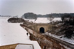 |
| West Portal of Middlehill Tunnel | Middlehill, Box, Wiltshire | Railway Tunnel Portal | 1840 | 27 July 1985 | ST8194068730 51°25′02″N2°15′40″W / 51.417294°N 2.261095°W | 1022803 | Upload Photo |
| Westbury Conservative Club (Ferndale House) | Westbury, Wiltshire | Wall | Early 18th century | 29 December 1950 | ST8741751566 51°15′47″N2°10′54″W / 51.26311°N 2.181723°W | 1194765 |  |
| Westbury House. Railings along east Side and walled Forecourt to south of Westbury House | Bradford-on-Avon, Wiltshire | House | Early 18th century | 18 April 1952 | ST8254060864 51°20′48″N2°15′07″W / 51.346585°N 2.252077°W | 1036119 |  |
| Westcroft | Trowbridge, Wiltshire | House | 1784 | 29 December 1950 | ST8541358261 51°19′24″N2°12′39″W / 51.323262°N 2.21072°W | 1182520 |  |
| Whistley House | Potterne, Wiltshire | Country House | 18th century | 19 March 1962 | ST9879959244 51°19′56″N2°01′07″W / 51.332289°N 2.018625°W | 1243109 | Upload Photo |
| White Hart Hotel | Calne, Wiltshire | Inn | Late 16th century | 19 May 1950 | ST9993670696 51°26′07″N2°00′08″W / 51.435263°N 2.00231°W | 1247314 |  |
| White Hart Hotel | Salisbury, Wiltshire | Hotel | Late 18th century | 28 February 1952 | SU1457129722 51°04′00″N1°47′36″W / 51.066649°N 1.79343°W | 1258980 |  |
| Wilcot Manor House | Wilcot, Wiltshire | Manor House | Early 17th century | 4 June 1952 | SU1397660790 51°20′46″N1°48′03″W / 51.346023°N 1.800721°W | 1364664 | Upload Photo |
| William IV Public House | Salisbury, Wiltshire | House | 17th century | 12 October 1972 | SU1465829924 51°04′06″N1°47′32″W / 51.068463°N 1.792181°W | 1259805 | Upload Photo |
| Wilsford House | Wilsford, Wilsford cum Lake, Wiltshire | House | 1904-6 | 15 April 1987 | SU1340139731 51°09′24″N1°48′35″W / 51.156678°N 1.809759°W | 1131008 | Upload Photo |
| Wilton Windmill | Wilton, Grafton, Wiltshire | Tower Mill | 1821 | 30 July 1986 | SU2756561620 51°21′11″N1°36′20″W / 51.352992°N 1.605553°W | 1034034 |  |
| Woolley Grange | Woolley Green, Bradford-on-Avon, Wiltshire | Manor House | 17th century | 23 August 1974 | ST8367461553 51°21′10″N2°14′09″W / 51.352815°N 2.235827°W | 1036151 |  |
| Woolmore Farmhouse | Bowerhill, Melksham Without, Wiltshire | Farmhouse | 1631 | 13 February 1985 | ST9163062493 51°21′41″N2°07′18″W / 51.361441°N 2.121602°W | 1021762 | Upload Photo |
| Workshop 25m north-east of Church of St James | Ansty Village, Ansty, Wiltshire | Banqueting House | 1570-80 | 6 January 1966 | ST9567726342 51°02′11″N2°03′47″W / 51.03642°N 2.06303°W | 1318675 |  |
| Wroughton House | Wroughton, Swindon | Cross Passage House | Early 18th century | 26 January 1955 | SU1381880256 51°31′16″N1°48′08″W / 51.521055°N 1.802237°W | 1185607 | Upload Photo |
| Zealys House | Chippenham, Wiltshire | Town House | Early 18th century | 25 April 1950 | ST9233573208 51°27′28″N2°06′42″W / 51.457796°N 2.111712°W | 1267907 |  |
![]() Media related to Grade II listed buildings in Wiltshire at Wikimedia Commons
Media related to Grade II listed buildings in Wiltshire at Wikimedia Commons